
Zoe Scopa
Not even close to as crowded as hikes like McAfee's knob or Dragon's Tooth and one of the few hikes in the area with great views over the water. The actual hay rock is also fun to climb on top of. Only downside is all the powerlines crossing the trail but they aren't around the major viewpoints.
4.0
HOW TO FIND THE TRAILHEAD: I missed the trail at first and added some extra mileage. Start on the donut falls trail, once you cross a bridge over the creek you'll see a trail sign with an arrow pointing left. Ignore the left arrow and go straight through to get to a fire road (FR019). Go left on the fire road after less than a mile the unmarked kessler peak trail comes up on the right but is easy to miss. As of June 2018 it is marked with a small carin but the trail itself is narrow and looks like a washed out creek bed. If you come to a flat gravel clearing on the left you have gone too far. The hike starts with the very busy donut falls trail, but once you get on the Kessler trail you'll have the woods to yourself. The first half of the trail is narrow and pretty overgrown so I'd recommend long pants. The brush clears up a bit at higher elevations but the trail is very steep the whole way. This hike actually made me finally give in and buy trekking poles since on the way down I had to find a walking stick in the woods just to keep my balance on the loose dirt and rocks on the way down. There are a couple abandoned mines near the top and once you make it to the summit the views are incredible!
4.0
Went in the winter and probably would be nice in the fall or the spring with the rhododendrons, but not the most exciting hike in the area. Very limited lookout, you're just looking across to the other side of a valley and can't see beyond at all. It was still a nice hike, but best to combine it with Wind Rock or Bald Knob (which both have much better views) nearby to make the drive worth it.
2.0
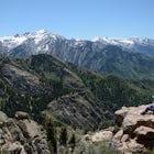
This was my first hike west of the Rockies and definitely wasn't easy. Wasn't quite ready for the altitude after living on the east coast and with over 1000ft of elevation gain per mile, minimal tree cover, and a near vertical rock scramble I wouldn't really consider it "intermediate." Really enjoyed the challenge, but needed lots of breaks. The scramble was my favorite part. I had 2L of water and ran out with a mile or so to go so make sure to bring plenty.
5.0
Beautiful hike the entire way. Went June 2nd and there was still a ton of snow later in the hike and Lake Catherine was still frozen over. Decent crowd at Lake Mary but very few went on to the other two lakes. With the snow it's pretty difficult to find the trail from Martha to Catherine as there are very few signs and the paths aren't visible. Got lost on the way back down for a little and had to do some bushwhacking which definitely made it an adventure.
5.0
Community
Mobile Apps

© 2024 The Outbound Collective - Terms of Use - Privacy Policy