
My dogs and hike this one all winter if we can get to it. We typically come in from end not described but indicated by the map. If you follow the map you will cross the dam and start on the south end of the trail-no suspension bridge. The text description takes you to the north end of the trail. The trail is mostly downhill out and there is one creek crossing that can be a little sketchy if you start from the south end. Plenty of views of the lake and Mt Baker. This is the end I prefer starting from.
4.0
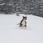
Did this in February one year with my dogs. Awesome! Make sure to check that the gates are open on Mt Loop or you might not be able to get there at all. If there has been a lot of snow and no one has cut a trail it can be difficult in places to find the trail. I always recommend using flagging tape to mark your trail. It snowed all day the day we went up and our tracks were pretty much gone on the way back down.
4.0
Just wanted to follow up on a previous review. The road is not closed every year at the same time. It is dependent on snowfall is my understanding. I've done this hike in January on years we have received very little snow. Checking if the road is open or not is appropriate as is the recommendation to check avalanche reports.
3.0
This has to be one of the most scenic highways in the state. You owe it to yourself to at least make the drive and to soak on the views from the road. Be extra careful on the pull-outs along the highway…cars can come through this area pretty fast.
4.0
Community
Mobile Apps

© 2024 The Outbound Collective - Terms of Use - Privacy Policy