
Backpack the Gillespie Pass Circuit, New Zealand
Makarora, New Zealand
Details
Distance
44.7 miles
Elevation Gain
4266 ft
Route Type
Loop
Description
Added by Sophie Burling
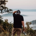
Outstanding 3-5 day hut-to-hut circuit encompassing rocky mountain vistas, towering waterfalls, raging blue rivers, golden river flats, thick wild bush and soaring mountain passes.
The small township of Makarora West is the kickoff point for this 3-5 day circuit that guides you through a strikingly beautiful and wild corner of the Southern Alps in New Zealand. My tramping companion and I decided to hike the route anticlockwise, although the trail can be traveled in both directions.
DAY 1
After a night spent in a cosy A-frame cabin, a 2.5km walk along the road, northbound from Makarora, brings you to the point at which you must ford the Makarora river to enter the trail at the mouth of the Young Valley. This is the first of many river crossings that will be encountered when hiking in this area. Usual river safety procedures should be followed and if the river is too high, there is a bridge several more kilometers up the road accessed from the Blue Pools carpark. The Blue Pools link track can then be used to join up with the start of the Gillespie Pass circuit track.
The track then follows through dense forest for 3-4 hours, sidling the Young River, before opening out onto grasslands and crossing the Young Forks Bridge. We stopped for lunch here but be warned - the sandflies are insatiable! The trail then renters the forest and climbs steeply up the side of a ravine before entering a steady climb to Young Hut. The trail snakes up and down and the track is carpeted with thick, twisting roots making for slow walking. There is drinking water, mattresses, bunks, and a fire at the hut but no cooking facilities. It is 20km (12.4) from the Makarora River to Young Hut and generally takes 6-7 hours.
DAY 2
After leaving Young Hut you immediately begin to climb up to above the bushline before the trail opens out into the stunningly beautiful head of the young valley. Walking to the end of the valley you then take a left turn and begin a steep and exposed climb to the top of Gillespie Pass at 1629m (5344ft). Views from the pass over the valleys below are apparently exceptional, and the severe glacier-clad peak of Mt Awful looms above you to the right. Unfortunately when my tramping partner and I completed the pass, the weather was atrocious with gale force gusts that had us clinging to the face of the mountain as the skies pummeled us with rain and hail, obscuring all views! The water poured off the mountains in angry torrents, waterfalls sluicing down the naked grey slopes, cast as mist to the air, grappling in the vicious wind. Although at times we could make out the outline of Mt Awful and it's glacier, most visibility was obscured by the enveloping cloud. From the pass, the trail then descends steeply back down to the bush line before briefly opening into a small valley sidling the Gillespie Stream. The trail then re-enters the beech forest and recommences a sharp descent down to the wide river flats in Siberia Valley. The trails through the beech forest are rough and gnarled tree roots are as useful as they are tedious, providing handholds and stairs up and down the slippery slopes. 45 minutes of easy walking, following the grass flats of Siberia Valley, brings you to Siberia Hut. Due to the weather when we walked this section of the trail, it took double this time as the small streams feeding the river were swollen and raging, fueled by those vast waterfalls pouring from the mountains. It was slow going finding suitable places to cross what would usually be gentle creeks. I even lost my footing and was swept downriver for a short distance in the stream directly in front of the hut. Young Hut to Siberia Hut is 12km (7.5 miles) and generally takes 6-8 hours, although with the challenges of the weather and swollen streams my tramping partner and I took a long, slow, wet and cold 9 1/2 hours to complete this section.
DAY 3
Crucible Lake is a side excursion or day trip that can be taken from the Siberia Valley. After vowing the evening before that we would not backtrack through the valley to the lake crucible trail head due to the high levels of the rivers and streams in the valley, we awoke to a still and clear day and the rivers had dropped quickly and substantially, back to near normal levels. Lake Crucible is an alpine lake nestled between a morraine and the slope of Mt Alba, located off the Siberia Valley. The trailhead is near where you exit the beech forest when you enter the Siberia Valley on day 2. Views of Mt Dreadful at the mouth of the valley are spectacular. Our river crossings over the Gillespie Stream and the Siberia Stream were uneventful and very soon we were sidling a waterfall, climbing up through the beech forest with the peak of Mt Alba just Visible above the trees. The climb is relatively short but the trail is strenuous and requires hands and feet climbing up the root covered slope. The track then flattens out and you cross through the stream feeding the waterfall and head up valley on its true right side, opening out into a sparse, rock-littered valley where you climb slowly uphill before ascending the rocky morraine that dams Crucible Lake at 1172m (3845ft). The lake is perfectly round and the richest of turquoise blues. In spring and early summer the surface is covered by chunks and floes of ice and is a fantastic place for a very refreshing dip! We hiked in late Autumn and by this stage of the year there was only one small iceberg left on the lake and the sun's rays never touched the gem coloured waters, obscured by the imposing peak of Mt Alba towering behind. Two Keas are lakeside residents and true to their intelligent and curious natures, are keen to interact with visiting hikers. The Crucible Lake day trip is 7km (4.3 miles) one-way and is advertised at taking 3-4 hours, although relieved of our heavy packs (left at Siberia Hut) we managed 2 hours 45 minutes up and 2 1/2 hours back down. There is an airstrip and a helicopter landing pad at Siberia Hut so it is possible to exit the circuit here.
DAY 4
We left at daybreak to make our way to Kerin Forks Hut. The trail through this section of the circuit has had a lot of work and is very well maintained proving for easy walking. It was the first time that we were able to walk and look at the lovely view of Mt Kuri and the river below, not where we were placing our hands and feet! It climbs a little uphill to skirt steep scree slopes before dropping through switchbacks into the Wilkin Valley. Kerin Forks Hut is on the true right side of the Wilkin River, so you must cross the river to get to it. Fording the Wilkin is challenging and the river is deep, cold and swift. There are a number of places to cross and we crossed at the uppermost section where the river sectioned into it's fast flow and slow flow arms, although the river is always changing so it's hard to recommend an ideal crossing point. Our initial plan had been to connect with the trail up to Top Forks and the Upper Wilkin Valley from Kerin Forks Hut, but concerns over weather (river crossings) and time constraints if the weather did turn bad, stopped us from continuing further up valley on this trip. Kerin Forks Hut is a lovely, cosy hut and was my favorite of the three we visited on the circuit. Siberia Hut to Kerin Forks is only 7km (4.3 miles) of relatively easy walking and takes 3-4 hours. Low daylight hours in late Autumn prevented us from continuing further from Kerin Forks in one day.
DAY 5
Starting out back towards Makarora, you must immediately re-cross the Wilkin River to get back on the track from Kerin Forks Hut - there really is no way to keep dry boots on this circuit! The Wilkin River is very deep and on this crossing my hiking partner was swept downstream in an unplanned swim! The Wilkin River Jetboat frequently visits Kerin Forks and many hikers and hunters access and leave the valley from this point. The jetboat costs NZD$110/person with a 1:30pm pick up. The hike from Kerin Forks to Makarora is easy compared to earlier sections of the trail, and the majority of the trail follows the Wilkin River, seeing you hike through the open, golden expanse of grass flatlands. Near the end of the valley the trail re-enters the bush to skirt the river. Literature on the trail implies that it may be quicker to cross the Wilkin here, follow the farmland on the other side and then recross the Wilkin again as the trail through the bush is rough and requires care. From my experience with river crossings, it is certainly quicker to keep to the bush track, which is no rougher than the track on day 1 and 2. There are a few places where slips and fallen trees provide obstacles but I still believe that the bush track is the quicker route. The marked track is recorded at 15km (9.3 miles) long and is advised to take 4-5 hours, although we completed it in 3 hours 45 minutes. The trail then peters out and you make your way though farmlands and cow herds before once again fording the Makarora River, bringing you out to State Highway 6. By the time we'd hiked through the farmland, crossed the river and walked the several kilometres back up the road to the car at Makarora West, we ended up adding another few hours to our day, which was unexpected. Once again the Makarora River was a serious river crossing not to be taken lightly, but there is a point where the farmer crosses in his 4 wheel drive vehicle that is marked with an orange topped waratah standard, where it is easiest to cross. The Pub at the Visitor Centre in Makarora West provides a very welcome burger, chips and beer in front of the fire on your return!
All of the huts on this trail are $15/night (or covered by a backcountry hut pass) and have mattresses, bunks, drinking water, fires and firewood. None have cooking facilities. All are first come first served and do not require bookings. It is not recommended to undertake this trail in winter as river crossings and alpine routes become challenging and avalanches are a real concern in sections of the trail. Be wary of the river crossings, many are not simply walking through water and they have the ability to leech out all warmth, energy and adrenaline. I found that serious crossings often took up to 40 minutes, and left you feeling pretty empty, cold, wet and tired before carrying on with the rest of your hike.
All in all it was a challenging but extraordinary circuit through a wild and majestic landscape. I will certainly be returning to explore more valleys and mountains in the area!
Download the Outbound mobile app
Find adventures and camping on the go, share photos, use GPX tracks, and download maps for offline use.
Get the appFeatures
Backpack the Gillespie Pass Circuit, New Zealand Reviews
This place looks awesome! Well Done!
5.0

Amazing hike with beautiful scenery and many river crossings. Including an extremely difficult crossing of the makarora river at both ends. Be prepared for all weather and do not cross the makarora if your alone or unsure. If your looking for an exciting, challenging adventure this ones for you. If you do not get a jet boat from Kerrin forks the 15 or 20km hike out is rough but exciting and beautiful in its own right. Though I would not recommend racing through it, we completed this circuit in just 2.5 days.
5.0
Leave No Trace
Always practice Leave No Trace ethics on your adventures and follow local regulations. Please explore responsibly!
Nearby

Hike to the Blue Pools

Camping on Lake Wanaka

Hike Brewster Track to Mt. Armstrong

Backpack the Brewster Hut Track

Hike Isthmus Peak

Backpack MacPherson Creek to Lake Barra
Community
Mobile Apps

© 2024 The Outbound Collective - Terms of Use - Privacy Policy