
Explore Lupin Falls
Comox-Strathcona D, British Columbia
Description
Added by Kaila Walton
A short hike to a beautiful 40m, two tiered cascading waterfall.
The drive to Lupin Falls from Courtenay BC is approximately 1.5 hours. Along the way you will drive past beautiful lakes, forests and mountains.
Once at the parking/day use area the trailhead for Lupin Falls is on the opposite side of the road. Everything is very well marked and signed. The walk to the falls is a short one and it is in the middle of a 1km loop. There is a nice viewing area and you can walk right up to the water as well.
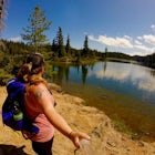
The area is beautiful and Lupin Creek flows into Buttle Lake, which is huge. It is about 23 kilometres (14 mi) long and 1.5 kilometres (0.9 mi) wide and around 120 metres (394 ft) deep in some parts.
If you manage to get out to Lupin Falls make sure you go a bit farther and check out the beautiful Lower Myra Falls.
Google Map directions to the parking area are found here.
From Courtenay BC head North to Campbell River on why 19 or 19A, once in Campbell River head West onto hwy 28 and drive until you see signs for Tahsis and Gold River. Don't turn right towards them, continue on straight until you see signs for the Lupin Falls parking lot.
Download the Outbound mobile app
Find adventures and camping on the go, share photos, use GPX tracks, and download maps for offline use.
Get the appFeatures
Explore Lupin Falls Reviews
This hike is an easy 1km ish loop and so worth the quick pit stop.
5.0
Leave No Trace
Always practice Leave No Trace ethics on your adventures and follow local regulations. Please explore responsibly!
Nearby

Hike through Marble Meadows to the Wheaton Hut

Hike to Lady Falls

King's Peak Trail

Hike to Landslide Lake

Hike to Cruikshank Canyon Lookout

Hike Mount Albert Edward
Community
Mobile Apps

© 2024 The Outbound Collective - Terms of Use - Privacy Policy