
Hike Mount Cheam
Fraser Valley E, British Columbia
Description
Added by Niki Pike
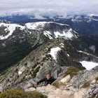
Distance: 9.5 km (5.9 miles) roundtrip. Duration: 4 hours. Elevation gain: 665-700 m (2,175-2,296 ft). Peak at 2,112 m (6,929 ft). Stunning 360-degree views of Lady Peak, Jones Lake, Fraser Valley, Harrison Lake, all the way to Mount Baker in the USAGreen meadows with wildflowers (late June-August).
Even at the parking lot, there is a stunning view of Lady Peak and Mount Cheam. Walk towards the big pile of logs and towards the old logging road. You will also see an outhouse – this will be your one and only time to use a toilet, so go now. The road continues for about 15 min. before reaching the first leg of the hike.
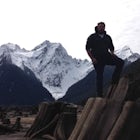
The trail descends about 50 m (164 ft) down, passing through a stunning green valley with 180-degree views of Lady Peak, Mount Cheam, and mountains as far as the USA, including a rarely seen angle of Mount Baker. There are two little camping spots beside Spoon Lake – please make SURE what you pack in you pack out. No fires are allowed, either. Also, be aware that some say that you are not supposed to camp here.
From this point on, the trail steepens as you start your ascent up the face of Lady Peak. After about 40 min. of zig-zagging, you will reach a somewhat level section of the trail. Make sure to stop to rest and take in the views of the valley and mountain ranges. Depending on the time of year, there may be a small lake as well.
The next leg of the journey will follow a goat trail with many switchbacks as it cuts into the mountainside, visible from below. At the base of the mountain, you will notice a small side trail leading towards Lady Peak, on your right. Take this short 5 min. walk for a stunning view of Jones Lake, below. Double pack on the same path, and you will begin another set of steep, rocky switchbacks that will take you 30-40 min. up to the ridge of Cheam.
At the ridge, you will have a stunning view of the entire Fraser Valley, and an 180-degree view of Lady Peak and the mountains below. If you look closely, you will see the route you took up, as well as the old logging road to the right. You can opt to stop hiking at the ridge, and rest on the bench or in the little rock hut, or you can continue to climb the next 100 m (328 ft) along the shale to the peak. The trail to the peak can be shady in some sections, and please use extreme caution not to get too close to the edge – there is a reason it's called Angel's Bowl.
After enjoying the view—and the little ground squirrels that call the summit home—it's time to head back down the mountain and take a long, bumpy ride down to the main road.
This trail can be done in spring, summer, and autumn, but you should be prepared to encounter snow. In June 2015 there was barely any snow on the trail, but that is not common for the time of year – this has been a warmer, drier year for Southern BC.
Getting there: Before the hike even begins, you are in for a long drive to get here. Note that you will need a 4x4 vehicle to make it up the decommissioned logging road. This road is VERY bumpy, with heaps of potholes and water wells. There is quite a steep incline for the entire 8 km (5 mi), so make sure you are in a vehicle with high clearance. The main access point is located along Chilliwack Lake Road. Get there early as the parking lot is small and fills up quickly.
From Vancouver, take Highway #1 (Trans Canada Highway) east and get off at Exit #119 Sardis. Turn right and follow Vedder Road southbound until you reach a 3-way intersection at Chilliwack Lake Road (there will be a bridge there). Turn left and follow the road for approximately 26 km (16 mi) and you will see a service road on the left, Foley Creek Forestry Service Road (signed). Follow this road for 2 km (1.2 mi) after crossing the bridge, then turn left at the junction. Drive another 2 km (1.2 mi) and turn right onto the Chipmunk Creek Forest Service Road (there is a gravel pit at this location). Continue for the next 8 km (5 mi) as the road becomes very rough and steep, and you will arrive at the parking area. There are a few turns offs along the last section of the road, but if you stick to the beaten path there shouldn't be an issue, just watch for people coming down the mountain.
Download the Outbound mobile app
Find adventures and camping on the go, share photos, use GPX tracks, and download maps for offline use.
Get the appFeatures
Hike Mount Cheam Reviews
Hiked Mt Cheam this past Saturday! (Fall 2014) Beautiful hike! Of course it helped that we had great weather of +25 and clear skies! Definitely need a truck/jeep to get up to the trail head. Don’t even attempt to take your car on this road. But thanks to the road you get to start the hike at a good elevation and enjoy beautiful view for the whole hike! Every part of the hike is very enjoyable. Majority of the hike is spent out in the open rather than covered by trees. If it is hot, make sure you have enough water; I went through my 2 litres. All ages are able to do this hike, so long as they are up for a bit of a challenge. The incline is not extreme, lots of easy parts. Took us about 2 hours up and 1 hour down; going at a pretty comfortable pace, slower than my usual. Spectacular view at the top! And Lady Peak looks very magnificent – I think I will have to try her next year. God’s creation is on display for those up for a bumpy drive!
5.0
This hikes rewards far outweigh the cost, the view is the best in the eastern fraser valley with views as far west as the ocean on the best of days and the cascades and Mt. Baker are absolutely stunning especially when you catch the sunrise. If you are an extreme adventurist id recommend Lady Peak as well a little bit more of a scramble but provides an even better view and to my knowledge is the highest peak in the region.
5.0
Leave No Trace
Always practice Leave No Trace ethics on your adventures and follow local regulations. Please explore responsibly!
Nearby

Explore Bridal Veil Falls in Chilliwack

Paddle on Jones Lake, BC

Camp at Jones Lake

Hike to Elk Mountain

Hike to Lindeman & Greendrop Lakes

Hike to Porcupine Peak
Community
Mobile Apps

© 2024 The Outbound Collective - Terms of Use - Privacy Policy