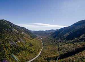
Franconia Notch, New Hampshire
Top Spots in and near Franconia Notch
-
Lincoln, New Hampshire
For the point to point option first drop a car off at one end of the trail then return to the other. The south end is located at the Flume Gorge Parking lot and the north end is at a parking lot located about a half mile off Route 93, Exit 35 which takes you onto route 3 (44°12'11.3"N 71°40'51.7...
Read more
-
Lincoln, New Hampshire
Driving the Kancamagus Highway is something you can do as a way to cross the White Mountain National Forest quickly from I-93 in the east to Conway, or it can be an entire day's activity. In the fall, it's almost impossible not to stop at every turn-off on the scenic highway as it winds through t...
Read more
-
Lincoln, New Hampshire
Franconia Falls Trail, starting at the Lincoln Woods Trailhead, features natural waterslides, a swimming hole, and fun for all ages. The Franconia Falls Trail is located in White Mountain National Forest, allows dogs, and is a perfect day trip year round!
This trail is also frequently used in th...
Read more
-
Lincoln, New Hampshire
The Franconia Brook Trail is a 16 mile out and back trail in White Mountain National Forest. The trail features a river, and is primarily used for hiking. This trail is also great for cross country skiing or snowshoeing in the winter.
The trailhead is approximately eight miles from Thirteen Fall...
Read more
-
Lincoln, New Hampshire
Park at the Lincoln Woods Visitors Center off the Kancamagus Highway where the Lincoln Woods Trailhead begins. Because of such a long hike, it's best to start at daybreak, or as early as possible to make it back before dark. The trail starts at the beginning of a suspension bridge crossing the Ea...
Read more
-
Sugar Hill, New Hampshire
Every year, more or less around the second week of June, the village of Sugar Hill boasts a magnificent show of lupines. There are several concentrations of lupines in fields along the road, but the highlight of a visit to Sugar Hill is the small hillside near St. Matthew's Church. The vistas tow...
Read more
-
Benton, New Hampshire
The trailhead is located along Lost River Road. There is a $5.00 day use parking pass required. The trail starts off on the Beaver Brook Trail (also the Appalachian Trail). The trail consists of cascades of rocks, wood-block steps and metal rungs (not all entirely in tact). It is very often ...
Read more
-
Lincoln, New Hampshire
The Hancock trailhead is located at the infamous hairpin turn of the Kancamagus Highway in the White Mountains. The trail itself crosses the road and starts at 2000 feet of elevation on the Hancock Notch trail. It remains fairly flat for the first 3 miles of the trail. After 1.8 miles you will hi...
Read more
-
Lincoln, New Hampshire
4.0
6.8 mi
/ 2677 ft gain
Start out at the Greeley Pond trailhead off of the Kancamagus Highway. After 1.3 miles the trail splits--bear right to get onto the Mt. Osceola Trail. Continue 1.5 miles to the summit. This summit hike offers a different kind of reward. Views are limited from the peak of Mt. Osceoloa, which allow...
Read more
-
Thornton, New Hampshire
This short hike starts out from the Tecumseh Trailhead parking lot along Tripoli Road at an elevation of 1,820 feet. The trail heads south from the parking area and almost immediately crosses a few brooks which may be difficult at high water. The first mile or so is a relatively gradual ascent.
O...
Read more
-
Jefferson, New Hampshire
The Sugarloaf Trail begins at the Sugarloaf trailhead on Zealand Road off of US 302. There are two trails that begin at this trailhead--be sure to cross the bridge over the Ammonoosuc and look for the "Sugarloaf Trail" sign.
The trail begins following the Ammonoosuc River for a short while before...
Read more
-
Woodstock, New Hampshire
4.8
7.4 mi
/ 2400 ft gain
Mount Moosilauke is a 4000 footer located in the White Mountain Range of New Hampshire. The summit peaks at 4,802 feet with a prominence of 2,933 feet.If you're new to exploring the White Mountain range this will definitely be a great introduction to what it can offer. The Gorge Brook Trail is th...
Read more
-
Jefferson, New Hampshire
The Pemigewasset Wilderness is a 45,000-acre treasure embedded within the spectacular “Whites” of New Hampshire. It’s a remote, less often travelled wilderness than the nearby Presidential Range but no less spectacular. The winter “Pemi Traverse”, a 23 mile tour from Bretton Woods to Lincoln, jum...
Read more
-
Warren, New Hampshire
5.0
7.1 mi
/ 2454 ft gain
To get to the trailhead, take the 25N, turn right onto High Street and continue along this road until it comes to an end. The Mt Moosiulauke Glencliff Trail takes you through seven miles of forest and mountain scenery. The trail features impressive vistas and eye-catching wildflowers, which might...
Read more
-
Carroll, New Hampshire
5.0
3.07 mi
/ 958 ft gain
This hike begins at the trailhead behind Crawford Depot. The first 1/4 mile of the trail is relatively level. You will cross two small streams before the trail begins to steepen. For much of the trek up to the top of the mountain you will be following an abandoned carriage road. Along the sid...
Read more
-
Thornton, New Hampshire
Begin at the Mt. Tecumseh trailhead. You will hike for 1.2 miles before your first vista. Continue from there another mile until you arrive at the junction with the Sosman Trail. Stay right and continue another 0.3 miles to reach the summit of Mt. Tecumseh. At just over 4,000' this peak offers in...
Read more


