Hagarville, Arkansas
Top Spots in and near Hagarville
-
Winslow, Arkansas
White Rock Rim Trail
5.02.08 mi / 335 ft gainThe trail around the Rim of White Rock Mountain is one of the best trails for vantage points. Nestled in the beautiful Boston Mountains in north central area of Arkansas. The White Rock Rim trail is an easy 2 mile loop trail that is moderately hiked year round. Start at the parking area and he...Read more -
Mulberry, Arkansas
Backpack along Hurricane Creek
6 miAfter arriving at the trailhead near the Shores Lake Campground (there is a $3 parking fee, so bring cash), head along the path and go west at the T-junction. Continue going west/northwest and you’ll cross over a forest road. Stay on the trail as it gradually descends, then veer off-trail to the ...Read more -
Morrilton, Arkansas
Camp at Petit Jean SP
Located between Ft. Smith and Little Rock, just south of Interstate 40, you will find the state treasure that is Petit Jean State Park. Its central location makes it very easy for any one to visit. The main hub of the State Park is the beautiful Mather Lodge, which has a rooms to rent, a restaura...Read more -
Morrilton, Arkansas
Cedar Falls
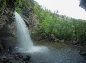
4.82.01 mi / 305 ft gainWhen I did this hike it was unbelievable. This entire valley looks like something out of a painting. If at all possible, I recommend that you plan your trip around the rain, because after a heavy rain the valley is full of waterfalls.Getting there: Cedar Falls is located in Petit Jean State Park ...Read more -
Morrilton, Arkansas
Hike the Seven Hollows Trail at Petit Jean SP
5.04.5 miStart the trail at the marked Seven Hollows Trailhead just off of Petit Jean Mountain Road- there's a small parking lot and signage board. The path is dog-friendly, with lots of springtime stream crossings and swimming opportunities. You can choose to take the 4-mile loop trail in either directi...Read more -
Huntsville, Arkansas
Kings River Overlook
5.01.2 mi / 145 ft gainThis is a great family hike short enough for little ones but with enough features to keep little ones engaged. From the parking area, it's about .6 miles on a relatively flat, well-marked trial to the overlook. (Plenty of room to step off trail for social distancing) We went in April with thre...Read more -
Huntsville, Arkansas
Tea Kettle Falls Trail
3.22.97 mi / 289 ft gainFinding Tea Kettle Falls is the most challenging part of this adventure. The trailhead is located in the McIlroy-Madison County Wildlife Management Area in northwest Arkansas. From Forum, travel 6.5 miles north on Hwy 23 to gravel road #447. It is approximately 13 miles south of Eureka Springs ...Read more

