
The Distant Desert: Backpacking the Trans-Zion Trek
Four day backpacking trip through some of the most spectacular and diverse desert scenery in America.
It was 10 minutes before 7 AM, and I stood behind 3 other people at the entrance to the Zion National Park Visitor Center. I paced in a small circle, and peered up for a few glances of the canyon walls, still brown and reddish, waiting for the sun to hit them. Behind me, a few more anxious faces appeared in line. The small crowd stood there, making small conversation. Finally, a figure moved behind the glass, and everyone stopped talking as the deadbolt of the front door turned with a click. I filed in, the order understood clearly, and waited by an informational map. My heart beat quickly as I knew the next few minutes would make or break my trip.
-----------------------------
It was springtime in the Pacific Northwest, and I needed to get away. I had a couple weeks off, and I was really amped up to do some backpacking; somewhere where it wasn’t raining nearly every day. I checked Mount Rainier’s “Wonderland Trail” – apparently it wasn’t doable until July. So I looked further south, and found the “Trans-Zion Trek”, a four to five day journey through “some of the most spectacular desert scenery in America”. I was hooked. Sunshine, heat, and red rock beckoned me as I planned for a backpacking and climbing trip down to Zion.
The only problem was I didn’t have a permit. To get a wilderness permit for National Parks in the USA, you have to book months in advance. Luckily, the National Parks Service has recognized that this is a problem for those of us with changing schedules, and they have set aside a good number of permits that can only be claimed on the day of, or the day before your trip. These are on a first-come, first-serve basis. This is what led me to the Visitor Center at 7 AM, the day before I planned to start my trip.
“Next.” I walked up briskly to the counter where the ranger sat, and told the guy that I wanted to do the Trans-Zion trek in 3, 4, or 5 days, and that I was open to any campsite they had open. He went through the first options. “Full, full, full…. Oh wait – here’s one opening. Yep, this one is open too.” I pointed at the map for the last night. “Site 3 is open! You’re good to go!” I basically held in a shout of delight as I carried my receipt out. Luck had come through, and driving all the way down to Zion on a gamble turned out to be worth it already.
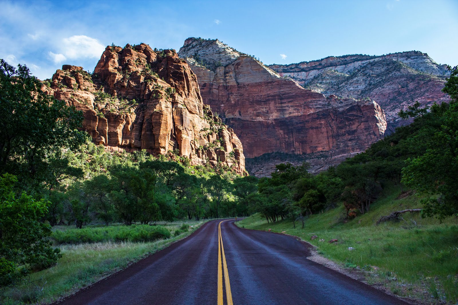
I drove my car to the East Rim Trail head in the afternoon – this is where I would finish the one-way trek. I loaded up my backpack with all my supplies; making sure to double-check I didn’t miss anything. I hitchhiked back into the South Campground, and stayed with a few climbing friends I had met there prior. Very conveniently, they were traveling to a climbing area very close to where I was starting the trail in the northwest corner of the park the next morning, and offered to shuttle me for free.
And the next thing I knew, I was waving goodbye to the grey SUV as I stood at the Lee Pass Trailhead. I breathed in deeply, and felt full of excitement as the entirety of Zion NP stood between me and the finish point. I checked out the sign at the trailhead, and it said something about drinking at least 7 to 8 liters of water a day. I thought that was kind of ridiculous, but still, I felt a bit apprehensive because I had only packed the capacity for 5 liters.

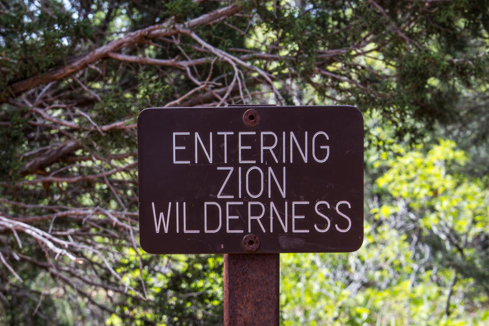


The first part of the trail descended pretty quickly towards LeVerkin Creek. A tiny sign read ‘Entering Zion Wilderness’ - a sign of good times to come. Along the way, I spotted many lizards sunbathing on the dirt; as well as some beautiful red flowers and cacti lining the sides of the trail. I had this invigorating feeling as I zigzagged between stunted junipers on the ridges, and dipped through luscious deciduous trees and creek crossings. Now, I’m no plant expert, but I was also seeing what looked like Aloe Vera plants with large twisted asparagus stems coming out of the middle of them. Regardless, the plants and flowers were blowing my mind. Drenched in dry dusty air, the red dirt beneath me provided a pleasant colour contrast. Above all the desert floor greenery, massive, red conical towers loomed with grandeur and beauty.

I encountered a handful of other hikers along the trail. They were all very friendly, and were surprised when I told them I had come all the way from Canada. I was following close behind one couple going the same direction when the girl screamed and jumped back. In the middle of the trail was a large gopher snake, which slithered off to the side when it saw us. She recovered, and started stepping ever closer to it to try and get a good picture with her cell phone, before both her boyfriend and I told her that she probably wasn’t being very smart and should step back on to the path. I meandered down to LeVerkin Creek to filter some water. The blueish white waters glistened brightly in the heat. After I filtered 2 liters, I remembered hearing the ranger say something about not drinking a particular water source because of agricultural runoff. I couldn’t remember which river it was. It started to worry me, and I checked the map for nearby springs to filter instead. I found one, labeled ‘Beatty Spring’. I figured I would filter out of that.
 Room with a view
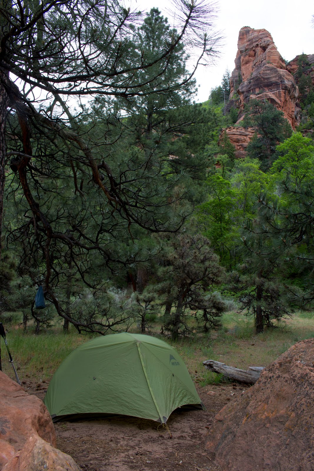
I arrived at my campsite number 10 after a short day of only 10 kilometers. I think it’s impossible to find a spot that is not insanely beautiful in the LeVerkin Creek valley, and site 10 was no exception. I was sheltered by a grove of large pine trees around my tent, with a nice proximity to the creek. Behind the tent was a small orange pillar, and across the valley, visible from the vestibule was an enormous orange cliff.
There was still plenty of time in the day when I got to the campsite (I think it was only mid-afternoon), and I was situated perfectly to hike to the Kolob Arch. I grabbed just a water bottle and a camera and headed down the short 0.5km trail. The sediment was almost pinkish along the way, and there was areas of sand so deep that it nearly went above my hiking boots. The walls were steep on either side, but instead of feeling boxed in, I felt sheltered by desert giants.
After coming down the trail for 15 minutes, I reached a sign that said ‘Further Travel Not Recommended’. And there was a trail leading straight up from this sign. So obviously you would ignore it and keep going – it’s not prohibited. The detour proved more than worth it, as I got an unobstructed view of the world’s sixth largest freehanging arch, which is 87 meters long. It was humbling to stand beneath this piece of rock, and gaze up at its sheer size. I was perched at a sort of centerpiece to a dish in the valley, and for nearly 360 degrees, dome-like walls surrounded me. They were so rich and red in colour that they seemed nothing short of unearthly.


I didn’t want to leave this special place I was situated in, but it was time to head back to the camp to start making dinner. After a minor detour to try and get closer to the arch through a small canyon, I turned around and hiked back.
Dinner was peaceful, as I boiled some water and added it to dehydrated potato slices with seasoning, simulated bacon bits, and cheese. The desert began to settle down, and a bit of Paul McCartney - Band on the Run played as the twilight drew on. But WAIT. I HADN’T FILTERED WATER YET.

Quickly donning my headlamp, map in hand, I went out on an exploratory mission to find Beatty Spring, which was supposedly only a couple hundred meters from the campsite. I stopped at the creek crossing before the trail started to climb towards the Hop Valley. Hmmmm…. It should be around here somewhere… I hiked up the trail a little more, until the next switchback. Still nothing. Okay, just one more switchback. Nothing. One more. Before I knew it, I was cresting the top of the pass, huffing and sweating. I started to worry a bit, as the next water supply wasn’t for a long ways. I descended quickly, and figured the worst case scenario was that I looked again in the morning, or just sucked it up and filtered out of LeVerkin Creek. Just as I got to the bottom where the creek crossing was again, I decided to turn left and go to a small little open spot. Sure enough, I found it. A beautiful clear running spring. I laughed and think I might have yelled Yeaaaaassssssssss! . I had clean water for tomorrow morning.
Protip: Beatty Spring is located just after you cross LeVerkin Creek to head up to Hop Valley. Just after crossing the creek , go right about 50 meters to find it tucked away behind some bushes. You do not need to go up in elevation – it is right level with LeVerkin Creek.
Now, I arrived back in camp relaxed and content. I stared up at the moon for a bit after brushing my teeth. I walked around the cold sand in my bare feet. The creek bubbled behind me as I got into the tent, brushed off my feet, and drifted off to sleep.
The next morning came bright and sunny; light came through pine needles, and the dry air tasted fresh with a bit of chill to it. I felt so refreshed and happy for it to be my first morning in the backcountry. I packed up my stuff and headed up the trail. It’s always a satisfying feeling when everything you need to survive is on your back, and you just kind of turn away from a spot and start walking away; it feels very nomadic.
I filtered a full 5 liters of water from Beatty Spring first thing, and then started up Hop Valley Pass, feeling very hydrated and ready for the day. I passed a group of hikers in a stand of pine trees. We recognized each other from the Visitor Center when we were getting our permits; I think we were both a lot more relaxed on the trail. I continued over the pass, and descended into the Hop Valley.
The Hop Valley has a comforting aura. In the middle of the valley, there is a large, flat flood plain, which is mostly sandy with some grasses. Up on either side was the standard Zion cliffs, but these ones weren’t quite as big, and were more vertical and continuous, rather than broken and overhanging. I think I was the only one hiking through the whole valley at that point; the other groups behind me now. It got really windy as I continued down the valley, but I was already used to it – the wind had been blowing the whole night before too. In fact, it cooled me off, and I welcomed the wind as an elemental companion, along with the trees and rock.

 Black-headed grosbeaks sang from the willows by the creek – I passed in and out of private property signs and emerald green fields of grass. Up ahead, I noticed a dog-like creature walk across the path. I squinted to get a better look at it, and it turned out to be a coyote, traversing its way through a gulley. It stared at me, and I at it, before we exchanged a mutual nod, so to speak, and we both continued on our perpendicular paths.
Shortly after seeing the coyote, the trail started to climb… and climb. And it just kept climbing. It was a huge elevation gain, and I had to stop halfway up because the heat and the grade were getting to me. I kept plodding on after a sandwich, and reached the top of the plateau.
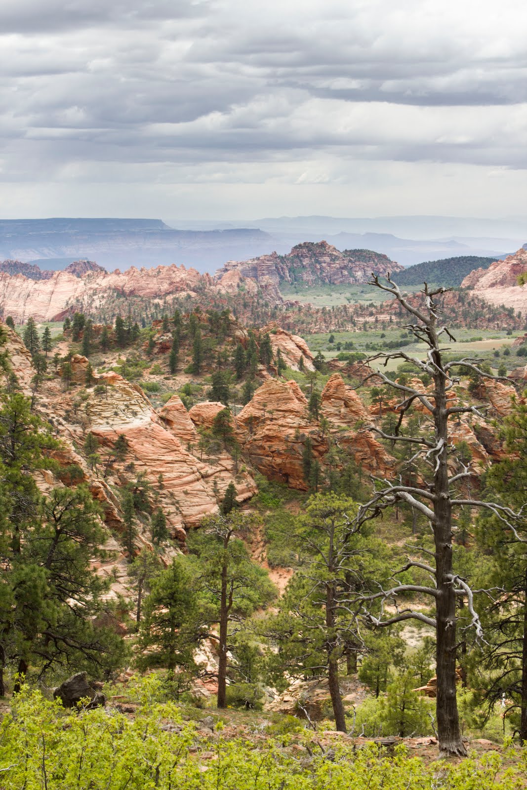
 It’s crazy how the flora and geology changed so quick when I crested the rim. Sagebrush covered the ground, creating a turquoise field of colour, and small blobs of orange rock dissipated to undulating hills and long distant mesas on the horizon. And it was flat, which meant easy hiking for a good distance. I snaked in and out of the sagebrush, and came across a party of 3 hikers – Chris, Tom, and Chloe. I didn’t know it at the time, but we would end up leapfrogging each other down the entire rest of the trail.
There’s a small trailhead at Hop Valley parking lot, but there was no water (only pit toilets), so I continued on. To connect to the next day hiking trail, you sort of have to cross a few rural estates, and trend near some quiet roads. It wasn’t bad though; it was very open, and the whole way, I was captivated and humbled by the absolutely expansive view off to my right. The land dropped off to distant desert everywhere, quite literally as far as the eye could see. Pillars, canyons, trees and brush made it seem like a painting everywhere I looked.
Mid afternoon was dwindling on, and the humidity and heat took an effect on me. I sat down for a few minutes, lay back on my backpack, and felt pretty beat. The sky had clouded over, bringing with it a sense of groggy daytime stillness.
The trail started making its way through denser pine forest, and with a spooky deepness, I heard and felt a deep thunderclap reverberate among the trees. This change of atmosphere was fantastic. I passed Chris, Tom and Chloe, and then they passed me as I sipped some water. We had nearly the same pace; but when I was getting too close to them, I would hang back for a minute – having just myself and the thunder was exhilarating.
I turned off the trail at Northgate Peaks, thinking that that’s where the camping was at Wildcat Canyon. I had been assigned an ‘at-large’ spot, which basically meant within a specific area, you could camp wherever you found flat ground. It turns out that Northgate Peaks is most definitely not Wildcat Canyon, so I had to backtrack to the main trail, and continue on.
I could smell the rain before it started coming down. A bit a of a cold breeze hit my face, and large blobs bounced off of bone dry dirt. Slowly, the drops created a continuous dark layer on the ground, and the intensity grew. While the rain transitioned into a steady pace, I was descending along a straight but bushy cut down into Wildcat Canyon. Most of the way, the view was blocked by bushes, but the odd time, there was a glimpse of the canyon walls. They were this white, chalky stone, in a visible state of erosion. They were sloped and cracked, and with the impending fog, they seemed quite mystical.
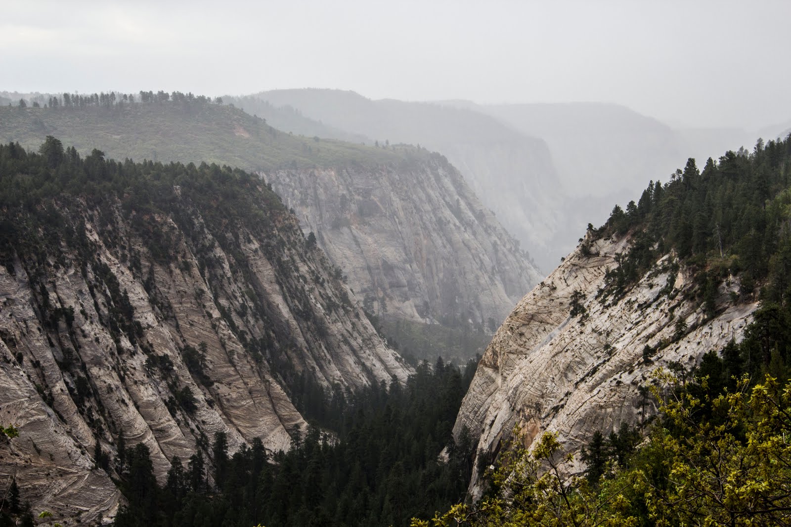 Maybe it was just the rain, but it sure felt like a different microclimate in the canyon. It was noticeably cooler, the vegetation was different, and the rock was different. I checked my altimeter. Still near 2150 meters.
I found a small stream to filter water out of just before the bottom of the canyon. As I walked along the canyon bottom, I started looking for tent spots, and was unamused by the prospect of camping beside some other tents in a slightly slanted clearing among trees beside the river. I continued on, and started to slowly gain elevation. I realized that I was leaving the canyon altogether, and I needed to find something. The problem was that the trail was almost the only flat clear section – everywhere else was heavily treed or really slanted.
Then I saw it. The smallest flat spot just off of the trail. I hiked up about 10 meters on a steep embankment, and sat down on a reasonable platform of land. It was probably still sloping five to ten degrees, so it definitely wasn’t ideal, but there was a section just big enough for my one person tent to fit. It had the nicest view of the canyon I had seen yet. I jumped on the opportunity, and set up my tent. The rain thankfully had stopped while I did this process. Just as I had gotten inside, however, the pitter-patter started again on the tent fly, so I brought everything inside the vestibule and sat there, listening to music and wishing I’d brought a book. It was only 6 pm at this point, and even though I was completely exhausted from hiking, I wasn’t ready for bed yet.
The slope was so bad for sleeping that I had to stack every single spare piece of clothing I had brought under the left side of the thermarest to prop myself up to be somewhat horizontal. Without the bracing, I would nearly roll down the slope and fall into the side of my tent like a hammock. It was definitely not ideal as I lay there at 7:30 pm. At least I had had the luxury of a quick and easy dinner – powdered food mixed with water. Mmmmm… the recommended portion was one scoop; but I took three. Hey, a hiker’s gotta eat.
 Of course, the rain stopped eventually, and the sky cleared. Beautiful, if you like clear sunsets, but awful if you are in a high elevation canyon on the side of a hill with a 0 degree Celsius bag. It got cold real fast. I watched the sun set for a few minutes, perched on a small flat rock, and then headed in for bed. I wore all my jackets, zipped up the sleeping bag fully, and put the hood on before finally doing up the drawstring around my face. I was still cold.
After half an hour of shivering, and wondering what the hell was happening, I realized that my t-shirt was still damp from hiking in the rain, so I stripped down to bare skin, and put my fleece on instead. I went back into my sleeping bag, and was immediately much warmer. It just goes to show how much being wet can really kill you in cold situations.
In the middle of the night, it was dead quiet - everything was so still, and I subconsciously listened to a Whip-poor-will calling, and a Northern Saw-whet Owl hooting in the dead of the night. I was in a foreign land, but even though I had only been here about 5 days, I was already started to feel entwined with the dry air, with the desert plants, with the unique wildlife, and with the desert cliffs.

It was one of those mornings where you just want to start moving. I had woken up with my entire body pressed into one side of my tent cause of the steep slope – and I was still kind of cold and uncomfortable. So I skipped breakfast, chowed down a bar really quick, and began hiking. Dew coated all of the vegetation as I ascended the trail out of the canyon. The sun was peeking between bushes and clouds, but it wasn’t quite ready to make an appearance yet.

I ran into Chris, Tom, and Chloe again as I came out of Wildcat Canyon. There was a small parking lot here for access – no more than a glorified patch of sand, and they were waiting for a friend to join them. Up here, the landscape was mostly flat again, and I passed a few old metal wagons, telling stories of ranchers come and gone. Small 10 meter cliff bands were brown and black along the horizon, like someone took a blowtorch to the red cliffs I was accustomed to. Clouds darkened the sky. Overall, it gave a spooky vibe. I liked it.

The next part of the trail was a famous and popular section – the West Rim. I hiked with a quickened pace for half an hour, and I cracked a huge smile as the sun burst out from behind the parting clouds. It started to get hot, and I unzipped my pants into shorts, took off my fleece, and slathered on a layer of sunscreen to my browning skin. I moved off the trail until I found a huge log. I happily spread my life out before me, and began preparing breakfast. I felt so good – big pine trees and the sun were creating that smell that wafts through any hot forest – a strong sweet smell of pine sap, of needles. My oatmeal never tasted better. With a cinch of a hip belt, I bounced back to the trail and skipped down the trail, whistling as I went.
I was in the flow now. The “flow” is that sacred moment when you feel so good and confident with where you are in the present, you can glide along as if you are putting in no effort at all. I darted through the forest as the trail made S curves, and took on steep inclines with a few big breaths.
A couple hours ticked by, before I made my way over a large rise in the trail. Out of nowhere, I was greeted by possibly the most spectacular scale of erosion I had ever seen. Towers of white sand stood before me. To describe these towers is hard – because their scale, shape, and colouration was that of complete marvel. One tower looked like someone had built an unrealistic cube in the game Minecraft , hundreds of blocks high, then made it completely flat on top, planted trees and grass on the top, and called it a day. Another tower resembled a great pyramid with rounded corners. Bands of red were separated in stark contrast to the prominent white. I blinked a few times, and thought to myself, “Okay this is how people discovered geology.” Like, it was so obvious how the plateaus used to be connected, but were worn away in deep gullies between the towers. I could feel the scale of time, and see the scars the rivers left. I took off my pack, pounded back some water, and ate a sandwich, still kind of dumbstruck.

Aloe vera plants lined the edge of the rim, and right behind them, the trail wound its way 5 meters from the edge. To my right were the towers, ever present in their monstrosity. Small pink and white flowers and cacti dotted my every step. Finally, after an extended period of time, the towers passed behind me on my right, and I was back in the pine forest with a limited view of the distant desert. I was nearly at my campsite. I was thankful that my day would be over soon, but also was a bit unimpressed, because it was only 1:30 pm.
I heaved my backpack to the ground with a solid thud. I was here. This campsite was once again absolutely incredible, with a pretty good view of some more canyons out to the South. There was a large flat spot by a tree, and I quickly pitched my tent. It seriously felt like a hotter day in August. I wouldn’t be surprised if the temperature was 31 or 32. The sun beamed down its rays. Okay, so this was May in the American Southwest. I texted my dad to let him know that I was alive and (very) well.
Now I had the luxury of spending the rest of the day relaxing, since there wasn’t really any side trips nearby. I walked around camp, hung some stuff up to dry from the night before in the gusty wind, and gave my toes a rest by walking around without shoes through the pine needles. I laid on a log for a bit. I played “Band on the Run” again – it was definitely my theme song for this trip. I paced back to my tent. I laid on the log some more. Okay, I was getting bored.
That’s the only downside of doing a solo backpacking trip, is that you eventually want some company – just someone to chat with, or throw some rocks around with. Any companionship, really. Something to keep your mind occupied. It’s not bad when you’re doing things, but when you stop, it gets a bit lonely. So to keep myself amused, I wandered down the slope from my tent until I found a killer view point. I planned to come back here at sunset.
I had brought an extra dehydrated meal in case I had to spend another unplanned night out in the backcountry. Tonight was a special night, because it was my last night, or in other terms, my last dinner in the backcountry. I would not have one meal tonight, but two. I rubbed my hands together excitedly.

Round one began with mashed potatoes and soup – a huge carbo load and a Kris camp classic. There’s not much creativity to it really – but it is super filling and delicious, two qualities that make any wilderness meal a delight. I quickly polished the entire pot off, and it was time to begin round 2 – Backpacker’s pantry Pad Thai. It’s arguably the best one of Backpacker Pantry’s creations (no I’m not sponsored), and it has the highest calorie count. So yeah, once again, filling and delicious. Needless to say, I had been awaiting it the entire trip.
I opened the bag, and pulled out the satchel of peanut butter that comes with it. I don’t know why, but I tried opening the peanut butter packet while I was still holding the bag of Pad Thai. Like something out of a horror movie, I gasped as my hand slipped and the bag spun completely upside down out of my hands, landing perfectly face down on the ground. I actually sat there for a few seconds in trauma, my mouth open and my eyes wide.

Not that I was following the 5 second rule, but I reacted pretty quickly, and turned the bag on its side to salvage any Pad Thai that might be saved. About three quarters of the meal lay in the sticks, dirt, and dust. I let out a yell after the initial shock had gone away. I lay the lid of my pot out on a rock and started to collect the noodles, and pieces of seasoning. I grabbed most of what I could. Then I meticulously went through the mess, and one by one, pulled out any piece of dirt or wood chip that looked brown, to distinguish from the seasoning.
I cooked the meal, but as I was cautiously chewing, I would get more than a few bites of what I knew was bits of wood. I literally a moment where I had to convince myself that I was eating 'organic pine' to make myself feel better about ingesting ground bits.
After the trauma of the Pad Thai, I went back to my viewpoint to watch the sunset. It started off gold and white. As the sun descended further, a couple parties of hikers went past on the trail 50 meters below my campsite, and I sat on a rock, crouched, watching them like an owl. A little weird but I didn't honestly care at this point. It got quiet as it got darker, and pretty soon, the entire sky illuminated pink, and the desert towers were this calming shade of purple. I thought of rivers, and of time. The slow process that wears this landscape down; and the special presence of life here in the desert. Paul McCartney words drifted across the sand from my tinny phone speaker - "the night was falling as the desert world began to settle down.. in the town they're searching for us everywhere - but we're nowhere to be found.."
I was being very silent and thoughtful, and before I knew it, movement caught my eye. A deer was casually browsing away at bushes and herbs. I watched it for 5 minutes as it meandered by my campsite. It was nearly dark. I opened up a memo note on my phone and wrote down a few words:
Like the desert shifting by,
Towers grow as rivers wind.
Pink and blue paint the sides,
Of sand and rock, eras goneby.
A single doe, browses by,
Shining moon and twilight sky.


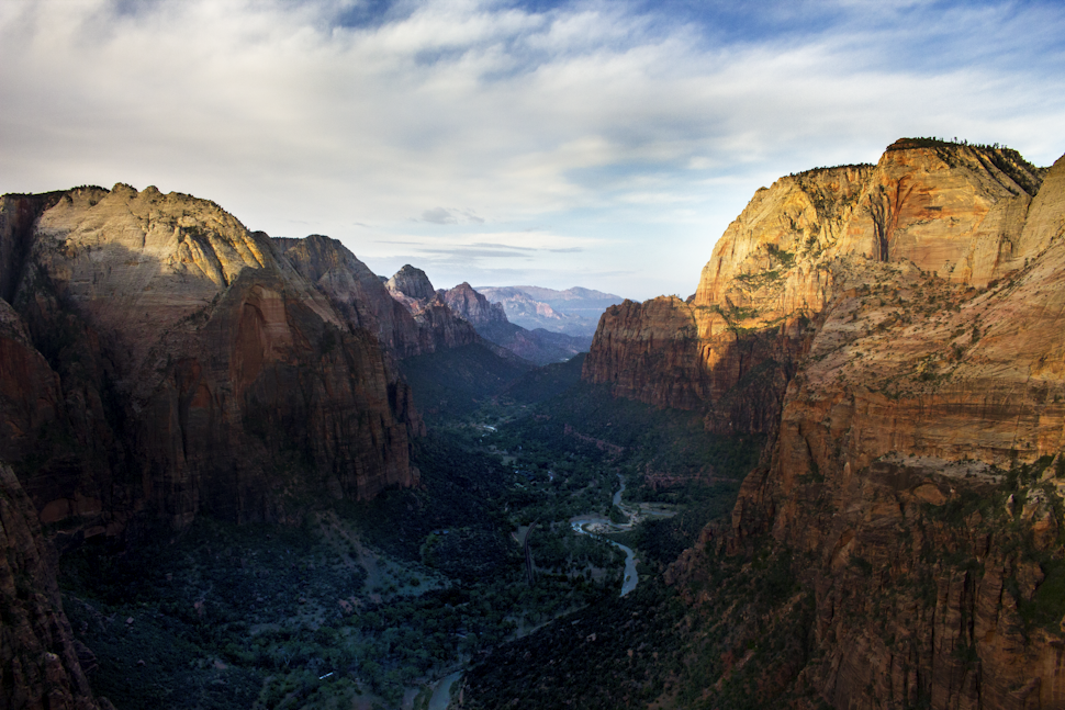
I went to bed early, because I knew I had a big day the next day. I was planning on hiking down the last of the West Rim Trail, making the detour to Angel's Landing trail, and then hiking all the way down to Zion Canyon, nearly 700 meters of elevation loss. Then I would hike through the canyon floor for a few kilometers, and begin the arduous trek up Observation Point trail, up the other side of the canyon, gaining my 700 meters back. Finally, I would hike through Echo Canyon Pass, and finish the East Rim Trail, taking me to my vehicle and the end of the Trans-Zion Trek.
I was up at 4 am. Somehow, I wasn't tired at all. It was pitch black, and a strong wind buffeted my tent. I tasted dust in my mouth, and sand seemed to be in every part of my sleeping bag and tent. I exited the vestibule and mad a quick brew of hot tea and oatmeal, which warmed me up nicely. I quickly and neatly packed everything up, while placing large stones on my stuff so it didn't blow away. I applied a quick layer of sunscreen for the day, then I proudly looked at my pack and hoisted it up on to my back. I decided to start hiking in my shorts, and a fleece. I pressed the top button on my headlight, and I was off.
My skin was brown under a dark sky. Every part of me was covered in fine dust. I hiked quickly through the dark trail, making short work of switchbacks leading me slowly downwards towards Angel's Landing trail. My little bubble of light shone through the thickets of dark trees. I kept thinking in my mind that if I was lucky, I'd be the first person up on top of Angel's Landing, before the tour buses shuttled hundreds of other people there; all ready to do the best day hike in Zion.

The moon subsided to give way to the palest blue and yellow light you can imagine. I snaked through white cliffs. The rock gave off a comforting greyish blue tone, and I felt the world gaining light. Birds started sporadic calls amid the morning chill; which was wearing off - it was probably already 15 degrees Celsius. Sweet smells of juniper greeted me every time I breathed in. I scared two deer and they bounded away from the path.
I had this burning happiness and excitement as I reached the start of the side trail for Angel's landing. It was only a 2 kilometer round trip diversion, but it was just about the best two kilometers one could think of - hiking along a knife-edge ridgeline with a 500 meter drop on either side.
I hid my big hiking backpack in some bushes, and detached the top of it so I could bring only my water, a snack, and my camera to the top. I grinned; no one was here. Like a kid running through an amusement park, I bounded up the trail, which was guided by big metal poles and chains. I made a stupid challenge to myself to not use these on the way up; partially due to pride of being a climber, and partially just cause I like to not conform sometimes.
My jaw dropped as I crossed a particularly narrow section at one point; there was the chains, a small step (some have nicknamed it 'the step of faith'), and pretty much nothing else but sheer death on either side. (Okay, I might be making it sound scarier than it was, but I have to hype this trail; it's worth every step.)


As I crested the summit of Angel's Landing, I was actually shocked to see a couple already sitting up there. I asked them how they got here so early, and they told me they actually road walked all the way up the canyon for a couple hours before dawn - just to skip the lineups like me. Wow - dedication. I gave them props, then found my own quiet spot to sit and watch the sunrise.

Like magic, the canyon woke up. Sun illuminated the walls with a vivid gold, and I watched tour buses slithering up the road at the bottom of the canyon, which was still engulfed in shade.
A breeze blew past. I felt on top of the world.
Before the hordes of people trekked up the side of the canyon to the start of Angel's Landing ridgeline, I was already hiking down, passing a nude photoshoot??, and grabbing my stashed pack.

I practically bounded down as I lost tons of elevation. I started passing ten people, twenty people... fifty people. I nodded at each and said hi at first, but then I realized that I was back in civilization, and it wasn't really a special interaction each time you passed someone on the trail. I put my head down and continued down the carved cliff-side on the massively wide engineered path.
Before I knew it, I had hit the canyon bottom again. I was staring at a sign about Angel's Lading when I realized that it mentioned more people had died, than the sign said at the top. Huh. Interesting. I grimaced a bit and carried on.


It felt a bit odd to hear the motorized sounds of vehicles driving past me as I walked down the road. I filled all my water bottles from the water tap generously provided by the NPS, and used the flush toilet bathroom with running and water and soap. What a delight. Except for the huge spider on the floor.
I walked on the opposite side of the road, as tourists gawked out windows of shuttle buses at me with my hiking poles and huge backpack. A few wild turkeys crossed the road, before disappearing in the dense bush undergrowth and large cottonwoods by the Virgin River.
I felt insanely full of energy as I reached the other side of the canyon, and started the 700 meter elevation gain up the Observation Point trail. Even with my heavy backpack, I was in the flow once again, and somehow managed to pass people without backpacks going upwards. (This prompted a few scolding glances and sarcastic remarks.)
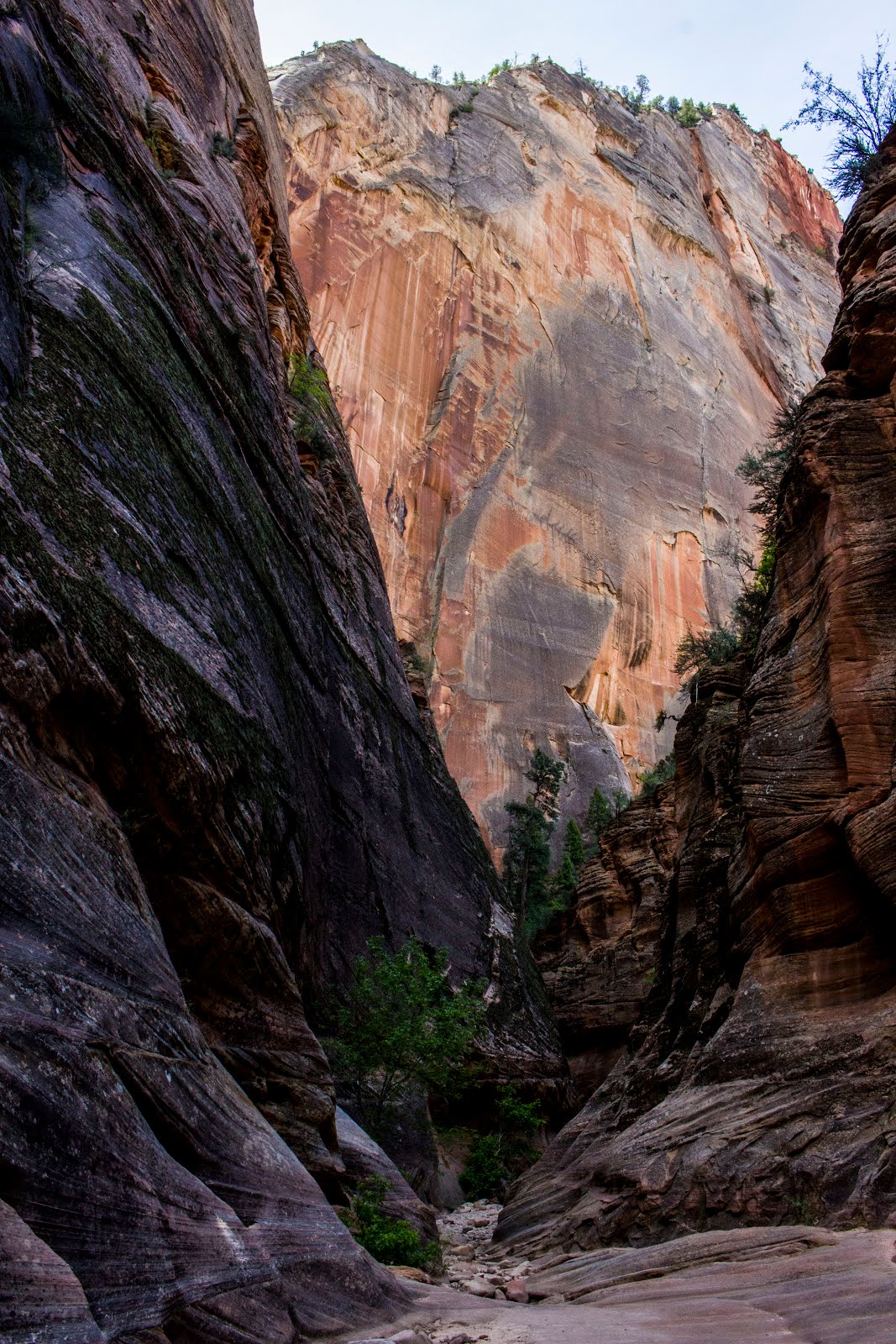 One of the biggest cliffs I had seen yet was looming above me as I entered the Echo Canyon pass. It's this narrow 'slot' canyon I guess I would call it. There's about 50 meters below you of dark twisted reaches. The trail sort of winds around these scary crevasses, but is by no means at the top of the canyon either, as big walls surround you on either side. It's a super cool environment, and I highly suggest going there, even if just for a day hike.


As I reached the end of Echo Canyon, I turned right onto what would be the final stretch of my Trans-Zion Trek; the East Rim Trail. It was here that I felt the fatigue kick in. I had already hiked over 20 kilometers, and I still had over 10 kilometers to go. I had a few sessions of just sitting at a viewpoint, while laying on my backpack.
At one point, I literally watched a Peregrine Falcon launch itself from a tree, stoop downwards, and dive at what seemed like over 100 km/h to take out a small bird in a cluster of feathers. It was a sight to behold, and I was thrilled to see it in person, because I had just written a 20-page paper about the Peregrine Falcon a couple months before in school.
I rocked back and forth, holding my shoulder straps as I carried on upwards through the East Rim Trail. The sky had clouded over, and I was sort of deep in thought when a person running with a big backpack startled me.
"Hey man!"
I realized with a smile that it was Chris - the guy from the group of three hikers I had met way back on the trail. He told me that the other two people in his party, Tom and Chloe, and decided to call it quits at the bottom of Zion Canyon, but he wanted to finish the trail, so he was almost running it to beat them back to their car at the East Rim trailhead.
It was just the motivation I needed, and we set off together down the trail. He talked about living in Utah, and I talked about living on Vancouver Island. We both loved climbing, so we instantly hit it off, and before I knew it, we were nearly back at the top of the plateau, and done the 700 meter elevation gain.The only problem was that he was going so fast, at a near jog, that I let him go on his way after awhile. I wanted a more relaxed finish.

I stopped at a really quiet part of the plateau. It felt like I was back in ranchland. The cliffs were white and smaller everywhere, and I passed a guy with cowboy boots, a cowboy hat, and jeans. I applied some more sunscreen, cause even though the sun was behind the clouds, I could feel my skin burning while I hiked.
I ate my last peanut butter sandwich at a junction, drank nearly a liter of water, and walked through the wooded lands of the mesa, deep in thought. I was satisfied, and happy. I thought of the past 4 days and jotted down a quote:
To walk in the wilderness with friends,
Is an act of bonding and connection.
To walk in the wilderness by yourself,
Is an act of discovery and reflection.

I turned the last couple of bends around the East Rim Trail, and crossed my finish line in a very calm state. My fears of the Highlander being stolen or having its windows smashed in were instantly gone as I saw it proudly sitting there in the sandy parking lot. I opened the trunk and cracked a warm can of beverage to celebrate.
I have to say, this was one of the better backpacking trails I have ever done. The amount of diversity was indescribably vast. Every turn gave new atmospheres and biomes. I saw sights I may never see again; I may have seen birds that I will never see again. But it was humbling and beautiful every step of the way. The desert now holds a special place in my heart, as it does for all of those who traverse its secret canyons and towers.

We want to acknowledge and thank the past, present, and future generations of all Native Nations and Indigenous Peoples whose ancestral lands we travel, explore, and play on. Always practice Leave No Trace ethics on your adventures and follow local regulations. Please explore responsibly!
Do you love the outdoors?
Yep, us too. That's why we send you the best local adventures, stories, and expert advice, right to your inbox.


