
"Beyond Limits" A true story of planned serendipity.
Your teenager should read this 107 page story of my hikes in the Sierra Mountains. He/She will jump off the couch and ask to go.
BEYONDLIMITS

BEYOND
LIMITS
JimmyBugert
Editedby Mary Beaverson and Bob Johnson
♥
KathyBugert Publishing House and Home Ink. ♥
BeyondLimits. Copyright © 2016 by The Jimmy Bugert Vice PresidentialLibrary Foundation. All rights reserved. Of course like everyonelately I'm claiming more and more entitlements every day too so watchyourself!.
PrintedDecember 2016 in my basement. Thank you Brother.
FiveHard Bound Copies are made for immediate family because I suspectdemand will be low if not non existent.
Nopart of this book may be used or reproduced in any mannerwhatsoever/herewith without written permission from Kathy except inthe case of brief (under 1,000 words) quotations embodied in criticalarticles and rave reviews of the author. If you are going toelaborate on any thing positive, let her rip and I'll swear it istrue. For information, address Jim Bugert 1923 Red Oak Run, FortWayne, Indiana 46804. 260-402-7042 If ya call, leave a messagebecause I get so many Credit Card calls I tend to block numbers who Ihave no idea who the heck they are, know w' am sayen?
KathyBugert Publishing House and Home Ink. Books may be purchased forinsomnia, educational, or sales promotional use. Suggested retailprice $1,000. Wholesale is the same. Don't be cheep.
Lastedition
Designedby Mother Nature with help from Sara Ann Dipity
Libraryof Congress (I hate to use that word) Cataloging-in-Publication Datais available upon request. Pleasebe patient as I really do not know what that means.
ISBN;978-0-06-0876005
ISBM-10:0-06-087600-X
^Lookthat up you'll be surprised
MMXvi
♥
ToKathy Bugert
♥
Contents:
Dedication...............................................nextpage, you'll find it
Acknowledgments.................................................................iiix
Forward....................................................................................8
Backward.................................................................noneexists
Author'sNote...........................................................................9
Chapter1 The FreshestAir...................................................12
Chapter2 ConceptSpark.....................................................13
Chapter3 Research.............................................................18
Chapter4 FoodPreparation.................................................24
Chapter5 Equipment Preparation........................................27
Chapter6 Physical Preparation............................................30
Chapter7 Lean onFriends...................................................31
Chapter8 DetoursTaken......................................................38
Chapter9 TreadLightly.........................................................47
Chapter10 Attack this Mountain Lion Trail from Her Flank?? I askedmetaphorically........................................48
Chapter11 Fate on MySide.................................................49
Chapter12 Getting Ready to be Ready................................53
Chapter13 Base Camp Whitney...........................................55
Chapter14: Getting to Base Camp Before My Summit.........56
Chapter15 Final Ascent Day aka: Can I Tackle This MountainLion??...............................................................61
Chapter16 Short Run down this Little Hill ….......................67
Chapter17 Sunday Luck in Owens Valley after Coming Down from theMountain...................................................71
Chapter18 RV Park Rest after the Mountain and Home......77
Chapter19 Personalities IMet.............................................81
Glossary............................................................Lookfor yourself
Index.................................................Thereisn't any, just reread
Thisbook is dedicated to:
Myancestors who through natural selection provided me a body thatallowed this hike.
ALLour offspring whom we hope will be inspired to repeat this hike forevery generation to come.
Acknowledgments:
Iwould like to mention a few marvelous friends who were particularlyhelpful in the preparation of this book and hike. They include, butare not limited to: Bob and Jan Johnson for their unflinching supportin the forest fire ravaged mountains of California, Kimchi Chan whogave me a purpose for pushing that last leg, Bob Palmer for plantingthe seed to do the PCT, and adding an appropriate mood settingprovocative quip: “Adventure is worthwhile in itself. The mosteffective way to do it is to do it.” Our nine grandchildren whosewords and art work gave me daily fuel, Kathy for understanding ''itis a guy thing'', and my Mom and brother Bob for instilling in me astrong sense of adventure and positive attitude. My brother Joe forteaching me to deal with adversity, adapt and adjust. My sister Maryfor her time and talent in editing the words and flow herein. Ourfavorite son David for his book title suggestion.
Ithank everyone who took the time to send me constructive comments butwhose names are not mentioned here.
Ithank my high school classmate Cheryl Mowen for her kind words ofencouragement and congratulations. She pointed me toward a verytalented mutual friend Barb Sieminsky. Barb's very hard professionalwork to place my efforts in a good public light by publishing herSenior Living article before I left and the News Sentinel articleupon returning were amazing. My guardian angel for her safety net,guard rails and stitches through life. I also want to thank myclassmates and teachers who during grade and high school always heldme to a high standard of achievement. Belonging to a class ofoverachievers was difficult at times while I put down deep roots tobloom much later, but in the long run every one I ever met, and manyI never knew were blessings of more natural grace from God our mutualFather. Thank you all ♥
Forward:
Everyoneshould have Jim Bugert in their life. He is one of those people whomake you feel good about the human race. Filled with hopes anddreams, Jim doesn’t just talk the talk, he walks the walk!
Everythingfrom volunteering with CASA and the Red Cross, helping rebuild in NewOrleans after Katrina, to helping a school/orphanage in Haiti, Jim isthere. In between, he finds time to spend with his children andgrandchildren, make amazing things out of wood in his basement andeducate himself on the happenings of the world around him. Oh, anddid I mention that in addition to everything else he does, he somehowfound time to teach himself to play the harmonica? And that he isnow working on learning the clarinet? He also writes his own music,is active in the local music scene, and takes a yearly trip out westto explore and hike in the desert southwest. This book is about histrip west in the summer of 2016.
Ifirst met Jim aboard the U.S.S. Topeka CLG8 in 1968. We servedtogether in the Navigation Division on the Topeka for close to twoyears. Little did I know we would still be friends almost fifty yearslater.
Aftermany years of no contact, the internet brought us back together in2004. After him telling me about his life for the last forty years,and me telling him about my life for the last forty years, it was ifwe had never been out of touch. I look forward to his pithy emailson about every subject and he never fails to make me smile. So whenhe told me about his plan to hike along the Pacific Crest Trail near(in California 200-300 miles is considered near) my home inCalifornia, I offered my support. Actually, I offered to be his Uberdriver! He accepted, and started planning what would be a veryinteresting adventure. I’m glad my wife Jan and I were a part ofit, and I think you will find the story of his trip a worthy read. Enjoy!
Bob(Johnny) Johnson
CampNelson, California
November1, 2016.
Author'snote:
Chronologymap to this crazy mixed up book.
Rightnow I bet you are wondering how did an engineer of 71 years old getmixed up in a place like this? Let me tell you a little story. Thisis my first official book and quite possibly my last, so you will nowhave to try and understand that there are two halves of my brain thatyou'll have to contend with while reading this. The left brain islogical and if I wrote only with that half you would be bored becauseI would take you in a very non-artistic route from A to Z with nodetours. Booooring!! If on the other hand I use the right side of mybrain which frankly I am trying hard to develop since I've retired,you'd be so confused you wouldn't know if I was on the Antarctic orthe North pole, let alone know what country or state I was in.Confusing!!! So I thought that this would be a good place to at leastgive you some sort of a map in order to follow what I think of asflashbacks in a movie. You know, when you watch a movie sometimes thefirst chapter or the first scene is a hook to get you interested insitting through this 2 1/2 hour movie. In a way that is what I amdoing here. But not being a seasoned Hollywood director let alone apoor writer, (I usually got D's in Literature and Englishcomposition), I will give an overview and an outline of my story inthis section. If you get lost later for instance in Chapter 10 youcan come back here. These are the breadcrumbs for you to follow.
Chapter1 actually takes place about 80% of the way through my trip. ThisMountain hike was not at all planned in detail as most of the PCTwas. My planning started with Chapter 2 which I call Concept Sparkand is intended to give you an idea of the chronology of my thoughtprocess and the actual physical movements. I have always said that80% of the fun of any trip is in the planning. Chapter 3 is theresearch which came before the trip and the Lean on Friends chapteris my attempt to explain to you how important it is to make goodfriends each day of your life. Chapters five and six are all aboutthe preparation and quite frankly are somewhat boring to me but Ihope are nonetheless helpful to you so that when you do the tripyourself you will be fully prepared. I then get a little artsy-fartsiand throw in a short chapter of a reoccurring thought that kept goingthrough my mind after being out in California for about two or threeweeks; again just another hook to keep you interested, called AttackHer from the Flank?
Soto recap here a little bit and give you an even straighter line. Ibegin the book with an opening chapter of my day up on the mountainand go back to how I came to plan this trip. The maps and foodpreparation and all the studies and books that I read to know exactlywhere the Pacific Crest Trail was. After having bought all theequipment that I needed I packed it and jumped a train from Indianato Southern California. My Navy buddy Johnny picked me up. It wasthen that I realized that Tehachapi Pass was way too hot and desolateso instead I started my actual hike at Agua Dulce, ca. about 75 milessouth of there down around Santa Clarita. That too was a disasterbecause it was not only too hot for me but many of the forest firesin California were either blocking access highways so that I couldn'tbe resupplied or were blocking my actual Pacific Crest Trail. Bobtook me back to his home in the mountains at Camp Nelson Californiain the Sequoia National Forest where he has lived for several years.There I was able to re-plan and acclimate to the 4,000 foot altitudeand wait for the fires to abate. However, after a week of that Istill had no good accessibility to the Pacific crest Trail so wedecided to take a trip to the coast and enjoy some of the morecivilized areas of Southern California and plan my next attack. Thatwas when I visited Morro Bay and the Hurst Castle. After helping Bobplant some trees and reconfigure a new light weight pack Bob thendrove me to the base of Mount Whitney which is the highest mountainin America's lower 48 states. I had climbed to within eyesight of thesummit. This is where I first met Kim Chi. That was not at allplanned. The actual hiking of the Pacific Crest Trail which I socarefully had prepared for back home was not to be this year. After Iclimbed the mountain I hitchhiked down to Lone Pine and that was onthe Sunday of the bar scene before Bob picked me up to camp thatnight near Lone Pine. Then to make a long story short rather thantake the train back home we drove up near Lake Tahoe and visitedSilver Lake, saw burned forest areas and I flew home on Labor Dayweekend. I had hoped to do the train back through Salt Lake City andDenver but the next available seat was five days away due to LaborDay travelers having booked early. They must not have a life! Withina day I began to write this book. Hopefully that gives you a niceoverview and you can come back here if you get lost around chapter10. Hope that helps.
Seethe last page for descriptions of photos. I wish you could have beenthere with me to see, smell, touch, hear and taste them all.
BEYONDLIMITS
Chapter1
TheFreshest Air
Oursuns were too bright! There had to be more than two of them. Did Ijust have my eyes dilated and sent home without sunglasses? Was everymolecule of pollution and breathable air vacuumed out before we gothere?
Sunrisewas 5:30. The moon had been up while we slept at base camp lastnight. The snow lights hit us from every angle. The ridge notch nowallowed the Western vista and its prevailing westerlies to stimulateour senses although that overload was not really needed. She and Ihad climbed to 13,650 feet relying on each others sustenance. Kimchiwas getting sicker and up until now had given me purpose. Up til nowI had given her strength.
Thosemany months of my planning and these final last hours of shiver thensweat were worth it. We were in heaven now and heaven was within us.
“Jimmy?”Greg asked. “Where are you?” “Greg, Jimmy, at Trail Crest.
Whereare you?” “About a half hour from Summit, a bit confused butthink I was back there two hours ago. Average hikers are making thelast 1.8 miles in two and a half hours. The trail gets better withless snow but the oxygen is all gone” Greg panting all the while...
At71 I'm no lung on legs. I see the view, I feel the rush, my feet arefinally on steady boulders but my face is fuzzy. Kimchi's headache isnow a dizzy gut-ache with sleepy and sad emotions. When I met herfive hours ago this 27-year-old Vietnamese's spirit shined bright andonly needed my company. Now she needed pills, water, oxygen and home.Very very strong she is but life up here can be hell.
Chapter2
ConceptSpark
InJuly of 2013 my best buddy Bob Palmer discovered something which hadplanted the seed that now flowered in my heart. The Pacific CrestTrail in Oregon had caught his attention and the visual descriptionsof it to me stimulated some hormones laid down by my grandparents. InAugust of 2013 Bob hiked in the Willamette National Forest justoutside Eugene Oregon and it was his first realization that there wassuch a place or trail called PCT The McKenzie River trail. His friendJulie's uncle Jerry had hiked some of the PCT and Bob told me aboutit's existence upon his return home. He found no bugs which hasalways turned me off when thinking of northern trails in Minnesotaand this wet Oregon weather never had appealed to me. He said thepaths made him feel good and you just want to hike to the next turn.Then the next turn.
Icopied this from the USDA website: With over 1.5 million acres, theWillamette National Forest is home to eight wilderness areas,including the popular Three Sisters Wilderness and Mt. JeffersonWilderness, a variety of backpacking and day hiking opportunities,waterfalls, wildflowers, mountain biking trails, boating, swimmingand much more! The varied landscape of high mountains, narrowcanyons, cascading streams, and wooded slopes offers excellentopportunities for visitors and make the forest valuable for manypurposes.
Halfof the enjoyment of going west since I retired at 60 has been inplanning and preparation. Bob stumbled upon this and I stumbled inafter. By now you would think that I would have learned the lessonthat "Plan A'' never works out but no ,,, I'm a hardheadedGerman. You will see later how I scrapped Plan A and went to Plan Z
TheNix and Bugert families originated in Germany and brought much withthem and freely gave much to me. That stumbled upon seed germinatedresulting in my overall objective this year to hike 400 miles of thePacific Crest Trail starting at about Tehachapi, a mountain pass nearMojave, California and complete my most difficult adventure so far atDonner Pass near Highway 80. The Who, What, Where & When plan wasa developmental process but the Why was instant while sensing Bob'sbody language as he described the views and terrain where he hadhiked in Oregon. Reading the book "Wild" by Cheryl Strayed,a name she invented for her Straying personality had helped inspirethe What and the How. You just gotta read that. I basically stole herplan for where to start and lots of her ideas became my best plan. Itsounded much more dry than Oregon and the wet conditions I had becometo dread in the mid west and the Appalachian trail helped me decideto go to the south west dry climate.
Whatkind of supplies, transportation out and back, expenses, food drops,maps, cameras, check off list, physical preparation, daily caloriecounts? Should I drive out, take a train, plane? Should I mail food,could I or should I rent a goat, burro, llama, alpaca? Should I goalone? How high, how long does it all take, skip parts, hike north orsouth ...? What about permits, poisonous California plants I wouldnever recognize and might graze upon accidentally, rattlers, mountainlions or bears? Gun required, necessary, permitted? Season? Clothesfor hot or cold. What did I not know that I did not know I did notknow?
Duringall my preparation time I tied to keep in mind a quote I have nowfound accurately worded for you to consider when you make futuredecisions. Donald Rumsfeld President Bush's Secretary of State duringthe Iraq war once said the following for us all to learn from: “Themessage is that there are no 'knowns.' There are things we know thatwe know. There are known unknowns. That is to say there are thingsthat we now know we don'tknow. But there are also unknown unknowns. There are things we do notknow we don't know. So when we do the best we can and we pull allthis information together, and we then say well that's basically whatwe see as the situation, that is really only the known knowns and theknown unknowns. And each year, we discover a few more of thoseunknown unknowns.” I was bound and determined to not let Bob'sspark die out with the wet blanket of irrational and negative worry.I would promise myself only to fan the heat with research and welloxygenated hope.
ThePacific Crest Trail is a 2,659 mile path of sorts from Mexico toCanada in the mountains of California, Oregon and Washington. This isa copy paste from Wikipedia thank you wiki: "The route is mostlythrough National Forest and protected wilderness. The trail avoidscivilization and covers scenic and pristine mountainous terrain withfew roads. It passes through the Laguna, Santa Rosa, San Jacinto, SanBernadino, San Gabriel, Liebre, Tehachapi, Sierra Nevada, and Klamathranges in California, and the Cascade Range in California, Oregon,and Washington.
Aparallel route for bicycles, the Pacific Crest Bicycle Trail (PCBT)is a 2,500-mile (4,000 km) route designed closely parallel to the PCTon roads. The PCT and PCBT cross in about 27 places along theirroutes.
HistoryThe Pacific Crest Trail was first proposed by Clinton C. Clarke, as atrail running from Mexico to Canada along the crest of the mountainsin California, Oregon, and Washington. The original proposal was tolink the John Muir Trail, the Tahoe-Yosemite Trail (both inCalifornia), the Skyline Trail (in Oregon) and the Cascade CrestTrail (in Washington).[9 oth
ThePacific Crest Trail System Conference was formed by Clarke to bothplan the trail and to lobby the federal government to protect thetrail. The conference was founded by Clarke, the Boy Scouts, theYMCA, and Ansel Adams (among others). From 1935 through 1938, YMCAgroups explored the 2000 miles of potential trail and planned aroute, which has been closely followed by the modern PCT route. In1968, President Lyndon B. Johnson defined the PCT and the AppalachianTrail with the National Trails System Act. The PCT was thenconstructed through cooperation between the federal government andvolunteers organized by the Pacific Crest Trail Association. In 1993,the PCT was officially declared finished."
ThePacific Crest Trail Association and the Pacific Crest Trail Class of2016 are groups I found which had created “closed groups” onFacebook so I joined to glean their collective experience. This wouldnot be an adventure where I wanted to reinvent the wheel. I wantedtheir insight, maps, advice. In the beginning many opinions were asconfusing as my first actual day on the trail would be. Solid,exciting, well intentioned advice was needed but not often easilydecipherable.
JackHaskell was one of a few whom I could trust. He is a designated trailspecialist and answers to the PCT Association leadership. I knew thatthe heavy load of what I wanted to take would break my back, so as anengineer I tried to devise a plan to be less like modern man and morelike my Cro-Magnon and Neanderthal forefathers.
Travoyhad been a technique used forever to drag the heavy loads and letMother Nature do the lifting. I bought a cart which had been designedto carry harvested deer to camp and modified it so that the wheelscould negotiate the path. Surely this mountain chain belonging to allof us was accessible to all of us specially since the Wilderness Actand strong history of American wilderness heritage anchored ourrights to be here in any capability. Nevertheless, lawyers stood inmy way- figuratively and literally! I came to understand later thatonly the healthy and the wealthy were really lobbied for by the manyagencies that regulated who could rightfully do the PCT.
Ifyou have the bucks to own or rent a horse ... okay you can go. If youhave the muscle and blood the skin and bone to pack it in and pack itout ... okay you can go. But if your back is out of whack or you needa wheeled or mechanical device ... sorry buddy. The one exception tothat general rule is that if you have a wheelchair and lots ofbuddies to push and pull, then and only then do the property owners,states, county, feds, wilderness regulators, rangers, andenvironmentalists say okay, because somewhere somehow this makes themlook patriotic.
Amputeeswho have fought to protect the land through which the PCT zigzagssurely deserve every advantage in regulation that we the people canprovide. The day-hikers and backpackers, the overnighters or the onemilers, the old, crazy and the bold all have their reasons to trythis Trail. You will see later that those who ignore the rules, rulethis Trail.
Myback and hips and soles could carry my more delicate packed items. Mytravoy could carry food and water. The combination is what I felt Ineeded. I could not carry all that I wanted. My preparation andplanning finally resulted in what I would politely and humbly admitwas a bite bigger than I could swallow. But why start now to aim low?If you are going to miss at least hit high. That's much better thanthinking God did not give you enough powder to do what He wanted. Themental anticipatory pleasure of seeing the sites and smells andtastes of His pie was overwhelming. So I tried.
OnJune 1 I loaded my pack and boxes of stuff on the Amtrak train inWaterloo, Indiana after hugging and kissing my beautiful wife of 44years goodbye. The plan was to return after seven weeks with a storyof my hike along the PCT. The 48 hour train trip ended at Barstow,California on Friday morning were Bob “Johnny” Johnson picked meup in the derelict train station.
Ihad happily hoped to meet my grade school and high school friendLynda Brandt Kernohan, at the train. She now lives north of LongBeach and I had last seen her at a class reunion in Fort Wayneseveral years ago but could only keep up to date on her life by FaceBook. Back in 2011 we had lunch with her in Long Beach when I was 66while Jim Tagtmeyer and I had driven Route 66 from it's start on NavyPier in Chicago to it's finish on the Santa Monica Pier inCalifornia. Lynda used to live two blocks from me in grade school andhas remained a very good friend ever since. However, as fate wouldhave it she had a conflict at the last minute not realizing I wasarriving on a Friday and was planing to meet me on Saturday.Actually, as it turned out this morning was crazy busy and theability to visit together with the respect she deserves was just nothappening. All the chaos of sorting gear for the trail would havebeen way too frantic. She is a real California Girl about whom allthose good songs are written.
Bobknew the town's reputation as described in a later message to me...'now you know why I wasn't going to leave you at the station and &I got up early'. I had only read comments from some who rated thestation on the internet as “Amtrak's worst station ever”.Residents of that town have after my return home described it to meas the “meth capitol of California” but I had not heard thisuntil after my vacation. “Meth is more readily available there thangrass” one ex-bartender has told me. He had stumbled once andgotten trapped into it but was glad now that he escaped. All I knewthen was that the last four hours down the mountain from Kingman,Arizona had felt like sleeping on top of a jackhammer and I was readyto touch the steady ground; now in retrospect even if some residentsof Barstow were floating mentally high and their feet notfiguratively on the ground.
“Heyconductor, is it just me or has this train been unusually roughtonight?” “Yeah, those freight trains ruin our tracks.” Iunderstood that my passenger car, properly supported with shockabsorbers, springs and dampening devices to save the butts of thepassengers and make it a pleasurable experience also saved the nickelplate surface of the rails upon which the train cars rolled. But whenthe freight trains loaded with rock, paper, and scissors poundedbetween the points of supply and demand the rail surface becomes asine wave form. That was not a game of chance but a sure thing. Itfelt like the wheels were running on the ties and not those rails.Baby-bang, baby-bang from midnight to four. No matter what position Iplaced my body in, the $177 coach seat denied my brain and torso tofeel comfortable for more than 30 seconds. So as the sun rose overthe Mojave Desert and Bob and Jan drove me to my starting trailheadonly the Lord above knew the shape I would be in 12 hours later.Little did I know what was to come of my careful plans.
Chapter3:
Research
AsAs I mentioned, I joined a closed Facebook Group (PCT Class of 2016)in February to learn all I could about the trail and those who hikeit. Following is a good example of how dry and difficult weatherconditions were this year. I was planning on starting at TehachapiPass at Hwy 58 near Mojave, California as did the author CherylStrayed in her book WILD.
Itwas closed at Walker Pass the day I arrived and although it is 90miles of trail to get there from Tehachapi, the pass at Walker wasclosed so its nearest entrance, Tehachapi, was closed as well. Theydon't want people on if they can't get off. Forest fire policing is aserious business and no questions are asked of those enforcing oursafety so one has no choice when at these places other than tocomply. We saw some hikers at Walker Pass the day it was to be openedat 4pm and they were stretching but dared not cross the road until itwas 4pm. $2,400 fines are the rule as I understand them.
Beloware some Facebook posts I have found since my return. Many withelectronics tools of some sort say they get these warnings daily.Frankly I never did have good cell phone reception. They give a fairpicture of the consternation these fires and hot dry conditions posedto all hikers. I deleted the names for good reason. Can't be toocareful these days.
6-266:58 pm Will give rides fromTehachapi/Mojave/Ridge-crest to Kennedy Meadows or Horseshoe Meadowtoday, tomorrow and the day after.
66Comments Any chance you are going toWalker Pass
6-267:30pm Yeah. Almost the same thing :) Just anearlier exit
6-267:31pm I'll pm you
6267:35pmreplys Me too!
6-268:41pmLet me know during the day if you stillneed a ride. Lone Pine is not really close, but I want to help out afellow hiker in urgent need :)
6-278:15am Two of us looking anytime yourfree tomorrow. In Lone Pine trying to get back up to horseshoe
6-278:40am Same goes for you. See my message toGosia
6-278:47am I'm currently an hour away and can givea ride. Still looking for one?
6-2712:58pm Yes we are. Sorry i just saw this.
6-272:25pm Bummer. Just arrived in Mojave. Can goto Lone Pine this evening if we are able to fill the car. Try to findsomeone else first. If no luck, I'll show up.Any chance you'd be ableto give a ride from Tehachapi to Kennedy Meadows tomorrow (WednesdayJune 29)? There are two of us and we can do any gas money and snacksyou need for the trip, Thanks so much :)
6-285:15pm Sure. What time works for you? Early?
6-285:59pm Is around 11 am OK with you? If youneed earlier its no problem. And thank you sooo much
6-286:15pm 6That will work. Where do youwant to be picked up?
6-286:25pm Fantastic! We are at the Santa FeMotel.
6-296:45pm I'll be at Santa Fe at 11. See you soon
6-296:49pm Outside in a white sedan
6-296:51pm As you can see from the above posts thecamaraderie is contagious and I got sucked in to this theme early andcounted on it being a great source of help.
Abovehyperlink shows the best overview of Mt. Whitney. I later madea plastic 3D model at the Allen County Public Library so our grandkids have a toy from Grandpa that will get them into some goodtrouble
Informationon Erskind Fire Update July 3, 2016 8:00 AM
inciweb.nwcg.gov|ByInciWeb developed and maintained by USDA Forest Service, Fire andAviation Management
Incident:Erskind Fire WildfireReleased:15 hrs. ago
FireStart: June 23, 2016 Size:48,019 acres Location:Lake Isabella
PercentContained: 95% Cause:Under investigation
TotalPersonnel: 518 Coststo Date: $22.5 million
UnifiedCommand: USFS, BLM, Kern County FireDepartment, Kern County Sheriff
Today’sFire Summary: Thelocal type 3 incident command team assumed command of the fire at0600 today.
Firecrews have completed the bulk of the fire line construction andsuppression rehabilitation. Therefore the type 3 team will patrol theperimeter of the fire and conduct mop-up operations as needed.Smoldering stumps and heavy fuels well within the fire’s perimetermight generate smoke that could be visible for the next several days.Fire behavior has remained minimal, however the potential fire dangeris very high.
Shelters:The Red Cross St. Jude shelter located at 86 Nellie Dent Dr., inWofford Heights closed at noon yesterday. The shelter at KernvilleElementary will remain open to serve the needs of fire evacuees. TheRed Cross Safe and Well website is.
PacificCrest Trail Temporary Closure: Thetemporary closure of the PCT between Jawbone Canyon Road and WalkerPass Campground at Hwy 178 has been lifted.
RoadStatus: All roads are open with theexception of Piute Mtn Road located within the Forest closureboundary. For more information about the closure visit,http://www.fs. usda.gov/Internet/FSE_DOCUMENTS/fseprd507582.pdfLocalAssistance Center (LAC): The centeris open at Wallace Middle School, 3240 Erskind Creek Rd. from9:00AM-6:00PM M-F and 9:00AM-4:00PM Sat-Sun. The LAC will be closedon Monday July 4th. The center will provide information services ondisaster relief, how to replace records lost in the fire, and applyfor assistance.
Thelocal call center at our EOC will be open from 10AM-2PM until furthernotice. The number to call is 661-873-2660<tel:661-873-2660>. Calls madeoutside of hours of operation will be answered by 211 Information andReferral Services
TheSikh Friends of Bakersfield is serving lunch at Kern Valley HighSchool from 11 am to 5 pm through Sunday.
U.S.Forest Service Campgrounds Open:Sequoia National Forest campgrounds-OldIsabella, Auxiliary, Paradise Cove and South Fork-along California178 are open. Auxiliary is the only one with water.
FireRestrictions: A reminder that theJune 10, 2016 order issued by the Sequoia National forest to restrictfire use is still in effect. It includes campfires or charcoal fires,being allowed only in designated campgrounds; smoking confined toenclosed vehicles or buildings, developed recreation sites and otherdesignated sites; and a ban on fireworks, exploding targets, tracerrounds and other incendiary ammunition or devices in the SequoiaNational Forest and Giant Sequoia National Monument at any time. Thisincludes sparklers and so-called safe and sane fireworks. For a fulllist of fire restrictions and other alerts, visitwww.fs.usda.gov/alerts/sequoia... for a list of areas.
KernRiver Ranger District OfficeEmail:erskinefire@gmail.comPhone:760-376-3781 ext. 5Hours: 7 am. - 4:30 pm.
RelatedIncident Links
• WhyDo Firefighers Do Suppression Repair?
• ThreePhases of Wildfire Rehabilitation
• NASAViews of the Erskine Fire
• ErskineFire updates-Cal Water
• SouthernCalifornia Edison Fire Related Outages
• Mapof wildfires in California
< <Complete list of fires so far as of July 3 2016
PCTFIRE AND WATER GROUP July 3 2016 Facebook Post on PCT Class of 2016:
TheSan Gabriel Complex Fire is "mostly out" and Highway 39 upto the Crystal Lake RRecreation Area is open again, so people who areon PCT and want to resupply at the Crystal Lake Cafe can find someonethere, the evacuation has been lifted.
Thereare now two ways down to the drinking water available at thecampgrounds. Windy Gap Saddle along PCT has good signs that point tothe cafe being about 2 miles below, but also the South Mount HawkinsRoad has been repaired enough for people to hike down it comfortably.
Easiestway to get to the water at Crystal Lake is to PCT to Windy Gap Saddle( 34° 20.604'N 117° 49.756'W 7,600 feet ) and hike down Windy GapTrail.
Wateris available at some of the faucets around the opened camp sites buteasiest is to get water at the Visitor Center. So from PCT to wateris about 2 miles diversion
Thisdiversion really only needs to be done if there isn't any water atLittle Jimmy Springs, a short distance from Windy Gap on the PCT.That's true, Little Jimmy still has water -- very good water.Resupply for food or shoes or medical would be the best reason todivert.
<Above is a link you may find interesting about the Erskine fire
Duringmy research I found Jack Haskel who is a Trail Information Specialistwith the Pacific Crest Trail Association and answers questions I hadlike “Can I take a wheeled cart on the trail?” to which hereplied “No” with lots of rules and rationale. I later found therationale for most rules is the lobby efforts by the Sierra Club andthe rich. “Only the Healthy and Wealthy” came up again and again.However, most of the real hikers were anything but stuffy. They werejust young and devious enough to shed the responsibility of followingthe rules. Something for my grand kids to do before they getestablished in following rules like their grandfather ...
Jackhad at first completely poo-pooed my wheeled cart idea becausethe PCT Association committees had already made a final rule andtyped up so he could explain the official edict with a copy/paste FBreply. However, later a different design idea came to me and hefinally relieved my anxiety and basically said, “I see no reasonthe rangers would be able to object to my novel idea”, and headded, “I will put this on the list of issues to formalize like wedid on how to respond to folks who wonder if it is a good idea tobring a dog along. We discourage dogs because their feet get sorefast”.
Chapter4:
FoodPreparation
Forwhat some have described as “my final hoorah” preparation wasextensive. But I've always had the belief and attitude that at leasthalf the fun of the trip is planning so I went all out this time.Last year and several years prior, I had spent $600-$700 on gasolinefor four to five week trips to the red rock canyon areas of southernUtah. This year I thought I would get by on the cheap because a trainride to Barstow was $177 and a train ride home from Reno was $185,both of which were coach class.
Inthe past I've always bought food in local grocery stores. I'd stashthe food and consume it in my pickup truck and rarely ate inrestaurants feeding myself at campfires and by warming food in anelectric coffee cup plugged into the cigarette lighter or in somecases putting a can of Dinty Moore Stew on the exhaust manifold for awarm lunch. But this time I would have to carry all my food and wasnot allowed to have a fire.
Theforest fires in California are getting worse every year and theregulations on campfires are thus getting much more restrictive.Causes are lack of rain and heat indexes. During my vacation heatindexes went from Severe, to Extreme to the highest at Exceptional.The PCT rules this year were to have absolutely no fires. Some lessrestrictive seasons you can just not fuel your fires from a sourcethat does not have a turnoff valve such as an alcohol stove or whatis referred to as a hobo stove. A gas stove with a turnoff valve wassometimes acceptable in the Sierras but not at this time of year. Thehobo stove is usually a number one tin can about the size of a largecoffee can with a series of holes in it that would draw air in andthe heated updraft makes a very hot fire with a few sticks or pinecones. Those are absolutely not allowed on the PCT!! Many forestfires have been started when campers would let a spark from that gowild, and burn an entire mountain range down in a matter of hours.Imprisonment is a risk if you create a fire that mandates the use ofthe professional firefighter crews. This year fires of anysort were verboten. The papers were daily reporting major fires. Ithought I was just unfortunate to be there this very active year butJohnny said it was actually one near normal or better.
Recordswere being exceeded in some regions due to lack of precipitation anddaily ambient temperatures. Water sources had dried up although thewinter snows were much heavier than the last several but still not upto average. Some reservoirs are returning to normal due to snow melt.High temps are melting the snow & glaciers faster than normal.
Laterin November the south east of the U.S. was on fire too. Georgia andNorth Carolina had record areas burned and they have no snow melt toblame, just very dry no rain conditions there. Global weatherpatterns sure are changing fast. When I was a kid the dinosaurs... Ohnever mind.
Inorder to prepare a good list for light weight nutrition, and get4,000 calories per day, (twice the daily normal rate), I researchedseveral PCT websites and landed on one that was extremely valuable.It was a spreadsheet of nuts and seeds and legumes categorized bycaloric content and protein per ounce and amount of fiber per pound.So while I was at home I packed 45 baggies of that produce. Each bagweighed seven tenths of a pound. I packed an “oxygen consumer” ineach as a preservative instead of using a vacuum bag system. Thesewere peanuts, walnuts, pecans, flax seed, almonds, sunflower seeds,pumpkin seeds, and raisins. No candy as sugar is not what one needsin the long haul.
BecauseI had seven separate sections of trail to cover between roads whereBob could drop a several day supply of food, I packed them separatelylabeled with the trail head name and the largest was the firstsection at 90 miles. As a result I had nine days of nuts in thatpackage and the smallest being a five day supply which would've beenthe end of my trail from Echo Lake to Donner Pass on Highway 80. Ialso had home dried cheese and chip coconut. But I found that thecoconut molded so I froze it and it stayed home.
Theother phase of my food consisted of dried egg, dried butter, driedprotein mix, and coconut oil. Those products I bought online and hadthe supplier ship directly to California to save the expense and theweight of loading it in Ft. Wayne and lugging it myself to Californiaon the train. Mixing these three in a hot cup of coffee was a goodway to consume a meal fast and it tasted good. Finding a way to get ahot cup of anything was not that easy though.
BecauseI did not want to burden Bob I simply asked him to divide all ofthose weights into seven equal packages and although the lengths ofeach of my seven trips was not just one seventh of the trip, I wouldadapt and adjust at the end of each trail. We had a heck of a timewith the coconut oil as it leaked when warm. In future I will repackinto sealed bottles.
Anotherproduct that I shipped having bought online was dried meat. Bob lovedthem but I found them bad tasting so he is now enjoying them for someday time snacks. (I took one bag with me to the mountains and thefoxes are now feeding on them, don't tell the rangers). So franklynone of that did I taste until I got California. I did live on thisfor a couple of days as I hiked around Camp Nelson and the powderswere basically so many spoonfuls added to water and shaken up anddrunk like a milkshake. Something like Ensure. That was extremelynourishing, not bad tasting and I could feel the energy within ahalf-hour of consuming it. Great choices for this backpacking tripand will do it again.
Allfood had to be carried in a “Certified Bear Resistant Container”and although the various areas had differing degrees of bearactivity, wouldn't you know it, I was going through prime bearterritory.( Just before I left the normal $70 source sold out butwithing 3 days another source became available. $73 for the same darnthing. I bought online and had it shipped directly to California too.Capitalism is my favorite ism still ...
Chapter5:
EquipmentPreparation:
Onboth the mountain hikes and Whitney I need not say too much aboutsanitation as there is not much sanitation to speak of. But, when Ineeded a bath the ice cold stream water was all I had. Either that orsnow. I could have dipped my water jug in and let it warm in the sun.However, usually when I needed to wash it was private parts at nightand I had to do it with discretion. So I simply held a sponge in thewater, let it warm in my hand and then cleaned myself. Simple asthat. I never did find the bag of scouring powder I had packed untilI got back home. I decided to use that because it was dry and wouldnot leak and it had Clorox in it as an antibacterial. My sanitationscheme must have been adequate as I never suffered a stomach issue.Skin scrapes I coated with an antibacterial cream.
Themost important elements of surviving a hiking situation is to keepyour feet in good condition. The PCT websites were daily filled withgruesome pictures of ruined feet and complaints of needing to “takea Zero” a day off until healed. So my sock situation has alwaysbeen to first put on athletes foot powder after washing my feet atnight. Then a pair of slick polypropylene socks so that the skin istouching a barrier that keeps the skin dry and allows the sock toslip frictionlessly inside of the shoe as opposed to having the skinrub against the sock. The second sock that I would put on is SmartWool. The third sock was 100% cotton. 100% cotton then touched theinside of my boot which was made of Gore-Tex and leather. Cotton asan outer cover was also easier to rid of burrs than was Smart Wool.
Twotoes got warm one day and I did preventative maintenance immediatelywith two band aids to prevent blisters. To California I took threepairs of boots and a pair of gym shoes but in the end used only onepair of boots which was very protective against cold water and gooddry traction on the slippery snow-covered trails. They did get someabuse but nothing near what gym shoes would have gotten which I choseto leave behind for later. I saw many with them and even sandals.Sandals are often preferred in wet conditions of course to eliminatejungle rot.
Mydaily and nightly outer cover was a pair of German Army surplus GoreTex pants and parka. Baseball gloves were my hand warmers and polegrips and I had a couple of hats depending on sun and cold. Mosteveryone had walking polls.
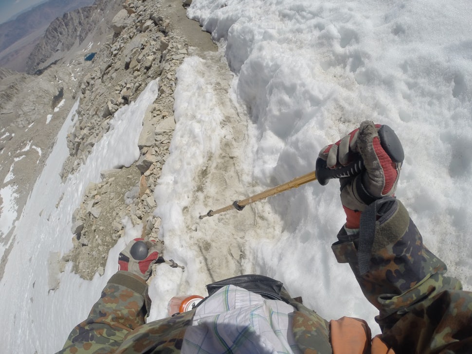
Thefact that I did not have to carry any stove, cooking equipment orfuel was a major benefit to me. The other equipment that I carriedwas a backpack, bedroll, pad, one change of clothes, three smallcameras, and a Tyvek ground cloth or tent depending on the weatherand wind. Not until I got to Mount Whitney did I buy my ice ax andMICROspikes which I bought down in Lone Pine at 3,740 feet.
MICROspikesare what is required at this time of year as opposed to genuinecrampons which are required in the deep crusty winter snow or heavyice which would form on the higher colder trails at night.. During mylast climb day I saw four guys with true 3-inch spike crampons try toclimb the last shoot, ie. snowy valley not a trail in the snow. Farto the right of our 99 switch backs, halfway up they tried a shortcutwhere no path existed. Just too deep and sloppy. They had to turnleft, come over to our trail and then came up the path we werehiking. Too bad, that was a gutsy attempt.
TheRanger in Lone Pinehighly recommended I buy both and as I got on the mountain I wasnaturally confused by many who claimed I would not need an ice ax orMICROspikes as “there is no snow up there” Where they had been isanyone's guess as it sure looked and felt like snow to me. Perhapsthey were born on Mount Hood or the South Pole?? Perhaps they were“higher” than the snow, if you get my drift, pun intended.
Now,a very late footnote to my experience with a different Rangerwho also had served at the Mt. Whitney District in Lone Pine, CA. InOctober 2016 four months after my return home, I was deployed by theRed Cross as a volunteer for Disaster Relief in Myrtle Beach, SouthCarolina. Hurricane Mathew had gone through there and wrecked havocon the people and environment. I was there doing one-on-one work withstranded clients who were temporarily being housed and fed inshelters. I was part of a team who were trying to find escape plansfor those who might have needs filled by agencies in the region.
There I met another ARC volunteer named Kay Hatch-Karstaedt, who identified herself as the former District Ranger for the Mt Whitney Ranger District, Inyo National Forest in the early 1990’s. Kay reflected back on her Forest Service experience as “being paid well to live and work in a beautiful part of the country where others saved to go on vacation”. She said: “My experience in the Eastern Sierras was definitely a highlight in an already rewarding Federal career. I think part of the uniqueness of this experience was the variety of people I worked with – from tourists who wanted to climb Mt Whitney unprepared, to ranchers and miners who were so passionate about protecting their environment. In addition to my co-workers (including my husband) it was an honor to live among and work with a group of dedicated people committed to protecting a very fragile environment for future generations.”
Anessential piece of equipment is a Permit. Not only for Mt. Whitneybut to hike the PCT. Lots of rules and regs to follow and althoughsome are not intuitively obvious to the more casual observer they area way to help us all. The Mexican Border is called Mile Marker Zero.Most start there and May first has always been the first official daywe could start. Over the years the increasing popularity has causedcongestion that no one likes. Lots of toilet paper sticking out fromunder rocks and a wave of humanity destroying small camp areas hadprompted the officials in 2014 to improve the system. It used to bethat 200 people were allowed to start May 1. Now you put in an onlinerequest to start on any one of several days two weeks on either sideof May 1. First come first served, and if your first requested dateis not available then your second request is looked at and approvedif that day's limit is still unfilled. Now 45 people daily are givenpermits of starting there and the crowd is spread out nicely. Thisplace is slang termed “Campo” for “Camp Zero” because we areall in too much of a rush to get started that we do not like to takeall the time necessary to pronounce “campzeeeeroooo” hahah. Butin all seriousness that border terminal is highly policed and permitschecked.
However,if you are not starting there they have another hoop for you to jumpthrough and for good reasons too, “Believe It or Not”. If you hadto apply for a new permit every time you passed through Private,County, State, Wilderness, Federal, Bureau of Lands Management,National Forest, etc. properties, you would need a wagon train tocarry the lawyers to fill out your papers. So, a new system is inplace to help you there, just in case you are one of those who likesto follow rules and not make a new friend in overnight jails:
Applyfor a Long-distance permit. If you promise to be doing more that 500miles on the PCT you will be issued one in the mail before you leave.This request costs little but if you had to stop at each invisibleborder of these places you would be way too befuddled. As I hadindicated earlier I actually forgot to pack mine when I started thetrail at Agua Dulce and it was the first thing I packed when Irestarted. Have I made you paranoid yet?
Threeitems that I did not use but were cheap insurance were my winterparka, ski goggles and ski pants. One night I just shivered for anhour rather than get up and put them on. I also had a small first aidkit, and foot powder.
Chapter6:
PhysicalPreparation
Inaddition to the food & equipment preparation I also worked hardat physical training so that when I got to the mountains I'd at leastbe in fair to good shape. I recall learning long ago that as a manages he loses hair, teeth, skin tension, eyesight, bone mass, jointmobility, memory and taste, but the one thing you can build until youare until 100 is muscle. In February of 2016 I weighed 188 pounds. Itried to get down to 160 but achieved 170 instead. I lost 3 morepounds on the trip getting me down to 167 at my return.
Myregimen from February to the end of May was to hike in Ft. Wayne at aginormus altitude of 714 feet ... hahaha. I hiked the parks, woods,cemeteries and on the sidewalks. I tried to go out three, four andsometimes five days week before the trip and accumulated 75 miles ofhiking which consumed approximately 60 hours. How often have youmowed the grass with a push mower and a back pack?
Thelast week before I left I was up to a 47 pound pack. Without a packfor obvious reason, another exercise that I employed was to godowntown to the PNC Bank and climb the stairs to the top floor andback down several times. This worked different muscles and was foundto be a big help by the time I got to California. (real mountainclimbers train by harnessing a weighted car tire to their belt andleaning forward to skid it along the concrete road for a good legmuscle development and they do this at altitude) Wheeew ... I'm tiredjust writing this now …
Chapter7:
Leanon Friends
UnitedStates Navy second class quartermaster Robert Eugene Johnson hadtaught me everything I know about ship navigation. Now it was hisvoluntary unpaid billet to get me booking on an acceptable passagefrom a pre-planned trailhead start that would've been unsuccessful atbest. “Bugs” Johnny said, “I got some bad news and some goodnews.” “Oh great, just give me the good news”. Johnny said, “Igot a plan B. Right now you're trail is on fire.” I said, “That'sthe good news? Or did you say my tail is on fire?” At least I couldcut my tail off.
TheSouthern California drought is the result of climate change andcontinental drift which has been going on for 3.9 billion years. Irefuse to believe we caused continental drift or the other, but I maybe wrong. Fire, flood, mud, and drought are the current seasons inSouthern California. The Pacific Crest Trail had been closed today bythe “regulators” who we the people have allowed to exist. I amhappy they do but sometimes question why they do what they do. If itis in the best interests of all I am inclined to give them thebenefit of the doubt. Their only problem is that if they areoverruled by a government agency they have a checkered bureaucratichistory as their legacy to live down. My emotions said “go”, mybrain said “listen to knowledgeable authorities”. So I did.
Myfirst nine-day leg between resupply roads had been blocked by forestfires and although the trailhead at the Tehachapi Pass was open, theresupply point for my next food cache was officially closed to allhikers north bound. Walker Pass was 90 trail miles away and currentlyno one was allowed to proceed north of that. And thus no new hikerswould be allowed to enter at Tehachapi. Rumors abounded that KennedyMeadows South was being evacuated. “That would be unprecedented”,said one Brew-master hiker from Milwaukee. I found out later thatweek that this also was not true.
PlanB, should you accept it Johnny suggested, was to start even furthersouth at Aqua Dulce, California.Interesting to me that the Spanish translation for that is“freshwater”, literally “sweet-water”. Later I wouldtranslate it as “Whatwater?”About Agua Dulce per Wikipedia:
VasquezRocks has been long used as a popular filming location by theHollywood movie industry, most notably The Flintstones movie, MelBrooks' Blazing Saddles, and the Star Trek episode "Arena."The 1971 movie Duel filmed extensively in the area, as was thewestern film More Dead Than Alive. Other films shot in the area areRat Race, 127 Hours, Bill and Ted's Bogus Journey and The ImmaculateConception of Little Dizzle. The History channel shoots the popularreality TV show "Top Shot" in the hills and canyons on thenorth side of the valley. The Agua Dulce area has also played host tomusic video shoots, including those for the Bloodhound Gang's "YourOnly Friends Are Make-Believe" and Weird Al Yankovic's "ILove Rocky Road", and various Nike commercials. Vasquez Rocksgot its name from the famous bandit Tiburcio Vásquez who used themas a hideout.
Itsounded sweet to me and so we headed there, about 50 miles away asthe parched crow flies, to sort out hiking equipment and get thisbaby under way. Coming directly from the train station I unloaded allof my equipment from Bob's truck. It took about an hour or so to sortout what I needed from what I had. Every thing that I did not need Iput back in the truck so that Bob could store it at his house in themountains. It took about an hour and although I probably did not needeverything that I packed the adrenaline was flowing and my positiveattitude said take it. I can always throw it away later. While wewere there many fellow of PCT hikers were getting resupplied and wemet a little gal who had started at the Mexican border May 1. Hertrail name was giggles I was obvious why she had that moniker. Sheasked if we could take her to the trail head where I was going tostart but later three hikers convinced her that a day off would be inher best interest. I had been psyched for months and by noon that day“my bags are packed, I'm ready to go” as the song says. ♫ ♪
Boband Jan dropped me on the trail, well not literally, just north oftown at Lime Road (was this a bitter irony, where later I would haveto adapt and adjust to make lime aid from limes? I had at least 50pounds of gear but I was stoked and headed north. Bob took what wasintended to be a before and “phony” after picture; one where Iwas headed uphill and number two where I was “clicking my healssmiling” and running downhill. But here's how it really happened:
Athigh noon there was no shade in 103 degree heat (“but it's dryheat”) Yeah, right, so is an acetylene torch, the surface of thesun, a lit match! I headed uphill dragging my 20 pound travoy behindme. It made a potentially embarrassing drag mark in the dust but Icould explain with a phony limp and a true broken back story ifpressed by some young whippersnapper. The lawyers said no wheels ormechanical device so I fashioned a sled from three Frisbees made ofunobtainium and tied them together with parachute cord. My heavy foodand water bounced along the trail as plastic friction between it andMother Earth relieved my back. My back was broken in a bicycleaccident 15 years ago, the day our first grand child Bailey Spurr wasborn. My C7 vertebrae had healed and my German attitude said “justdo it”.
Upthe hill I climbed looking at my GPS and receiving no signal. Grr.Dead batteries had resulted from an inadvertent “On” bumpprobably from the Amtrak roller coaster ride. An hour later my cellphone had no signal. Getting spooky here ... I had started this trekunder the ConEd high tension power lines that hummed so loudly thatBob and Jan noticed it when they honked for me to come back to thecar to retrieve my Smart Phone which I left in the rush to get thisbaby started.
Nowout from under the electricity my GPS registered my latitude andlongitude. The bad news is that my maps were not written in latitudelongitude degrees but a new and unknown to me scale called UTM. Itwould not be for three days that I could coordinate my high techdevice with my paper maps. Within five hours I was lost. Heart rateup to 140, breathing at an all-time high, O2 level at an unacceptablylow percentage. Brain waves, normally low in my experience comparedto my 1963 High School classmates who were following me on Facebook,were now in the negative numbers. I could not recall where I had lostthe trail. I could not recall where I had lost the trail. Icould not recall where I had lost the trail!!Shocked by this revelation I dropped still and silent.
Thetrail was once 10 feet wide. I looked at my feet to see if there wereany foot prints or rattlers as if I could see either in this brush.And now not even a rabbit path was in sight. Realizing that my lastknown fork in the PCT was nowhere in memory I recalled the old quote,“When you're digging yourself into a deeper hole and don't knowwhich way is up, put down the shovel and stop!” So I did.Scrambling out of my bushwhack situation of plowing over naked bushand brush was really very strenuous work. The land was undulatingrocks and boulders everywhere cactus snagging my close and on severaloccasions trying to bulldoze through the underbrush was impossible. Ihad to backtrack several times and I knew by the map that the milesahead of me were all up hill. Steep hills. I found a clearing in thecactus scrub hiding below the shadow of a California tree and droppedmy gear. Shut the cell phone off. Shut the GPS off. Save batterypower and water, slow the heart rate, slow the breathing, stop andthink. It was getting late fast and I was already into trouble on myvery first day. Yikes!
Backto my memory came a quote that I recalled from one good friend whohad always given me sound advice. Bob Thompson last said to me inpreparation for this trip: “When you get in trouble, sit down andthink.” So I did. I rolled out my Gore-Tex Bivvy sack and unzippedit. Inside was my sleeping bag and blue foam pad. I lay down andfocused on my heart rate. I picked burrs from my socks for at leastan hour to focus my mind on slowing down. I learned this trick bywatching videos of President Reagan chopping wood at his ranch inSimi Valley a few miles away to aid him in stress relief. Heart paceand pressure was up but coming down. I had drunk five of the 6 quartsof water I packed. I was lost. But also hungry, which was a criticalrevaluation for survival. So I mixed up my powders to nourish myblood and refresh my memory of where I went wrong.
“Lost”is a relative term I say a little defensively.I knew my altitude with my Garmin Legend eTrex so the map helped methere a bit. I knew what squiggly line I was on but not whereon the line. I had used this technique in the navy on USS Topeka CLG8to follow the known depths in channels where dangerous shoals werelurking and to keep us out of harms way, not actually me but theNavigation Division teammates used it to plot our position. I couldsee in the setting sun the gleam of the corner post of a rancher'scattle fence northwest of me. I knew where I was but the map did notreadily agree. If I walk west I will find the PCT but not now, notthis late in the day. I needed to reconnoiter how I was going to getmyself out of the mess I was in. Mentally pretty peaceful that nightI picked out stars and planets by name I had learned during Navynavigation aboard ship.
Othersactually knew better than I where I was. SPOT sent out my trueposition and immediately all my FB friends and 9 specials who wereprogrammed on my e-mail list could tell at a glance where I was. HadI thought of this I probably would have tried phoning one of them andasking where I was, but that would not have happened because here inthis valley at 2,900 feet and my destination of Bear Spring at 4,300I had no cell phone capacity. You can see the Blue Circle in theattached map is “Me” and I was the only one I ever cared aboutwho did not know I was only 10 football fields from the PCT.
Dryand cramping. As I sat on my pad I watched a long string of ants movesouth. They were carrying the equivalent of their nursery on theirbacks as well as food, figurative refrigerators and shopping carts.They were moving out across MY land. It occurred to me that if I didnot move my food, it too would be moving south by morning. So Istuffed all my/their ant food in a stuff sack and hung it as high aspossible on a dead Yucca plant nearby.
Nightbrought the most unusual leg cramps I have ever experienced.Hips/groin/crotch outer, inner, and back leg muscles twitched againsteach other. Gluteus maximus, gluteus medius, gluteus miserable-us.Dang!! Stretch one to relieve it and its opposite complained, tillyou tried to satisfy it and its neighbor complained, till you triedto relieve it, etc., etc., etc.
Allnight and into the next day it persisted in lieu of the fact that Iwas drinking copious water and sucking salt pills. Would this neverstop? Oh how a good vibrating train seat massage would feel rightnow. Conductor, come back! Hippie with her beer, come back! I missyou-- 'now'!
Inmy Bivvy sack on my back I watched the bright stars in the clearCalifornia desert night twinkle as my leg cramps kept me awake morethan asleep. In the morning the sun came too early for my tiredmuscles. Heat climbed sooner than I rose and when I did I knew I hadstayed down too long. Up I got and looked back from where I came butstill had not been able to recall where I left the trail. Studyingthe map I determined only one thing for sure that west was away fromthe sun and back to town so I tried for half an hour to figure wherethe trail was by traversing up hill and down hill north and south.Finding no trail I knew it must have turned way back west so Ibushwhacked through the dead brush and thought hopefully I was on thetrail several times as I saw paths of some sort. I guess they musthave been some errant horse or wild game tracks. I finally reachedthe point on my map where it zigzagged across a dry ditch and headednorth west. The jog where the word SCENIC ends, that is where I foundthe trail about 1,000 yards from my night camp. I had to spend abouta full hour to find this intersection. I got my video camera out andtraced it so when I got home I could prove to myself how difficultthis left turn had been to notice.
Ileft my pack at the intersection and walked it a bit just to prove tomyself it was really there after all. It was a left down through ashort 10 foot wide valley, cut left up a rise and off to a sharpright. The hike back to my trail head was emotionally difficult as Ithought of all the work I had put into planning this trip. I metthree men coming west from behind me as they had hiked out from AguaDulce earlier in the day when the sun was down and air was cooler. Bythe time I got close enough to see civilization I was already prettyhot and out of water. Hiking down through a junk yard I found a ranchwhere a stable hand was kind enough to give me directions for theabsolutely shortest route to town. Even that short route was drainingas I was hot and parched and a bit pissed off. No piss in my butstill...
Youknow, here is a good place to mention a personality trait I havealways observed in those able to cope with difficulty in thewilderness. I imagine it was also a trait of the cave men that helpedthem survive. Humor. That is what has to bubble up when the gettinggets really tough. If with others, smile and make light of thesituation. Think what if!! not what if?? When alone think of howsilly you were to get yourself in this pickle and how wonderful itwill be to tell stories of how the heck you got out alive. I was nowhere near not getting out alive but it occurred to me several timeson this trip to find the humor in the glitches. Frankly it was duringthese times that I got the idea of writing this book. You stillhaving fun?? No? Well cheer up, it might get worse and this mightlook like fun later
Backon Lime Road I stuck out my thumb to hitch a ride and got passed upby several rich looking cars. Then a raggedy old Chevy pick up drivenby Hector stopped and he gave me a mile ride back into town. Herelayed a story of when he hitched a ride and gave the driver $50 forhis trouble but that driver turned it down saying he was performing apay back for an earlier similar situation. I think Hector was givingme an out because he knew I was appreciative and would have offeredmoney as well. He even gave me a cold soda-pop.
Nowback at the same parking lot where I had done my final packing Ifinally was in range of a cell phone tower. I needed to call Bob andask that he come back as the trip is now totally unraveled and up formajor changes. I ate a large pizza at Big Mouth Pizza and sucked afew beers for relief.
Sohere I was, chagrined at the end of my first day still in Agua Dulce.I called Bob and he came back to get me. DangI hated that!
Chapter8:
DetoursTaken
WhenBob arrived at Agua Dulce for the second time today I packed my stuffback in his pick up and off we went to his mountain house in CampNelson. I had been there once before in 2005 after retiring thatAugust. The road up to his house has a gillion curves in it and thetown at the bottom is Porterville. It is refereed to as Ordervillebecause whenever they shop for any item not in a grocery store theyhave to put it on Order.
Youought to look it up on Google Earth and count actually how many zigsthere are. There are an equal amount of zags to be sure. Jan drovethat to work every day. Yikes! It is a pretty drive up and I wasexhausted and a little light headed from all the action of today andlack of sleep last night on the train.
Earliertoday they picked me up at the Amtrak train station so that I couldget started hiking the PCT. As we paid attention to the Californiaforest fires I thoroughly realized I wasn't in Indiana anymore.Shockingly I learned but did not want to face the conflict that I hadnow. Too hot in Tehachapi decision was behind us. Now either changethe start place again, or adapt and adjust and change this wholemountain-thing plan radically. I hoped that this calamitous startfrom Agua Dulce might be another door opening. I hoped positively asmom had taught me.
So,not knowing whether my PCT days were over or not I cooled my heals atBob's house in the Sequoia National Forest to acclimate to his 4,400foot elevation and think things over. In retrospect he and she bothregretted not advising me at the start during spring planning to getused to the altitude for least a day, but I retorted then that Iwould have rejected that advice and put up a fuss saying “I amready, willing and able”. Wiser today I would put a “not” inthere somewhere...
AsI found on line that (thanks again wiki) 'Although the southernsection of the Giant Sequoia National Monument contains 22 sequoiagroves, only six are easily reached, being within 2 miles of a pavedroad; the remainder need longer trips, on trails or forest tracks.Second in popularity to the main visitor area at Long Meadow Grove isCamp Nelson, a dispersed woodland community 32 miles east ofPorterville along CA 190, as from here three groves may be visited byshort trails - Belknap Camp, McIntyre and Wheel Meadow, of which thelatter two are most scenic, spread out along the deep valley of theSouth Fork of the Middle Fork of the Tule River. The 3.6 mile CampNelson Trail passes right through both groves, starting in the westat the end of a narrow road from Belknap Campground, and in the eastfrom a parking area beside CA 190, 1,650 feet higher. For hikers, thetrip is one way but the path is also popular with mountain bikers,who can make a ten mile loop using a cut-off trail and a section ofthe highway.' While there I saw several.
Snowpersists in the upper reaches of the Tule River valley until April,but the trail is usually hike-able from mid March. The lower grove(McIntyre) is more visited since it lies closer to the road; thehigher section of the trail is much less used, yet still easy tofollow, and encounters somewhat larger and more extensive sequoias.
Annually,Camp Nelson hosts the summer Mountain Festival in the Camp NelsonMeadow, which was established through the John M. Nelson conservancy.Apart from the annual festival, visitors come to Camp Nelson to seethe grove of sequoias near Belknap campground. I visited both. Asmall tungsten mine operated in the area until the 1950s but I didnot realize it at the time or might have hiked to there.
Bobhas winter visits from bears who used to raid his bird seed on theback porch. I've seen several hidden camera still shots of hisfriends. Also, mountain lions in this area do prey on anythingincluding pets so the experienced residents bring them in at night. Isaw lots of deer in his back yard but no bears or lions thankfully.Lots of enjoyment was had nightly as they thought no one was watchingtheir natural antics Bob gets to do that every day.
Thereis a small town-owned RV and tent camp a short distance from Bob'shouse where I went for four days and three nights to practice mynavigation skills with a reprogrammed GPS. My paper maps that did notuse the latitude and longitude scale which I had become accustomed toin the Navy as a navigator. I read some pamphlets about the area anddecided to hike two trails both of which were in mountainous areas sothat I could keep up my muscle mass while acclimating to the thinair.
Thefirst day I hiked the Nelson Trail and got to within a mile of it'sintersection with Highway 109. Not only did I practice with the GPSbut used my hammock so that I could familiarize myself with itscomfortable sleeping positions. I bought an ENO Double Deluxe Hammockand could almost sleep stretched out sideways. The next day I didBear Trail which was a very steep mountainous grade incline and inboth instances did 5 or 6 miles each day. I marveled at Giant Sequoiatrees and spoke with foresters cutting down dead sugar pines andspruce due to the drought and resulting insect infestations whichkilled many trees. Forest fires just love dead sappy pine woodstanding tall waiting for a spark and a breeze. In September I hadcalled Bob who told me they had three fires going close by but he didnot seem worried. I'd be there with water trying to stop it fromcoming closer to my house. I am not used to what they have had to getused to.
Sobefore I could go anywhere with my eTrex GPS I had to to reprogram itin UTM coordinates versus the latitude and longitude because the mapsof the Pacific Crest Trail are in UTM coordinates. UTM stands forUniversal Transverse Mercator. Bob and I Goggled the internet andfigured out how to adapt to the map by editing to this new system onmy GPS. We had learned a lot on the USS Topeka in the Navy in my1968-1969 time frame but we did not learn all we needed to know. YouCAN learn Anything if you are 'an old dog with a positive attitude'.
Ihiked to Coy Flat and Belknap along the Tule River during those days.Wondered how large the trout therein would be and how tasty a friedskillet full would smell. At night I used my home made Tyvek andtrekking poles frame tent. Tyvek is the material that new houseconstruction uses as a breathable element which I got online. Moreinfo at Tyvekbythefoot.com. It is sold 9 feet wide and I got 5 feetof it at $2.50 per foot. At home I fashioned it with grommets so Icould stake it down at the corners and prop it up in the center byusing the tips of my trekking poles through the grommets and placedthe handles on the ground. A tight fit but I am happily notclaustrophobic. I used it later on Mt. Whitney as a sun awning.
WhileI was at the camp near Bob's house I fed the ducks that wereaccustomed to calling that place their home. Lucy was the Queen duckand although she did not eat out of my hand there was plenty of foodprovided by the camp owner and several Mallard ducks in the pondcreating a very tranquil camp scene. My routine there was to wake atfive and be on the trail by 9 AM. This area of National Forestactually has larger Sequoia trees than the general vacationing publicis exposed to in the Sequoia National Park. Each night I had acampfire and read the book “The Other Side of the Mountain” byAlton Pryor which Bob had loaned me.http://www.barnesandnoble.com/...Written in a rather amateur style, I began to ponder a style I mightuse writing my own book for the first time. Bob had also asked thatif I write down anything about my trip he would appreciate readingit, so here you go Johnny, just a few short scribbles ...
Mr.Pryor described the settlements near Lone Pine and Bishop Californiain the Owen Valley. Back in the 1800's the lake and those waterresources soon became valuable for the city of Los Angeles. Mr.Mulholland for whom Mulholland Drive was named was an engineer whorealized that if he bought up all that land he could divert the waterin pipes and canals to supply drinking water for the residents of LosAngeles. He did it so successfully that now that valley is bone dry.Ouch! Now all I could see were backhoes and bulldozers on the lakebottom. Interestingly Death Valley's 287 feet below seal level isonly 76 miles SE of our highest peak Mt. Whitney at 14,505. Annualfoot races take their toll on fools with ego enough to try, not methanks. The hot desert conditions wear out several pairs of shoes andthey put tin foil in the soles to help keep the feet cooler.
Workingwith my smart phone in UTM coordinates I soon realized that the PCTwas only 27 miles east of Camp Nelson and I was anxious to getthere. Mile Marker 707 near Kennedy Meadows was the closest point ofapproach and was tantalizingly near as I stalled and detoured,waiting out the unseasonably high California air temperatures andforest fires in the area.
Bythe way, when I was planning my PCT hike agenda back in Ft. Wayne Ihad bought nuts and seeds because they are highly nutritious andpacked with protein and oil for long-burning stamina. Dried meat ofcourse is always a staple for hikers and I had dried it and Velveetacheese at home using my son David's dehydrator. Much lighter than theDinty Moore Stew he and I had heated many years earlier in a swamparea west of Fort Wayne while watching sand hill cranes in the JasperPulaski County Game Preserve. These were the lightweight foods that Inow practiced digesting during hikes near Bob's mountain house inhopes of using some day soon on the Pacific Crest Trail.
Also,during that wait and see time that I was at Bob's I helped him plantfour quaking aspen's near his driveway. Also, Bob had a bar tableunder a heater device that needed refinishing so we attacked thatproject together. All this was helpful to relaxingly think of my nextplans as well as get my blood used to California's mountains.
Aftermy camping out in the Sequoia Forrest for four days, Bob and Janoffered “lets all three go visit the Hearst Castle.” Fires stillkept me away from my plan so it was time to alter everything andforget our troubles. On June 8th, 9th and 10###sup/sup###we drove the camper and tuck first to Morro Bay which is a fishingvillage on the Pacific coast directly west of the San Joaquin Valley.It is near San Luis Obispo. Koohl placefer sure fer sure dude.
PerWiki the history is here: The prehistory of Morro Bayrelatesto Chumash settlement, particularly near the mouth of Morrow Creek Atleast as early as thousands of years before present, there was anextensive settlement along the banks and terraces above Morro Creek.The first European land exploration of Alta California the SpanishPortola expedition , came down Los Osos Valley and camped neartoday's Morro Bay in 1769. Franciscan missionary and expeditionmember Juan Crespi noted in his diary that "we saw a great rockin the form of a round morro".Morro Rock latergave its name to the town. The descriptive term morro is common tothe Spanish, Portuguese and Italian languages, and the word is partof many place names where there is a distinctive and prominent rockformation. Note that the similar Spanish descriptive word "moro"indicates a bluish color rather than a shape.
CorcoranState Prison is on the way where we contemplated stopping in to chatwith Charlie Manson, Juan Corona, Sirhan Sirhan and Phil Spector butreports of a sign at the front door “Welcome to Hell” deterredus. Besides we did not want to impede their fast rehabilitation intosociety.
Whilewe were at Morro Bay they camped in their trailer and I slept in thebed of the pickup truck at an RV park on the beach. It was a verywindy four days and not the most pleasant weather conditions thatmost Californians are used to. Walked the dog to the beach andgenerally just relaxed and had a good time. We ate extremelydelicious seafood which is always fresh at the coast and properlyprepared by competent chefs who present them beautifully, being muchbetter at this than I have found in Fort Wayne. One day I rented akayak and paddled out to an island and around a collection of furseals and among otters. Also that day I rented a bicycle for twohours and pedaled north up the coast to see what the city and thehouses looked like.
Everyday when I was in California I would push the button on my FINDMESPOTGPS device, checking in to say I'm okay so that family and friendscould be emailed a link to my location and see daily postings onFacebook which showed FB Friends that I was safe and sound. That wasthe extent of my ability to interact with friends because as I havepreviously indicated cell phone reception in the Sierras is minimalat best. Also, because computers are not what grandpa had, I becameaverse to using anything more complex than a phone to talk with theoutside world. Grandpa probably wrote letters and I would give $1,000to read one now. I wish he had been able to document what was on hismind back then out west in Colorado in the silver mine business. Butthat's OK Grandpa, staying alive and not getting robbed was moreimportant. I like your priorities.
Becausethe weather in Morro Bay was so cold and windy I bought a pair ofblue jeans and had somehow lost my sunglasses so we did someshopping. I took a lot of pictures of the surf and sea birds becausethe wind was at 40 mph and the birds were having as tough of a timewith the weather as I was. During this section of my trip I decidedto send Kathy an anniversary present consisting of a fruit flowerarrangement.
Whilewe were in Morro Bay we finalized plans to go to the Hearst Castle.The place is well preserved and a very nice tour package was offeredto us. Several hours were spent exploring the grounds. You get aticket for $25 and are allowed to go on one of several differentexcursions. We took the Grand Rooms Tour but there are five others:Upstairs Suites, Cottages & Kitchens, Evening Accessible,Designed Grand Rooms, and Accessible Evening tours.
Thebus ride up the mountain to the castle was interesting as they hadherds of cattle interspersed with zebra and mountain goats but nolonger giraffes and exotic animals which he could afford before theygave the property to the state of California. We saw many statues andSpanish architecture of the building but not every room. All thesculptures were imported from Europe. There are two tennis courtsforming the roof of an amazingly beautiful swimming pool.
Allduring the time at the Hearst Castle and the time spent at Morro BayI was making mental notes of what I wanted to pack when I got back tothe Pacific Crest Trail. However, my plans were now morphing awayfrom the very desolate and dry 200 miles from Tehachapi Pass, WalkerPass and on north through Kennedy Meadows ending up at HorseshoeMeadows several miles south of Mount Whitney. The focus of my mind atthis point was to skip those sections which would've consumed 20smoke and fire threatened days and nights and to instead plan onleaving from Yosemite Park long hauling it up through resupplies atSonora Pass and finally past Echo Lake and finishing this 200 milesby wrapping it up at Donner Pass. Grrrrr! I wanted to do it all but Smoky the Bear said “NO”.
Youask “Why did I hear “No”? Smart question, thanks for asking.Would I ever get to go? You surely understand that by now but I didnot at the time. Grr again. I've always wanted to fully and clearlyanswer this question: "Why did I not hike the PCT as I hadplanned?"
Firstof all were the actual trail closings. If closed by CAL FIRE (Stateagency responsible for protecting natural resources from fire on landdesignated by the State Board of Forestry as State ResponsibilityArea) I faced a $2,400 fine if I set foot on the trail before it wasreopened. Second were the food drop sites. If Bob had to drive uproad X from his home to the west and meet me at the Trailintersection, how was he going to do that on time for me to eat anddrink if his only road was closed? If he had to come in from the easthe would have to detour over hundreds of miles to get there and hopethe intersection was still open. If the smoke blows onto my sectionof the trail I suffer and air is scarce enough up there withoutpoisonous gasses. I had a dust mask with me but that was only a roughash filter. Additionally we need to respect the fire fighters who areburning back-fires and plane bombing with suppressant as they do notdeserve to be hampered with dumb humans needing evacuation. They arebusy enough saving life, property and forest vegetation. Animals alsogot scared and try to find the small remaining areas to eat scarcefood and water sources.
Thesecond section was less likely to be afire and would take me 200miles or 20 days, being much more reasonable in the altitude and theangle of attack. An inviting feature of doing the north half startingin Yosemite is that the general topography is downhill rather thanuphill. That section starts at about 10,500 feet as opposed to the3,771 foot elevation at Tehachapi and is wooded, much cooler and, asI say, drops in elevation rather than rising thus increasing oxygen.However, as we paid attention to the news there was still significantthreat of forest fires breaking out thus maybe canceling the entireplan again. The record will show that while I was there, there werefive significant if not major forest fires between San Bernadino tothe south and Lake Isabella which were in the northern sections of myplanned PCT hike. Not knowing that at the time I made a list ofessentials so that I would be much more reasonably downsized inweight and bulk than I had been when I left Sweet Water a weekbefore.
Californiafires all get a name based on the point of origin. Trail head fire,Marina fire, Lone Pine Fire, Lake Isabella fire and Erskind fire allaffected my plans. We drove past Echo Lake and Silver Lake on the waynorth and saw the red fire suppressant where the Boeing 727 bombershad left their mark on the unburnt roads. Lee Vining had theadvantage of a lake at their city limits and the fires were doused bythe time we got there. Their town was saved from total destruction bythat pink slurry this year. I suspect that lake had served the samepurpose in prior years.
Chapter9:
TreadLightly
Iforgot to tell you one activity I had done back at Bob's before wewent to the coast. Hey, you try editing a book. Hahah
Inorder to fashion a lightweight pack to hike up Mount Whitney and notcrash as I had on the PCT, I redesigned what I had brought from home.A rigid internal frame pack Bob Palmer and I had used for 50 miles onthe Appalachian Trail in June of 1995, when I was fatter and younger,I now decided to modify by removing the shoulder harness. I dreamedup a design in my sleep one night and slightly scared Jan as Ihypnotically bulldozed past her at home and went to the back porchand cut a template of its outline from cardboard. Sorry Jan, I am amystery sometimes when inventing.
Johnnyhad an eighth-inch thick sheet of fiberglass and I hacked and whackedit into what I describe as a 'papoose board”. Indian mothers usedto carry their papoose on their back. The baby was held close andlashed to a flat board so that mom could hike or work unencumbered bythe presence of the baby. I changed that concept into carrying nylonstuff sacks containing my gear and strapping them to my new papooseboard, then to the shoulder harness from my pack. That redesign of mybackpack dropped the weight 6 pounds which was highly significant anda very successful move.
Chapter10:
Attackthis Mountain Lion Trail from Her Flank?? I asked metaphorically
Duringthe days after my scorching trail out of Agua Dulce, hiking Sequoiaand chilling at the coast, my mind wandered in search for a planbeyond these Mother Nature limits. Did she see me coming then bristleand heat up just to scare me off?
Todaywas near the longest lighted day of the year when the sun came up asthe moon went down; when the moon came up as the sun went down.8:30pm and 5:30am were similar now. Base camp on Mount Whitney is at8,000 feet. Her summit is 14,505 feet. She is an unmovable animalright in the middle of my trail. Whitney Trail, John Muir Trail andPacific Crest Trail all merge up there. But how could I make it upthere if I can't make it down here in southern California's desert at2,900?
Idreamed out of the box. I always have started at a trail head but Icould change that slightly. Maybe a lateral? Come into a trail from aside intersection? She's still out prowling at night so I could chilldaily and hike nightly as many do; only dimmed in a long twilight.But I'd miss the vistas. Might not see bears and rattlers ... ShouldI hike a snowy cold treeless mountain to sneak up on this wild andfiery PacificCatTrail from her right flank? Foggy dreams of Plan Cwere clearing. Snow and granite seemed better than cactus and sand.
I'venow learned why I must change tack. But How? This is difficult at myage and background. Be logical, plan, do what my body allows. Evenfor the young there is no air up there. My feet hurt and musclesache. I want to quit. One hundred and one excuses. Lots of irrationaland rational fears.
Whitney'ssummit is 2.7 miles above the surface of the ocean. Air planes mustcarry oxygen above 10,000 feet. The mixture of oxygen in theatmosphere is always 20.7 %.The other constituents do you no good andsome in large quantities actually do you harm. Oxygen is still thesame ratio at all altitudes but the pressure changes the amountavailable to your blood. Fewer oxygen molecules per cubic feet aroundyou. Fewer oxygen molecules per lung full.
Asyou climb higher the reduced pressure is the cause of this countreduction (not the percentage) of oxygen so what is labeled an“equivalent % Oxygen' number is used to represent the loss. At sealevel the equivalent % is 20.7, but at the top of Whitney theequivalent is down to only 12.7 %. Essentially that gives your lungs42% less energy to be supplied to your muscles. Not only muscles butdigestive system, brain, vision, emotional control, liver forconverting protein to energy. EVERYTHING slows.
42%of 71 years old is 30 years. Does this make my lungs like that of a101 year old? My kidneys, pancreas, spleen? Yikes!
Happilymom and dad always taught me to think positive. Some people alwayssay: “Yeah but, what if? What if you buy a BB gun and shoot youreye out? Some say “What if I dig here? I might break my shovel.”I think: “What if I dig here? I might find gold!”
“Gobeyond your limits” I kept hearing. Who was saying that? Grand Pa? Mother Nature? God?
Chapter11:
Fateon My Side
Didmy guardian angel start dreaming of this mountain climb backin Agua Dulce? I hung my downsized pack on the scales hook at WhitneyPortal trailhead two weeks later. Were my lucky stars with me! Was itGrandpa Nix looking over me from heaven? All the literature that Ihad read said that only 100 permits would be issued for one-day hikesto the top of Mount Whitney. Somehow a four-day permit had beenissued to me by a Park Ranger on this Monday after Father's Day. “Noway, that can't be, they just don't do it, I got a one-day permit for$15, you got four for free?” many hikers said.
Thesecond miracle was that even though the Whitney Portal familycampground was full I was issued my six day camping permit. Justwalked in and it was sold with no questions asked... Hmm … Everyhiker and biker I told this story to was shocked. But that's the wayit was. Was it Jimmy Tagtmeyer our friend from grade school sneakingfavors to me from God?
Ipopped a chill pill to get a good rest that night. Packed up in themorning I hitched a ride to the scales at the trail head. Fortypounds! Yippee. My wants and my needs had been separated back at CampNelson where I had developed plan C the week before. Downsize. Downweight. Down needs. Drop wants. Carry essentials. Down weights more.That was my mantra. That was my MUST. Like when in high schoolwrestling we starved to make weight so I did not have to wrestlethose heavier weights.
IfI was going to scale Mount Whitney, the highest mountain in the 48contiguous states, I would have to get lean and mean. My physicalbody had been conditioned in Fort Wayne at an altitude of 714 feetabove sea level by 60 hours of hiking with a 32 pound pack on my backand accumulating 70 miles on relatively flat terrain. Coach BobPalmer had been my loyal trainer all spring and he drove me like arented mule. He pulled me like an oriental saw to sculpt my musclesand reduce my fat, he beat me like a cold chisel until I looked likea Spartan Warrior ... Yeah right
Istill had a belly and was no spring chicken. I had lost 12 pounds andwould lose 3 more before weighing my spent carcass on the home scalesagain. BUT: Now I had a goal of 2,000 feet elevation climb per dayand an overall distance estimated at 10.4 miles. Best news was Icould not get lost on this well worn Whitney Trail. No topo or GPS tocarry here, just muscle and water were my essentials now.
Thetrail conditions and stream crossings, the zigzags and the packweight are just small factors now compared to the lack of oxygenmolecules available to my lungs and bloodstream- most urgently myheart muscles and brain tissue. But “I could do it” I told mysoul. Did my soul hear me? Did she believe me? Did she believe in me?Had she deceived me or had I deceived-myself-that-I-deceived-her?Sound crazy? That's how fuzzy I soon became in Whitney's steeptreeless reaches.
Upat 4:44 was usually my mantra. Last year, June of 2015 found me onthe North Slope of the Grand Canyon. Even then I was up at 4:44 AM.In the parking lot with 20 other cars,taking deep high altitudebreaths I was one of two parties getting awake enough to start. Thenight before I had selected what I must have in my 8.5 poundbackpack. Going down was easy and it was 70°. When I start high thebreathing is easy and as I descend pants get more rapid but thickerair so all equals out. I love the smell of mule piss and the feelingof their droppings beneath my boots as I hiked energetically towardthe river one mile below from 7,500 feet to 2,422.
Backcountry hikers often speak in altitude measurements rather than trailhike miles. The Grand Canyon's North Kaibab Trail is a 17-milewell-established path down to the Colorado River which for years manyhikers have enjoyed. It is well trodden and fairly stone less. It'scool at the top and hot at the bottom because that's the way MotherNature dictates. 113° for several hours was waiting for me. I hadsome sense of it but my body would soon be trying to adapt and adjustto what I was putting it through. “Could it cope?”, I askedmyself many times that day. I tried to listen even though my earswere popping from the increased pressure being river valley bound.
Hikingdown the G.C. switchbacks last year was exhilarating and would teachme some of what I needed to know this year on Mount Whitney. Theprevious night of my decent to the Colorado river a G.C. Ranger hadsaid to “eat when you're tired and take a two-hour nap. When thenovice hikes he eats on the trail and the food rots in his gut. Theexperienced slams down water, oil, protein and salt. Hike in themorning and evening shade and wear wet cotton. Bikers' polypropylenewicks away vital water and cooling is actually reduced.” So I did.After several hours of peaceful hiking down from the crowded NorthRim the oxygen was going up but so was the heat. A stream runs from anatural spring coming into the canyon off of the North Rim. That wascooling and quenching.
TheNorth Rim is 1,000 feet higher in elevation than the South Rim. Itterminates a long gentle slope to the south because again that's theway Mother Nature wants it. The Colorado Uplift has been raising thisland for millennia and a natural erosion on the North slope hasallowed that rim to recede more gently and horizontally North becauseits rain and snow has erode that side back toward the north. Thatedge of mother nature's escarpment has now tumbled down into theriver. Contrarily, the South Rim edge is much more vertical down tothe river because water falling there flows southerly towardFlagstaff and does not erode rock into the Colorado.
MountWhitney's base camp and the Grand Canyon's crest are both below thetree line. I've learned that the tree line has little to do with thecold or the snow or the ice or the wind but the oxygen in the air.Although trees breathe oxygen out they need some to survive. The treeline on Whitney at about 12,000 feet tells the trees “no way J.”
SoonI would hang my pack on the scale at Whitney Portal and be delightedto see it register only 40 pounds with water. I flash back to my packon the hook at the North Rim where I was elated it first read 9pounds. Going down last summer and up this summer was different. Ikept saying, “I can do this!! I have all the time in the world.Slow down Jimmy”. Now up on my back, waist strap secured snugly totake 90% of the load, I readjusted my shoulder harness to take up theother 10%.
Shoulderharnesses are for horizontal motion fore, aft & lateral. Thehuman hip and the pack mule's strong back bones are designed to takethe majority of the vertical load. I hang my Nalgene bottle in aBeaner on my right shoulder strap, pull on the Velcro cinch of mybaseball gloves pushing my hand up through my trekking pole's loops.I look up. I smile. ''I walk therefore I am'' quote comes to mind.What the hell am I doing here? Who the heck thought of this? Grandpa,you there??? You scoundrel, you got me hooked but I love it, and you.
.
Chapter12:
GettingReady to be Ready
June19 was Father's Day and June 20 I had arrived at the visitor centerin Lone Pine, California on Highway 395 just north of the dry OwensLake bed after a long trip with Bob in his pickup truck while Janstayed at home. Now, thinking plan C+ I had accepted the partialdefeat of not doing the south half of the PCT but to hike up to thetop of Mount McKinley who's summit is 14,505 which is higher thanPikesPeak, located in Cascade, Colorado, which is 14,115 feet tall.PP is the 31st-highest mountain in Colorado, but it is the mostfamous, with more than 500,000 people reaching the summit every yearaccording to wiki.
Wikidescribes Whitney here: The summit of Whitney is on the Sierra Crestand the Great Basin Divide. It lies near many of the highest peaks ofthe Sierra Nevada. The peak rises dramatically above the OwensValley, sitting 10,778 feet (3,285 m) or just over two miles abovethe town of Lone Pine 15 miles to the east, in the Owens Valley. Itrises more gradually on the west side, lying only about 3,000 feet(910 m) above the John Muir Trail at Guitar Lake. The eastern slopeof Whitney is far steeper than its western slope because the entireSierra Nevada is the result of a fault-block that is analogous to acellar door: the door is hinged on the west and is slowly rising onthe east.
Therise is caused by a normal fault system that runs along the easternbase of the Sierra, below Mount Whitney. Thus, the granite that formsMount Whitney is the same as the granite that forms the AlabamaHills, thousands of feet lower down. The raising of Whitney (and thedown drop of the Owens Valley) is due to the same geological forcesthat cause the Basin and Range Province: the crust of much of theintermountane west is slowly being stretched.
Thegranite that forms Mount Whitney is part of the Sierra Nevadabatholith. In Cretaceous time, masses of molten rock that originatedfrom subduction rose underneath what is now Whitney and solidifiedunderground to form large expanses of granite. In the last 2 to 10million years, the Sierra was pushed up which enabled glacial andriver erosion to strip the upper layers of rock to reveal theresistant granite that makes up Mount Whitney today
Themountain is partially dome-shaped, with its famously jagged ridgesextending to the sides. Mount Whitney is above the tree line and hasan alpine climate and ecology. Very few plants grow near the summit:one example is the Skypilot, a cushion plant that grows low to theground. Thanks wiki.
Justa short diversion here. Jim Tagtmeyer who was a grade school chum isburied in Fort Wayne. I was once visiting and cleaning his gravestone and saw a man etching a new date in an old grave stone near by.I ask him what kind of granite that was and he said Vermont Grey. Iasked if he ever heard of a grave stone from Mt. Whitney and althoughhe said he had not, it would be easy to make one. Truck a slab backhome and I'll make you one he said. I indicated I had just been thereand the thought occurred to me do do just that but the train farewould have killed me. He got the pun.
Ihad started a little research on the Internet back in Indianaand had been advised that to get a permit I needed to apply for itearly in the year and that they only allowed 100 permits per day andthat a one-day permit was the maximum allowed. However, as my goodluck was now to balance out the bad, when I got there the story hadchanged quite a bit and I ended up receiving a four day permit tohike on Mount Whitney. Hoot!!
WhitneyPortal family campground was now my destination for that night. Bobdrove me up the 13 mile road and we had only a 15 minute delay forhighway construction which we were warned could last up to threehours. When I did get to the campground I filled out a request forsix nights of camping and got it without question.
Insteadof the normal $22, per day because I have a senior pass my fees werecut in half and the total cost for that camp was $66. Over the nextweek as I related these two stories to people who had tried to getpermits and tried to get camping spots but were turned away witheither no camping spots as it was full, or got only a one-day permitto complete what took me four days to hike up Mount Whitney, I wasalways slightly embarrassed to tell the good news of my story and tosee the look on the faces of people who couldn't believe my luckyfortune. My unlucky fortune at Sweet water was somehow turning aroundand I did not know what might happen next. You and I could only guessand hope for the best during spring as well as a later page of a topoof the actual trail. I just wish I had attempted this hike when I hadthe lungs for that last 1.8 mile trail to the summit with thin air.Grrr again. This is the actual post I had made on mySPOTFINDMENOW.com to Facebook to show that I had made it to TrailCrest at the little tear drop in the lower left corner at 13,650feet. Mt Whitney's summit is directly north in the picture. ''Dang!If I was there now a second time I would have made it”, I now saylongingly. I know a helicopter's maximum altitude is 20,000 feet andjust an FYI, I saw no birds above treeline but that is not so saythey can't survive up there. I'd bet the thin air would affect notonly their breathing but also their wing pressures keeping themaloft.
Chapter13:
BaseCamp Whitney
Iasked the camp hosts Sandy and Todd Kennedy where they would camp ifthey were going to be hiking to the summit and they said “campsitenumber one or two” so I took number two. As I spread out mybelongings and put food in the bear box provided in the campground,my neighbor in campsite one whose name was Thomas Reyes came over toshoot the breeze. He was there in his trailer and was cooking food onthe grill for seven hikers who were to join him later at aboutsunset. Thomas works in Southeast Los Angeles near Long Beach where Ihad been stationed in the US Navy (I always say US so all know I wasactually on our side) at an automobile window tinting service center.He had brought enough food for the original contingent of about 10hikers. Because three of them had canceled at the last minute Tom hadplenty of food for me and was a very congenial host. So instead ofeating my normal powdered food, nuts and seeds I had a very tastysalad, mildly spicy but tasty Mexican dinner topped off with adessert of a chicken taco that was to die for.
It'salways a pleasure when a neighbor in the campground is polite enoughto come over and have an intelligent conversation with you. Nowherein my life have I ever been more pleased with my neighbors than I wason this trip camped in the Whitney Portal Family Campground! Noscreaming kids, no barking dogs, nothing unpleasurable happened hereon my visit. The campground was by far the cleanest I have ever beenin! I had talked with Todd after my return from my mountain hikingand he said he and Sandy had taken over last year with the intent ofalways raking the ground between customers and cleaning thecampground up to the point where people would speak of it: “We knewthis place was under different and new management as this is thecleanest campground we've ever camped in.” That is a quote from aneighbor I spoke with who had been camping here for the last sevenyears straight.
Chapter14
Gettingto Trail Camp before My Summit
Thenight before my ascent from base camp I met the neighbors. Two boysabout 10 years old and their fathers were going to hike out one thirdof the way up the mountain and fish. I asked them for a ride to theportal and was delighted that I could chat with the boys on the wayup. They had light packs but they were stuffed with what theirfathers thought the boys could carry. I later found that the dads hadthe tents, pots and pans, fire equipment, fishing poles, bait andperhaps the kitchen sink that mom had insisted upon, hahaha.
Igot out of the car, found my bearings and looked for the way to the“scales hook”. On the way up there the boys had separated fromtheir fathers, and got my attention by waved saying: “Hi Jimmy,good luck today”. Great timing Boys, I needed that as a reminder ofour grand kids back home and the pictures and writings they sent mefor daily encouragement to “Keep going grandpa!” Thanks toBailey, Zach, Max, Claire, Nathan, Evan, Tyler, Luke and Molly, I wasreminded daily with their helpful papers stashed in my pack of why Iwas still going strong.
Thewee hours of Tuesday morning. The trail in the beginning was steepbut no rocks or stones and very few water bars to hurdle. As Iprogressed higher through the forest of trees in the valley therewere many pretty things that I noticed. I will leave it to you tofind and see them when You go- hint hint. Then some streams crossedmy path, small at first but I could always hear the rush of water inthe background. Whether I saw water or not it was always presentincluding the three quarts I had in my pack. Having come from a hotvalley and the deserts around Barstow and the errors that I made atnoon losing the PCT as it forked out into many branches in thatvalley north of Agua Dulce, I will say I dared not be without toomuch water. “Don't drink until you see a lake,” I told myself;''and make sure it is overflowing to the brim.''
Iwas lightly loaded that morning although I still had to have my bearbarrel in addition to my winter coat, ski pants and goggles which Ilikely would need higher up where the temperature dropped belowfreezing. Things that I did not need climbing this mountain I left atmy campground in the National Park's steel but unlocked bear-proofvault. Unlocked raised no fear in me because this mountain'sconstituents were cool hikers not dubious campers. I felt strong thismorning having acclimated to 8,000 feet over the last two weeks.
Onthe way up at fairly low altitude I had seen an ominous rustling inthe woods about 30 feet from me; some bushes that acted like theywere being grazed upon by a bear and I stopped in my tracks! I backedup slowly and tried to look big, ugly and tasteless just in case. Twoout of those three was easy. The closer I focused on the leaves thatwere rustling in the undergrowth, I got some hope that it was only asmall animal. So I got a camera out - slowly walked quietly forward.The closer I got the more relieved I felt to see that it was a streamsplashing up on the stems of the bush and shaking it as if a bear waseating berries. I moved on with a sigh.
Slowlybut surely I reached Little Pine Lake. I saw some fishermen there andit was the boys with their dads circling around the North Shore. Itdid not appear that they were fishing but I'm positive they werehaving fun. So I hiked on up the trail to my first overnight campsiteat Outpost Camp. I made camp and sacked out for a while.
WhenI woke it was because one of the boys came over and asked politely,“We have some extra peach cobbler and a spoon. We wanted to know ifyou would like some supper?” I said, “Wow, how can a guy turnthat down? You're quite the salesman young man” So I humbly walkedover to the camp where dad's Sterno fire was boiling some water. Hepoured the H2O into a pouch and told me to stir it for a while. Inall my days of camping I don't ever recall buying prepackaged driedfood that one is supposed to re-hydrate with boiling water but thiswas delicious.
WhenI had finished I washed the boy's spoon and took it back to him wherehis dad had informed me that ''when you came in the camp the boys sawyou roll out your bedroll and go to sleep without supper and theywere wondering if you had any food with you.'' That touched my heart!These kids had hiked as far as I had that day and although they mayhave been more tired than I, they still took the time to share withstrangers what they had. ALL hikers are cool, some campers are cooltoo.
Oneboy's father was a Navy rescue swimmer who had now retired from theArmed Forces. In this camp there was a huge beautiful waterfall whereone boy had come running down the trail and told me that his dad wasgoing to take a shower. I recalled that this was the same kid whotold me back at base camp that his dad was going to bathe in astream. I guess Navy Seals and rescue swimmers have a penchant to getcold and stay cold and this guy was just having fun playing in waterthat perhaps a minute ago was a snow crystal.
AtOutpost Camp there were approximately 7 to 10 camps set up comprisinga varied assortment of tents. Because I only brought a drop cloth andthe weather looked good I simply slept in my sleeping bag and Bivvysack and could see the stars all night. This is actually how I sleptmost nights on the mountain as the weather was perfect. Sometimes mytarp was a sun shade only.
Aweek before Mt. Whitney was engulfed in a raging winter storm, andsnow had been falling here no more than a week ago. I was nowenjoying the calm after the storm. Although the triple leg and hipcramps continued to bother my sleep as they had on the PCT's firstand last night, in the morning again the sun rose at 5:30 but I wokeat 4:30 and was dressed and set to go before the sun was up. I hikedup past Contemplation Lake which was still 10% ice covered and thenon up past Mirror Lake. I was a bit anxious to keep going so I didnot stop at Mirror Lake until my return trip.
Thehigher I went the more common it was that I would pass clean water sonow I stripped down to only one quart at the maximum. Dropping twopills to kill the bacteria and waiting half an hour for it to takeeffect I would then drink that water with what is called a “LifeStraw”. This I would dunk into the water and draw on as it filteredout bacteria that might be left and any remaining foreign matter. Nowabove the tree line which was about 10,000 feet I entered a very coldand oxygen depleted zone. Both trees and I need oxygen but the lackthereof was not going to kill or even stunt me as it obviously hadthe trees.
Inthis high-altitude zone without trees the sky took on a very brightlight. I was also now where the snow was white with the sun and themoon and the snow shining in unison, and my sunglasses and the brimof my hat were definitely needed. Sunscreen I left at base camphaving wiped only a little bit on my nose and ears and had my beardand stash to protect the rest of my face from the cold and theultraviolet light. Besides that sunscreen was heavy … even the thincoat was a burden … just kidding ... but some hikers are so crazythey cut the tags off their shirts just to be in style with otherswho do the same. Finally, at the end of the day, which in this casewas about six o'clock I found my highest Whitney campsite at TrailCamp.
Thereis a line of signs that said “Do Not Camp Beyond Here” in orderto protect Trail Camp Lake from contamination. It was fairly wellobeyed except for about five tents. I walked south away from the lakeas far as I could and up on a rock ledge as high as I needed not onlyfor sanitary purposes but sanity purposes. Here I had the privacywithout a tent to answer the call of nature. Several times during mycamp time there other hikers would come by with a roll of toiletpaper and I would point to the east saying “the best place is downthere and around the corner.” It must've been because they nevercame back but I really never went down there to see if what I wassaying was true. Snicker snicker tee hee
Atthe visitor center down in Lone Pine in the Owen Valley the day I hadgotten my permit, the Ranger had given me two poop kits. Being in aNational Wilderness is an honor but when Congress enacted theNational Wilderness Act they also initiated the rules of the road.One of those rules is “if you pack it in you pack it out”. Italso includes solid waste of any sort. So now on my second bag I wascarrying everything back that I had brought in including that whichhad been fully digested. Excuse meeeeNot to sound gross but remember this fact and teach mygreat-grandchildren what you should do. I tell the following anecdoteto more clearly illustrate:
About50 feet from me I saw one of those bags. Not believing my eyes thatthere was no longer a camper near it I went over and retrieved it.Now remember, I believe that a virtue is only really a virtue if youdo it and not tell anybody about it. So this act is now not a virtueby that definition, but it was then that I decided that I would packout numskull's poop for him. It wasn't a pleasant chore but everybodyelse was taking their stuff back home and leaving the place veryclean. I think the only poop that's up there now is from the very fewbirds and mice and marmots that inhabit these camps, living on thenuts and seeds and scraps that careless campers leave accidentally.Did I call him a poop head often enough??? Well he was ... poop head!
Belowme was that mountain scene of a wide variety of camps and theirinhabitants (Kimchi, unknown to me yet was 200 feet down below me)preparing for their morning hikes. At sunset I forgot to put out thethermometer that I had read in other camps coming up the trail. AtOutpost Camp it read 43° in the morning and although I did not havemy thermometer registering at Trail Camp I know it got down to below32 because what was water at my campsite at night was now frozen inthe morning. Shivering for an hour before I got up was a choice Isleepily made. Same old/leg groin cramps while getting to sleep keptme mentally busy and I actually forgot to put on my wool sweater soin the wee hours I would rather shiver than get up to maybe find itsomewhere in a deep pack and freeze while doing so.
Chapter15
FinalAscent Day
Iwas up at 4:30. Hiking at 5:15. The night before to lighten my loadin order to hopefully summit today I stuffed only the bare essentialsin my orange bag and threw it over my shoulder. Three cameras, acouple Band-Aids, one water bottle and a food baggie, ice ax andMICROspikes were all I needed. Again that morning as in the previousthree I had a breakfast of powdered butter, powdered egg, powderedprotein, and some coconut oil in water. This morning the coconut oilwas solid and I left teeth marks on the surface as I chewed it fromits container but left all the rest of the materials behind and upthe trail I went. No worries of theft, too heavy and kind respectfulpeople abide here. Slowly up a slight incline with very little snowwas physical pain but mentally delightful.
Thefirst half hour of every new hike is always the worst. Sugar is whatyour muscles burn. Your muscle nerves feel the ache of acid theyproduce. Until they have recognized you are not going to wimp out andsit down do they start to consume fat. Like kindling paper in a coldfireplace the sugar gets the sticks burning and when the fat hits thefire the logs burn efficiently and fatigue subsides. However, afterabout an hour I reached the 99 zigzags. These cutbacks varied from 50to 10 feet long and formed a fairly rough rocky road toward thesummit. Many ran with clear ice water. Some trail water was halted,still ice that morning.
Inthe snow chute beside the zigzags were tracks of previous hikers withcrampons and ice axes. This morning I saw four men at the base ofthat chute starting their climb. They were not going to go fasterthan us on the trail but they would have fewer steps. As the day'swarmth turned the snow to a mushy consistency these four hikers, at avariety of altitudes each, were forced to go 90° to the left andjoin us on the cutbacks. The snow was too slushy and they were doingwhat is called post-holing. Post-holing is when you take a stepforward and your foot goes down three feet and only your hip isshowing. That's the time to hang a left and join us wimps.Interestingly, “The Post Hole” is the name of a newspaper Isubscribe to as introduced to me when I joined the PCT Association.
TodayI met Mark, one who had done the chute in a former life. After hefilled my empty bottle with much needed water he said “it was apowdery snow day and we climbed all the way up to Trail Crest inabout the same time it took to do the trail zig zags, but whendescending I got to the chute and took off my coat, and sitting on itin that fine powder slid down 1,000 feet in about five or tenminutes.” He advised that if I ever did that, to use crampons andice ax on the way up but only ice ax on the way down “because ifyou catch a spike you tumble head over heals till you land in thevalley on your head.” Someday...oh someday in another life I willdo that. Not the head part!
Aftera couple hours into this trudge a man with a walkie-talkie andanother man and lady came along and we did some chitchatting. He hadindicated that a friend of theirs was lagging back and they were allthree rather nervous about her condition. I said, ''Well, she maycatch me and if she does I would be inclined to help her outphysically. What is her name and what does she look like so that Iwill notice her”, I ask. Gary told me that her name was “Kimchi,just like the Oriental dish Kimchi” and that she had a blue jacketand in her hand or on her belt would be a similar walkie-talkie ashis. So they took off at a normal pace leaving me dragging behind butat least this old man was still going in their direction- up.
SoonI looked back and a couple of switch backs down I spotted an Orientalgirl with a blue jacket so I sat on a rock until she arrived. I said,“Hi Kimchi.” She said, “Wow, how did you know my name?” Iexplained the situation and she seemed to perk up. We climbed andwalked at this geezer's pace but she talked and talked with the paceof a revived young lady. Shooting the breeze and getting to know thefundamentals of each other was a psychological lift to me becausesomehow that morning I needed a purpose to go up any further.
Inthe beginning she had a headache and as we progressed she got astomach ache which might have been caused by the two chew ableaspirins I borrowed for her from a fellow hiker. On the other handthe good news is that her headache decreased and her spirits werebetter than before I met her. Up we shuffled until we found an areathat some call “The Wire.”
Onthis mountain covered with snow in the winter, partially covered bysnow this summer is a section that instead of being basketball torefrigerator size rocks is a sheer face of blue granite upon which nosnow can hold a grip. If you step on that steep angle its lack offriction will skid you down at least 100 feet and I assume by now thestate of California has faced some lawsuits and as a result haveinstalled several steel posts into the rock and stretched betweenthem a cable known as “The Wire.” Some maps refer to it as“Whitney Cable”
Therewas snow uphill of the wire and under our feet but as we got to thissection everybody grabbed at least the top strand as avertical/horizontal stabilizer so that they could make progress upthis treacherous area. This face was also very steep up-mountain tothe left of the trail from the wire and so all that snow was in theshadow unless it got a little bit of east sun for a short time aftersunrise. Five feet deep and zero degrees is my estimate although insome places we were being rained on with melt.
Nowwe are nearing what is called Trail Crest. Trail Crest is the ridgeline of Mount Whitney as it joins the John Muir Trail from SequoiaNational Park in the west. Hikers on that trail come up from CrabtreeMeadows which is at 10,640 feet and as one passerby told me, “I amfinishing Muir strong.” I knew to ask him from where was he hikingbecause he was carrying a bear canister and at least a 45 pound pack.Muir Trail joins Whitney Trail at the Window which is also calledMuir Mountain. It was here that I suddenly had a flash back recallingmy three days' hike at Bob's, 35 miles to the southwest before thewinter storm avalanched my hopes of hiking PCT south of Whitney.Areas west were now on fire and I had hiked close enough to them insafety before the fire started, luckily.
Gettingour fatigued frames up to this treacherous Trail Crest spot requiredus to tuck our trekking poles in an armpit, bending forward to putboth hands on the snow and rocks, followed by our knees, and followedby our toes. We needed all six points of contact to keep from slidingback. Rocks and boulders shifted under our clutches as theiranchoring ice continued to melt in these summer days. Gary hadinsisted we “Go up the dirty snow left leg, not to the clean snowyright”. As I went up this steep incline about 6 feet above thedirty snow fork I heard Kathy over my right shoulder.
Shewas distinctly and clearly but politely and calmly with a raisedeyebrow saying, “What is it about 'I promise to be careful' thatyou did not understand?” It wasn't the wind or the cold but I got alittle shiver. I realized that I had gone far enough. I looked backand saw Kimchi 3 feet behind me on hands and knees and toes, so Ishuffled forward up until I was sitting actually on a pinnacle of themountain ridge. It was in this pinnacle's snow covered rocky gap thatI got a blast of fresh air from the Pacific Ocean. I could see thePacific Ocean past four mountain ranges to the west. It was 170 milesaway and I felt the prevailing westerlies in my face. Kimchi came upand sat there also but I could see by the look of no smile on herface that she was suffering even worse from altitude sickness. When Iasked her if she was OK she mumbled, “I'm just sleepy” with herhead down in her lap.
Neverlet anybody think that the reason I turned around was to help Kimchidown. She was strong and she could have made it OK without me, butlife could be hell up here. The reason we went down was because now Ihad satisfied everything I had promised to do, primarily that promiseof “being safe”. I had promised no one even myself for a fullsummit. Kimchi would have made it without me as she is one strongFree Bird who was just ready to fly home.
Inmy livelihood of defending wrongful death law suits I had beeninvolved in designing step and hand holds for International Harvestertrucks. Three points of safe contact was a design requirement. Twohands and a foot or two feet and a hand were to be in contact so asto prevent slips and possible falls to death. Slip and fall lawsuitswere many. Up here on unstable rocks and melting snow I felt 6+contact points practice was better: toes, knees, hands and a butt toboot. For now we were safely sitting on our butts looking andadmiring the mountains but the thin air was still leaving us bothwith fuzzy faces. Kind of like when you first wake up.
Wewere now at our zenith of 13,650 feet. The full culmination of theWhitney Trail that joined right here with the John Muir Trail led tothe summit at 14,506 feet which was 856 feet above us and by thismore level trail still 1.8 miles away. Kimchi gave me thewalkie-talkie and I called Gary. For the umpteenth time she showed mewhat button to push. I was not thinking very crisply by now and thisfumble reminded me of how fatigued we were. He was a little confusedtoo up ahead of us as to what time he had been at the window, andestimated it had been two hours ago. He still had approximately halfan hour to go and as I talked to him later that was an accurateassessment. So my oxygen starved brain tried to calculate and startedto think.
“HereI am at noon after seven hours of hiking today. If I need two and onehalf hours at Gary's rate, times two at my slow pace, I would be atthe summit at five o'clock tonight. Twelve hours on my feet so far.It would take me two hours to get back down to here again at TrailCrest. By seven o'clock at night the sun will have allowed the wateron the trail to start to freeze. The trail east of the crest willhave been in shadow for more than three hours and if it took me halfas much time to walk down as it took to hike up I would NOT be backat Trail Camp until after the freezing water on the trail had frozensolid. “Being safe” on this mountain at 10 o'clock at nightwalking on ice with a sheer cliff to the left, down which a 300 or400 foot fall would be likely, is not my definition of “I promiseI'll stay safe”. Although I had my ice ax and MICROspikes fortraction I think my brain was now working fine. Thanks Kathy. Ineeded that hot shovel smack upside my head!
SoI got my three cameras out. My cheepo $27 Zoom, my $400 Go Pro, andmy Samsung smarty-pants phone and took all the pictures I could forabout an hour. It's amazing how taking a picture at above 13,500 feetmakes you out of breath. It's not only the lack of oxygen but it'sthe breathtaking views that you can see for 360° and can onlyimagine what this place looks like in the winter and spring and thefall. Kimchi and I both needed to be down off of this rockyescarpment and we both concluded and Gary agreed the time for us bothto descend was now. So down we went.
Bothout of water but both headed down we picked up speed, Kimchi fasterthan I. She seemed to accelerate knowing that she was headed forTrail Camp and had her spirits lifted. The action and tractionincreased and the altitude decreased; her speed picked up to whatthis old man would call a slow jog. I hollered for her a few timesbut in that thin mountain air she could only hear her boots hittingthe ground.
Finally,finally, when I got to Trail Camp I went over and we exchanged emailsand promised to keep in touch. She was her cheery self now and Icould see some rose in her face that the bright sun at her rock seaton the top had temporarily faded away. I was shot for the day andclambered up to my rock lair and sacked out. I awoke hearing the manwho yelled “Jimmy”. It was Gary who had returned to the camp andcame to thank me for helping Kimchi. I made a strong point of thefact that it was she who helped me much more than either of themcould ever imagine.
Chapter16
ShortRun Down this Little Hill
Inthe morning I slept in until about seven or eight. I got up andstarted packing and saw that I had three bags of seeds and nuts leftin my bear vault. I had a choice to either pack them out, or feed thebirds, mice, or marmots, but I decided to give one each to a coupleof young hikers camped near my tent. “I'd rather give these to youthan the Camp Vermin”, I said. “Gee thanks mister What you gotthere? Food!!!” “Hoot”, they smiled.
Astime went by they both took off to go to the bathroom and I heard twomarmots running around their vacated campsite emitting high pitchedsqueals of delight or fight, I'm not sure which as I do not speakMarmot ... I am Catholic. :) When I returned I remarked: “Hey guyyou've got visitors” and he said, “Oh my God, a marmot isstealing my nuts!” So he picked up his trekking poll and politelystabbed at this 10 pound furry long toothed beast.
Butthat hungry dude was making a mental risk assessment in his mind.“Will he hit me with that flimsy walking stick thingy and muss myfur before I gobble these nuts and my cheeks are filled, or is hejust kidding?” the marmot asked himself. The hiker commented thatthis little beast is fearless and I said: “He doesn't think you'reserious, clobber him over the head” at which time I did anabout-face and started hiking home. I think I know who won.
Isoon came upon four lady hikers going my way. I inquired, “Do anyof you young women have a cell phone?” “Sure but why do you ask?”she said, ”You can't make a call from up here!” Me, “Yes Iknow; I had tried to make one from the Window yesterday afternoon tomy friend Bob but I couldn't get through and I thought that if Iwrote you a note that you could call him when you get to the OwensValley and give him my message in a voice mail if not personally”.So I tore a page from my 3 x 5 spiral notebook and wrote a messagetelling Bob that he need not haul his heavy camper trailer over theSierra's to pick me up today and that although I am physically okayI've decided to take a train ride home from Reno ASAP”. Rachelstuffed the note in her sweaty pants pocket and I wondered if itwould fade into oblivion before she reached civilization.
MyPCT trip is postponed indefinitely … but in the back of my mind wasthe volunteer form the PCT Association has posted on the internetwhich some day would allow me to reconsider and help them maintainthe trails after storms, horses and rich people trod its path. Ohyes, and those young Giggly filthy poor souls who do not alwayscomply with all the lawyers' rulings and regulations … I might justjoin them some day.
Lastnight it bothered me that I had changed Bob and Jan's plans about adozen times now and was contemplating pulling them through a few moreknot holes before this saga had ended. Bob and Jan for this last weekhad gone to the coast to attend a wedding. The latest plan was thatthey were going to come and camp in the valley where I would rest foranother day and then they would take me on for the second half of myPCT journey by dropping me off in Yosemite National Park. However,sadly reluctantly and several other somber adjectives too numerous tomention, I had mentally scrapped that plan yesterday noon at TrailCrest.
Lastnight I dreamed up this scheme to get a note to someone who washiking faster than me (that could have been some marmots actually) sothat Bob could be warned before he wasted the gas to get over themountain with the trailer. All I really needed now was a ride to theReno train station. Grrrrr. I really don't want to do this but I knowI must. I must go home now but it's not true that I must pull bothBob and Jan through another knot hole they did not sign up for. Bynow they are figuratively 20 feet tall and one inch wide.
Takingmy time and enjoying picture taking but at a much faster pace thanwhen I was trudging uphill over one foot tall rock water breaksangling down off the trail edges, I went down toward the valley, downtoward tree line, down toward food and warmth. I stopped longer atthe lakes and took what I would like to think are some prettyartistic pictures. Too bad I didn't have my gillion dollar Nikon.These amateur shots would do. There are many weather beatenhundred-year-old pine trees in this area and I took the time to enjoythe lush grass and flowers beside the babbling brook of splashing icecold water where birds are now able to feed on some insects and seedsbelow the tree line. It was getting warmer than the ridge so I tookadvantage of dipping my hat in the water and soaking my shirt sleevesas well as drenching my baseball gloves to lower my core temperatureas I had done coming up. I opened my Gore-Tex coat snaps and enjoyedthe hot summer sun on my face which by now was fairly well burnt withlips chapped. The Owen Valley came closer and closer into sight overthe next few hours. Thanks Mulhollandfor at least leaving us the dirt.
WhenI got to Whitney Portal, which is a big wooden arch lattice structureat the Start Trail-head I went over to the store and had two beersand a hamburger/fries supper. I sat out on a picnic table and a19-year-old high school boy who had just come down before me cameover and sat at my table. I was happy he did. As we talked I realizedthat Ethan had camped in the little blue pup tent 100 feet below meat Trail Camp close to Kimchi. I had wondered who would be able tosleep in that little thing. Or did I envy him for being able to pitcha tent on rocks? He had summited that day and told me that the lastthousand feet was a real bitch. 1.8 miles of relatively smoothhorizontal trail but there was no oxygen there and the last sectionwas snow-covered. He had topped that challenge with three of his highschool friends although about a half-mile before the summit he puked.He was ready to turn back. One of his buddies came back to him andshouted in his ear, “You have not come this far to turn back now”and his post-vomit euphoria drove him up to the Rock House. Good jobEthan. You rock!
Atthe summit of Mount Whitney is the famous Rock House. As it has beendescribed to me it will sleep about six hikers comfortably with theirbackpack and gear and because the PCT hikers have priority usuallythey are the ones who occupied it overnight. Any Whitney Trail wimpssleep outside. This boy told me that as far as he understood noWhitney Trail hikers were going to stay overnight but that oneunusual surprise happened that afternoon.
Ayoung hiker had accompanied his girlfriend up and made a big deal ofhis proposal to her. My new young high school friend was hiking withhis friend who is a professional videographer and they caught it allon camera and were going to post it on You Tube. In my delirium ofeating a real meat non-nut greasy hamburger I forgot to get hisaddress or any way to find that post on the Internet. Too bad. Itwould've been fun to watch. A breathless guy. On his knee. Proposingto his breathless girlfriend. Who was sitting on a rock. Receiving arock. ??What next?
Aftersupper I asked the clerk at the store where the trail was back to mylow camp and she said at this time of night and the recent presenceof bears she strongly suggested that I walk the road. So I did. Aquarter mile down the road I stuck my thumb out and a pickup truckpulled over telling me to “put my stuff in the back and hop in backright”. So I did. Sitting behind mom who was taking shotgun seat, Ilooked to my left and saw two young boys who had these big grins ontheir face. Reminded me of me and my brothers when we used to hikein Boy Scouts.
Iasked their names and ages and got Gray at 7 and Rowan at 9. Theseven-year-old inquired loquaciously, “What is that branch you havein your belt?” I explained it was a limb from the highest tree onthe mountain from an altitude (I knew he would know that big word bythe twinkle in his eye) at what is known as timberline. I was goingto take the sprig back to my professor and have him identify whatvariety of tree it was. That brought about 1,000 questions from thosetwo boys and I explained to them so many things that by the time Iwas done I was happy again, not feeling winded, and home at basecamp.
Today'skids remind me how lucky I was to have my heart based in a solidloving home. Our kids and grand kids stole it long ago and they makeme feel satisfied that life has been worth the work. I reminisce nowabout how cool it would have been to have taken some of them along onthis odyssey. Our parents worked as hard as Kathy and I have toinstill peaceful productive spirits in the hearts of our children andhope for the future. Now that we are done I am happy again, notfeeling winded, and home at base camp.
AsI snuggled into my sleeping bag that last night on the mountain,stuffed inside my Gore Tex Bivvy sack, zipped up in my Gore TexGerman Army suit, warmed by my wool sweater given to me by Kathy somany years earlier, on a slight downhill angle with head a littlehigher, I felt a warm couple of arms squeeze me good night as I wasin my swaddling cloths softly being sung to sleep by My Mommy Nature... I needed no chill pill at last.
Therest is history, history for you kids to make happen. Get out there!Take a hike!!
Chapter17:
SundayLuck in Owens Valley After Coming Down from the Mountain's Base Camp
Iwas on that mountain eight days. Eight days!I was tired. Back West near Santa Barbara, Bob & Jan are spendinga few well deserved days at the wedding of a friend they know fromCamp Nelson. They will soon be here to take me to the next stops andthen home. Soon I will be on Highway 395 in Lone Pine, California.That's Owens Valley with a history that is described in a book called"The Other Side of the Mountain" which I've mentionedpreviously. Bob had given it to me to read while I camped and hikednear his house the previous week and he pointed its dryness out as wedrove past it from Agua Dulce to Camp Nelson. Lone Pine, Williams,Independence. All those outposts became towns then cities that have acolored past. Mr. Mulholland back in the 1800's saw the need to makemoney for himself and drained the lake water that it containeddiverting it to the people of Los Angeles. He earned the right tohave Mulholland Drive named after him. BigDeal. The lake is now bone dry and liesjust south of Lone Pine, the closest city to the only road up to thecampgrounds on Mt. Whitney. Dry bones have even blown away. LA iscontent with Lone Pine's desert so they could have a fun life.
Youngones reading this text may perceive my slight distaste with somedecisions made by those who came before us. That is OK. I pray thatwith time the wisdom you young ones will acquire, shall lead you tovariations on the theme and prompt you to continue to change thisAmerican system for the better. Has always been that way and shouldremain the same. Sometimes mistakes are needed for us to be convincedthat good change is needed. May the wise counsel of Mother Natureguide you onto the right path.
Promisingto meet Bob in Lone Pine sometime on the Sunday after they attended awedding 170 miles away, I packed up and prepared to leave the WhitneyPortal Family Campground. On the morning of June 27 I asked my fellowcamper in campsite number one if he would give me a ride down themountain to town and he said “sure”. So we packed up his solarpanel, threw his chairs on top of the pickup camper, my pack in theback and down the grade we drove. Down a 13 mile road from base campon Mount Whitney this government mapmaker opined on the reality thatdry California is exporting it's precious water to Japan in the formof alfalfa. A new concept to me but based in fact. Wesell anything for a profit and never realize the loss … but Idigress again.
Hedropped me at the corner of 395 and Bush. I immediately smelled thearoma coming from the Alabama Hills Diner and waddled in with my 35pound pack. ''Sir, the management requests that you take your packoutside'' as I sat on my stool at the breakfast bar. "Can Ileave my stuff here in the corner?" I ask. "No" shesaid, “The management is here!!!” After 20 minutes in the place Isaw “the management”, and was so happy she made her pointclearly.
“It”could have and perhaps would have physically ejected me. Stuff me inmy own pack and toss us as a unit. The bruiser of a female boss withthe neck of an Angus, and the face of its rear. Not knowing thispotential horror then, I picked it back up off the floor andgrudgingly wriggled it between the crowded chairs in this tiny dinerand plunked it on the sidewalk just outside the door. This place wasbooming but I was starved and it was cool inside so I went back andsat on my stool. The waitress came up with this pretty face, staredat me through a pair of glasses that had no lenses! Huh? I knew I'dcome to the right town.
Iwas going to order eggs Benedict but then I had a flash in my mindthat as I looked at these two poached eggs on either side of a cutenose in front of me, all I would be thinking of as I ate were theimage of those glasses with no lenses. So I ordered a Denverscrambled, a cup of coffee and was told yes when I asked 'are theyserving beer this fine morning?” I again knew I was home.
Severaltimes as I consumed my breakfast I got up and tip toed outside to seeif anybody had walked off with my pack and although there were manyvaluables in there, including a souvenir of Blue Granite that Ibrought from the peak, I guess I shouldn't have worried. Perhapsbecause there were so many of those in town. My heavily loadedbackpack was like finding just another penny on the ground. “Walkon by” it whispered.
Havingfound the best place the locals eat in town I was now trying tofigure out where I would spend my next hot valley eight hours beforeBob & Jan could refrigerate me again. I had my second strawberrymilkshake of the morning at McDonald's, then called home for thefirst time in a week, relieved to have cell phone service and thepeace of mind that I always get when I communicate with my kemosabeKathy.
Theday of my return to base camp, back up on Whitney at the GeneralStore I had tried to call home but with no cell service had to usetheir satellite phone for a $1 per minute fee. Dizzy as a blond withan IQ of 50, I could not understand how to both dial it and hold thephone in my hand, so the clerk did both for me until I ran up a $3fee, which I paid with my credit card as I was not quite ready tocount out greenbacks. I was that beat!
Thesun was bright and of course the California heat oppressive, so Iasked a passerby where the library was and found it to be only sixblocks away. So I hiked. I still knew how to do that. “Go northtill you see a white horse on a building and turn left” he waved.Somehow that even made sense in this heat.
Comingon a side street I saw a library, boxes of books on the curb for freeand no one parked on the street. I got anxious. But I saw signssaying “new entrance on the west side of our beautiful library”.Peeking around the corner but still no cars, I peered up close to thedoor and saw hanging in the window the sign which said “Closed”.Nurts! Anxious again.
Acrossthe street was a church, doors were open and I could almost feel thecool breeze coming out as the parishioners exited. I entered. Isighed. A lady heard or felt the heat from my sigh and said, ''Areyou new here? Would you like to meet the pastor?" I grabbed mywallet. Before I could say anything a tall young red bearded whitecollared young man reached out his hand and said, "Hi, I'mMark”. I said "I'm hot". He said, "I know, have aseat."
"Mark,I just got to town and I was looking for a cool place but the libraryis closed so I thought I'd come over and see if I could just chillhere for a while. ''Jimmy'' he said, ''UNI and the Man upstairs we'llfigure something out.'' He walked slowly back up the aislechitchatting with many ladies and then started a business meetingwhere his final statement was, "OK, I'll cut a check for $500today". Sounded like they wanted some of their money back forprayers rendered.
SoI pondered and prayed to the Lord asking where I could chill for sixhours and He said, "Remember Jimmy the quote from Ben Franklin,"Beer is how I know God loves me". Not wanting to disobeythe Lord on a Sunday morning in a cool church but dripping sweat onHis back pew, I picked up my pack, wiped the seat and hiked east toMain Street and across the way where I saw the L. L. Saloon. Twoformer owners both had first name initials of L. I have forgotten thenames but when you go there ask, and then fill in the blanks ___________ __________ when you know.
Sunbroiled black and brown vertical wood with big wagon spoke wheels inthe windows and a homely lady standing out front smoking a cigarettelooked to me as a scene from the 1850's. The door was open so in Iwent. The sign on the door said, "This door will remain openwhile this business is in operation." What a waste of cold air Ithought and proceeded into this dark bar sitting in the softest chairon casters I could see in the dim light, back by the jukebox and pooltables.
Twelvenoon, high time for a beer because it was five o'clock in the middleof the Atlantic Ocean. I ordered a Wheat Top draft and got it in afrozen mug, sidled over to my table, sipped and tried to snooze. Thenan Alaska Brown Ale, then a Double Brownie and as I sipped the lessfatigued I became. “Thank you Lord, I love you too” I murmured.
Nowin the bar that homely cigarette smoker, me a weary hiker, theprosaic barkeep, an old man under a cool-cat straw hat, and twocouples on this hot Sunday afternoon. The two couples asked thebartender if they could play shuffleboard and started playing withoutany known rules in mind. Very tentative and cautious they slid thepucks gently and asked Mr. Prosaic to score for them and started torelax. A second game and a second pitcher things got a bit moreenergetic. And more relaxed. The third pitcher started showing thatthere are more rules and ways to break rules in shuffleboard than Icould ever have imagined.
Anexcited voice said, "It's foreign-a-half points for a hanger'',"If I spread more powder will this puck go faster or slower?","Oops, I threw the blue puck but I'm a Red Puck man", "No!!I'm not done yet so don't rid the pucks'' screams the excitedhusband, ''PuckU'' screamed a wife, "We're getting our buttskicked for the fourth game" said the second husband, ''FU''screamed the second wife. Now at least I know who loved or belongedto who. As I walked back from the bar with my next beer I commentedto the ladies that by their fifth pitcher I was betting a dollar thatthey'd be throwing four pucks at a time and got an audacious ruckuslaugh out of all four. Problem was they never made it to the 5th.
Threeo'clock. 14 customers and one let it slip that it was her birthday.Not one to waste a good opportunity to blow my harmonica I secretlypulled an A flat minor Lee Oscar from my shirt pocket, and steppedoutside to practice a little “Happy Birthday”. I pondered whetheror not the crowd would catch the irony of “Happy Birthday”played in a minor key sounding like a New Orleans Blues funeraldirge. Walking around the bar room slowly notifying each that we areabout to wish this lady happy birthday, we gather around for a smartphone video and began an age-old custom- celebrating life with a songin a bar with unknown strangers but feeling the focus of the moment.
Severalof us exchanged e-mails in order to receive the videos upon ourreturn to civilization, with electricity and a computer that couldpick up the fine total symphonic qualities of that professional choirin the bar on a hot afternoon. A tall gent at the end of the barlater told me, "I am here every Sunday at this time and no morethan three occupants are ever here." Good for us. I didn't askhim if that homely lady was always here. I did not want to spoil theaura.
Thelady with the birthday struck up a conversation and frankly it was apleasure to speak with someone in depth after a week on the mountain.She lived in Morro Bay, California; what a coincidence I had justbeen there. One of her sons was an investigator who testified inwrongful death lawsuits, what a coincidence. She taught piano and didoils and acrylics- what a coincidence, music and paint art, me too.
“Howto Win Friends and Influence People” by Dale Carnegie which I read55 years earlier had suggested that I ask her to talk about herself,and so she obliged me. She had been declared a ward of the state at13 years old and had lived in three foster homes, two of which werewonderful. The last of which became hell when she was abused by thehusband at 19. What a coincidence with my CASA background. I learnedherein another facet of what it feels like to be abused and how we,this rich American country allow it to happen and can still go tosleep at night looking the other way. I had the most beautifulchildhood but have exposed myself to the real world since retirement.Kids:Never stop learning by being curious.
5:30.Her cell phone and mine rang in unison. A friend had called her tocome celebrate her birthday and Bob had called me to ask for arendezvous pickup spot. I told him the L. and L. on the right side ofthe street north side of town and he was there in five minutes. Whereto go next was the question.
Chapter18:
RVPark Rest after the Mountain
Ina high class RV Park south of Lone Pine we camped that night. Loudand lousy people on the left, lovely lady on the right. Lovely satdown and introduced herself and her dog. Bob, Jan, Sammy and Irelaxed. They talked campers, where to go in Alaska, dogs, and theability of couples to get along with each other on the road.Apparently, campers are like everyone, each wants one a foot longer,wider and taller. That night I slept peacefully on the ground and atsunrise went to find the men's room.
Iwas surprised when I saw this California RV park draining its poolinto the asphalt driveway at dawn. We were actually in the dry lakebed the dinosaurs had called Owens Lake. We commented the nightbefore how dry the trees looked and the bleak future that they hadwith the water regulations of modern California. Bob explained thatif you're on your own well you can do with it as you please and theirgovernor "Moonbeam" could not regulate that, yet!
AsI rolled up my bedding in came a gillion foot long mobile home onwheels. He set the air brakes, got out to hook up the drain hose, andhis body language looked familiar. Thousands of miles from home I seesomebody I've met before. He fiddles with the drain and I know thisguy! I walk over and introduced myself by saying, "Does thismillion-dollar vehicle have a shuffleboard?" He said, "Howdypartner. I saw you in the bar yesterday. Quite a harmonica you blowthere! We had a lot of fun. We had come in that bar after spendingseven days in the mountain with eight other couples and we just hadto get away before we killed each other." This was the husbandof the winning couple I ran into at the L & L saloon yesterday.You never know what you're stumbling onto in the next five minutes,so just keep looking around.
AsI tied my bedroll Bob came out and we both said in unison “I have aserious proposition for you to consider”. I said let me give you myidea first. "How about you just deliver all my material that youhave in your pickup truck and myself to the Greyhound bus stationthree miles up the road in Lone Pine and I get a ticket for me nowfor a bus ride home. The advantages are you guys go on your way andcontinue your vacation, I get home early and my equipment does too."
Bobsays, "I got a better idea. We drive halfway to Reno and get toan RV park, then later camp at a casino in Carson City the thirdnight, and visit some beautiful Lake country in the mountains aroundthere where some forest fires are finally being contained.” He saidthe advantage there would be less driving per day and it would giveme another opportunity to reconsider starting the PCT north out ofYosemite Park.
Themore I thought about that the more I felt it was time to get on theroad and write a book about my time in California. As I ponderedthat, Bob got on the Internet but unexpectedly found that there wereno east bound trains available from Reno for five days. Alternativelya reverse starting point back home from Barstow would've taken ussouth in the wrong direction of the next leg of their vacation to thewest coast north of San Francisco .
Thatwas a very intense and difficult time. Let my friend treat me kindlyeven more or just get the hell out of there and wait it out in Reno.We were both shocked that the Amtrak would not just simply add a carto accommodate the rush of passengers; a non-governmental agencywould serve the public and return profit to the shareholders, butnoooo. We wondered if it was the impending Fourth of July weekendthat had caused the demand, or the exorbitant California taxes beingcollected that encouraged so many people to leave the $tate. I thinkI know ...
Itwas then that it dawned on me that Bob had already made a reservationat Blue Lake and that now he would have to cancel one night. Isincerely offered to pay a cancellation fee. We hoped that when wegot there and paid one night they would understand and even allow usto cancel the second.
Ashe drove our way up 395 past fire areas the radio had warned us of atLee Vining, Mono Lake and Topaz Lake, we were below Lake Tahoe whenwe saw remnants of fires and crews working the smoldering hot spots.Crews of 20 men spaced at six foot intervals gave pause to the effortit takes to recover from one careless fire act, just to put it outlet alone reforest the black hills. Red fire suppressant expertlyblanketed from huge planes contains fertilizer to kick start anyseeds or sprouts not yet dead. On TV it looks like powder but is acrimson jelly slurry and has chemicals in it which are not toxic orcorrosive to buildings. Amazing what we can do to clean up after.Also, I find it amazing what the forest service is doing to limit theextent of fires once they start as well as prevent highly devastatingfires. “Slash” Check it out.
Pullinginto Silver Lake RV Park it was so crowded that we were instructed todrop the camper trailer in the driveway and a forklift operator wouldcome over to position it. ''Be careful of the bear'' the managerexplained and Bob told me that he would keep an eye on me as I slepton a slab that night beside the trailer. In the morning I asked, "Didyou sleep well?” And he said, "No, not really. Sammy their dogwas disturbed all night by something and every time she growled Ilooked out the window to see if you were half eaten." Aw thanksBob … you shouldn't have.
Idivided up all of my belongings and returned straps and belts thatBob had loaned me. That morning we were headed for a six day RV ParkReservation in Carson City, Nevada were Bob and Jan would continuetheir vacation. Jan's good logistics suggestion of finding a UPSpackage store would allow me to fly home unencumbered with luggagewhich I had no way to carry. I had explained to Bob that my vision ofreturning to Ft. Wayne would be to leisurely stop at a second handstore and buy two or three $5 wheeled suitcases to drag my equipmentto the train.
Ilearned that lesson coming west in Chicago where two thirds of theweight that I now had, had taken me 15 minutes and a lot of struggleto get to the next departing train car. I was not going to pull Boband Jan through another knot hole they did not sign up for, when backin February he offered to be my Uber driver. Off to UPS ...
WhenI placed the first container on the scales, the clerk looked at meand said, "That'll cost you $95". He raised his eyebrows soas to say “is that all right?” and I said okay. I'm not sure ifhe saw my gulp. I heard an inhale from behind me as both Bob and Iwere surprised at the price. The next two boxes were entered, loaded,labeled, taped and the final shipping bill came to $250. So here I amin Reno with plan A out the window, instead of a $185 train ticketwhich would've taken me 48 hours to ride up through Salt Lake Cityacross the Rockies through Denver and home. Now the bill was $506 foran airplane + $250 for my stuff.
Irony-Bob had previously mentioned the joke going around on the Internet: Alady says to a man, I see you smoke. How many packs? He says X. Howmany years? He says Y. She said, If you hadn't smoked by now youcould afford a Maserati! He said, Do you smoke? She said, No. Hesaid, Where is your Maserati? Iinstantly knew when I got home Kathy would say how are you going topay for that $250 shipping and $506 plane ticket? My answer would be,"I never smoked." I Love that gal!! I always hope sheloves me half as much.
Anothersweet thing about that thought is that because I never smoked I'malive; I tried 400 miles of the PCT, I climbed as high as I could onMount Whitney, nothing but a blister (which formed between my pinkytoe and ring finger toe) which quickly healed, no sore feet, ankles,knees, hips, back, or lung or heart issues known yet. I was alivethinking of our friend Mary at home on her deathbed and long timecompadre Steve reviving from a heart attack and bypass surgery."Thank you Lord for the presence of mind and good luck tocontrol my health, the bloodline that I had inherited from myparents, grandparents, great grandparents, Neanderthal &Cro-Magnon forefathers!!!" I hike, therefore I am.
Chapter19
PersonalitiesI Met
Everytime I go on vacation, especially by myself, I find it easy to meetnew friends. That is a major life change from when I was young, shyand introverted. Strangers always have something positive for me toremember and I note them here because I know that I will soon forgetmany of the details. These new and strange people so different fromme in my colloquial ways are what reminded me to never be so proudthat I cannot forgive every single thing they do if it is notcompletely in line with my current value system. We never met again,with a few wonderful exceptions. We always change each other someway.
WhenI got on the train in Waterloo, Indiana I sat in an empty seat nextto an empty seat and trying to settle in that morning on the way toChicago I just wanted to be sure that my baggage stayed with me atall times. When I got to Chicago I had my backpack, two heavy canvasbags which I had bought in Moab, Utah during a motorcycle trip toCalifornia in 1969 with Art Miller after my original equipment hadfallen apart, but I digress ... and a plastic tote to carry from thetrain into the Chicago depot.
HadI not found a kind driver of a motorized cart carrying four olderpeople it would've taken me a half hour to lug it all the way inside.The man said sure when I asked if I could throw some of my bags ontohis vehicle and then I had to run fast to keep up with him into theterminal. I plunked my bags down in the center of a very noisyvestibule full of people coming and going, buying tickets etc., andwhen it came time to get ready to board the next train I walked overand saw a sign where there were carts for rent at $5. A bit befuddledI found an employee to ask, “What do I do to check my bags?” Hecame over to where I was, looked at the pile of belongings and mywallet bulge and said, ''Oh, you need special help so I'm here forthat.” He showed me where to buy a box for $5 as Amtrak now doesnot like to have me use my stronger plastic tote, huh??, and walkedme 10 feet around the corner and seated me.
Iwas now in a large room all by myself, 10 feet from where I had beenand 10 feet from the exit door that I would take in two hours. I gavehim a $5 tip that I would've paid to rent a cart to roll 10 feet, tocarry all my stuff to my private room seat. In a way, although I'dbeen had, I chuckled because the five dollars went directly to a kindman instead of the federal government cart rental box. Hehad probably done that many times before and I am so proud of hisingenuity to steal my tax money from the feds.
Inthe afternoon I boarded the Southwest Chief headed for Barstow,California. I stowed my stuff in the back seats of the “Handycapped” car which was one level below me down the steps, and had noone sitting next to me until a Mexican Indian mother of 10 sat down.She had two grandchildren with her and spoke very interestingly andkindly of the two boys that she had lost in recent wars.
LaterI went to the club car where the overhead windows allowed us to viewout and the sun to shine in. It is there that I pulled out my threepanel solar charger to recharge the batteries in my smart phone andGoPro. I chuckled to myself every time I had to re-position it tofollow the sun as the car went around corners. In this car was a mantyping on an old mechanical typewriter that needed no stupidbatteries. Good for him!
AsI sat there I heard an announcement over the intercom saying, “I amsorry to have to inform all the members of this train that thedrinking car now is only open for two people at a time.” Fiveminutes later a boisterous young hippie lady, I use that “lady”description advisedly, came in and sat down and started to boast thatshe had had a little trouble with the angry waitress in the bardownstairs. Apparently there were too many of her kind in thedrinking lounge and as a result of their misbehavior now everybody onthis train of what was probably seven or eight passenger cars couldonly drink two people a time. Sitting here right now I'm trying tothink of something positive about this person ... I'm still thinking... oh yeah, got one, “she was smart, she had her beer”.
WhenI was ready to start the PCT in Sweetwater, California a young PCThiking gal came by and asked if we could give her a ride to thetrailhead. I quizzed the heck out of her trying to get as muchinformation as I could because she was in her 30th day of hiking fromthe Mexico border. Having gleaned all the information that I could Isaid, “Certainly we will take you and where they drop me off theycan drop you off.” Her trail name was Giggles. I never saw heragain because three young men with ukuleles convinced her that a zeroday would be her better choice.
Upon Whitney I first met Kimchi whom I have of course described inseveral places here. I also met her friend Greg Berndt who is now anew Face Book friend and is an avid traveler. I inadvertently laterfound some pictures when I got home of my mountain camp neighborsKimchi and Greg and Lan just 100 feet below my final high camp. Hehad climbed up to where I was resting in my lean-to as shown on theCover Page of this book and profusely thanked me for helping Kimchi.I mentioned she had helped me as much as I helped her.
Imay have mentioned this before; but I was impressed with hissincerity. He too was tired after he had summited but respectfullytook the time to come say thanks. He later indicated that the trip toWhitney was a short three day trip out and back. They climbed her in two days as many told me they had. Dang young whippersnappers!! However, he also said that on Labor Day, the same day I was cominghome on the plane from California, he was up in Washington State onanother trip.Here is what he wrote to describe himself: ''I’mjust a normal person that really likes to get out into nature. Isimply start with the right foot and then the left and so on. I hiketo see what nature has to offer. The Mt. Whitney trip was one thatgave me so much happiness seeing all different types of landscapegoing up. So many awesome people climbing the same mountain made thetrip even better; different kinds and all ages. Mt. Whitney reallygave back to me like no mountain I have ever hiked before. It trulywas an extremely awesome and awe inspiring trip hiking up the highestsummit in the contiguous United States.”
Thenmuch later just a day before printing and hand binding my secondhard bound copy of this book Gerg called me to chat on November 20. Ihad asked him to write up a synopsis of his trip north after I methim in Sierras in June. Rather than take his writing time I did aquick phone interview and found more about this guy who too loves togo beyond his limits.
Withthree kids and between jobs he is currently living off savings andthus freer to travel than most his age at 40. His FB page reads:Former Business Analyst IV at MedImpact Healthcare Systems, Inc.Past: Express Scripts & Monsanto.
Buthe still finds time to take off and live in nature a lot. The placeson the below map he went to after we met were apparently common forhim. A map he posted showed a loop from San Diego to Whitney, LasVegas, Salt Lake City, Glacier National Park, Cascades, Portland,Crater Lake and back home. I skipped stating many in between placesfor my readers to go find what is actually available to us all onthat route.
Gregapparently recognizes few limits. One anecdote which I feel expressesthis attitude is that when going from Glacier to Cascades, Greg wasas usual alone and had driven for an hour and a half without seeingany lights; no cars, trucks, house lights, city lights nutten!! Hefound four camping places along the journey but all were completelyfull. His fifth was after 12:30 am and consisted of 200 sites allfull except for one last spot that he gladly took.
Thisis just one of many many trips he has taken as he sleeps in eitherhis car or a tent. He is on a quest to visit every National Park inAmerica. In April he traveled for 10 days to visit all the NationalParks between San Diego and drove up through Nevada, Idaho, SouthDakota, North Dakota. He has a 2014 year car and currently it has70,000 miles on the odometer.
Heindicated some of his friends are jealous of his attitude and FaceBook posts. Why? Because they see too many rules and limits and wantto but can't seem to find a way to get done what he gets done. Hissolution, put one step in from of the other and find a way to do itafter moving forward. That's my kind of man.
AtMorro Bay we met Mark Baker a singer songwriter who was touring thewest coast with his wife and his acoustic guitar and tenor ukulele.He came over to chat and we ended up listening to him sing two of thesongs he was performing at gigs this summer. A beautiful voice andprofessional stage presence with enthralling eye contact throughouteach song. As he ended he had two CD's available and Johnny asked himthe album price. $60 I heard him say and Bob bought one but Ideclined saying, “This poor boy can't afford that”.
Toomuch beer and not having my hearing aids in is the main cause of thatrapid reply because he actually said $16. Rather than risk any hardfeelings he graciously autographed my copy and embarrassed as I was,I accepted. No one questioned my cheapo decision but the rest of thestory is that long ago I decided to not buy CD's fromperformer/sellers. I have played clubs with my harmonica and clarinetnow for five years and if I had bought every time one was offered I'dhave a stack a mile high. Kind of like smoking, don't get started andyou can have a Mazariti someday. Mark Baker is his name and you mustbuy his “And I Ride” album. By the way I have since written tohim and his check is in the mail. No good deed goes unrewarded. www.markbakerusicaz.com
Onthe beach at Morro Bay a Mexican man was fishing in the surf. Hiswife and four children were there and I asked him the typical fishingquestions: what are you catching, what you're using for bait, and heshowed me the 11 fish of his 12 fish limit. They breathed in a bag hehad hung from his neck and stayed wet in the surf splash. This wasjust a happy couple and family on the shore and it reminded me of howa carefree life could be fun at times although that may have beentheir only way of eating.
Onthe fishing dock in Morro Bay I met a teenage boy fishingsuccessfully for mackerel and his bright behavior contrasted with theold men who were not pulling in anything. I had the feeling hischerry personality was why they bit; they wanted to warm up in hisbucket. It was at his age I started dreaming of an adventure in theSouth Pacific where I would sail my boat someday. I often drew chartsof islands and bays in them where I could safely anchor. Trails onthe atoll where I could hike and bury treasure. My Treasure Islandinspired by a 45 record I played a gillion times as a kid. We allread Treasure Island didn't we? Ah the good old days!!
Thefirst day at base camp on Mount Whitney my Mexican neighbor ThomasEstes was a delight and a much-needed food provider as I was tryingto acclimate at 8,000 feet. We shot the breeze about his business asan automobile window glass tint installer in southeast Los Angelesnear Long Beach. I will not forget his kindness and intend to sendhim a rough draft. Done. Smoky garlic bread is wonderful.
Atthe camp near Bob's California house I was introduced to Trudi at thestore who helped me get accustomed to feeding Lucy the Queen duck at“her” pond and made it comfortable for me to feel at home there.Also at the general store Bob's friend Kirk, the store owner whobabysat on Bob's cats while we were away, was a very comfortableperson.
Aftermy longest hike I met a 19-year-old boy from Wisconsin who hadsummited Mt. Whitney that day. Ethan's interest in college will bealong the lines of international business. He had an intriguing wayof approaching life: make big plans but don't over analyzeeverything, the plans will work out and the improvisation will belessons learned in order to make a little bit better plan the nexttime. Without making some mistakes we get ourselves caught up indoing one of two things: not doing anything at all with analysisparalysis, or regretting any time we ever make a mistake and blameourselves forever.
Heis headed toward one mistake I bet. He spoke of a scheme he was onwhere his plan is to go to The Wave in Utah and video it with a dronehe bought at Best Buy. The scheme? Return the drone for a full refundbut download the video and post it to You Tube. Sounds like we maysee him in politics/jail someday. Trump's Secretary of Commerce? Itold him that to fly it in the mountains as some do during forestfires is a felony. The forest service says: ''If you fly we can't”.I hope no one gets hurt.
WhenI was coming down from the mountain I needed a ride down to Lone Pineand my 'map maker soon to be retired camp neighbor” had aninteresting philosophy that I share in a different section of thisbook. He had a slow cool way of speaking which I observed in manyothers on the mountain: “Slow down and just let the words come outthoughtfully” like so many native American Indians do. Solitudehelps me achieve this state of relaxed demeanor. I have to focus todo it but am trying.
Toddand Sandy Kennedy, who are the current camp hosts at the familycampground, took over their duties one year ago. Their aim was toclean up what was a very sticks and stones littered campground andthat has already been achieved. No more widow makers above your head.Most campgrounds where you go and want to light a fire haveregulations to not use any of the natural materials because they wantto decompose that back to the earth. They told me when I bought astack of firewood to “please gather up pine needles, sticks andpine cones” which is actually helping me start the fire, but thatthey also appreciated the fact that I would be cleaning up the campfor them. When I came into my camp Todd had left rake marks in thesand and not one scrap of litter was present not even foot prints. Iasked them and they kindly accepted to correspond with me by e-mailand give me some anecdotes of being a camp host for this book I amwriting. Nurts. Never worked out.
Oneday at base camp there were four men camped next to me. Two of themhad summited before and one of them described how one spring day whenhe was at the Trail Crest where I had stopped with Kimchi Chan, hehad, instead of hiking down the zigzags, taken off his coat andscooted down that two-hour trip in five minutes on soft powder. Iactually considered doing that but at this time of year I put my footin the snow and it was slush into which I probably would have sunkthree or four feet. These two Naval Academy cadets had beenroommates, one now married to the others sister, who came over andsat with me for an hour at my fire discussing how John Muir hassettled and explored this area, had written several books one ofwhich included his dog named Scotty which I now intend to read. Thisyoung man told me that they had been coming to this camp for sevenyears and realized that it was under new management this year becausethe other six showed them a camp deep in needles, litter, pine conesand human scraps left over. This had confirmed Todd's intent. For nowthis will have to do as a reminder for you and me to read more ofJohn's writings:
“Iknow that our bodies were made to thrive only in pure air, and thescenes in which pure air is found.” -John of the Mountains: The UnpublishedJournals of John Muir"http://vault.sierraclub.org/john_muir_exhibit/bibliographic_resources/book_jackets/john_of_the_mtns_wolfe_j.aspx",
A final thought to focus the essence of my book:
Havingalready described some of the personalities in the Sunday afternoonbar scene you now I will continue to mentally reminisce about thatday. I wrote this book to actually remember all of the salt of theearth personalities who taught me lessons like the following:
Whenwe were camped in the RV park at Lone Pine, that lovely lady on theright had indicated I think by body language alone that it was arather difficult thing for her and her husband to coexist in such asmall trailer. She had expressed a desire to upgrade but in themorning when I tangentially mentioned something like that bysuggesting to him he buy that big long bus across the way with ashuffleboard, he only irascibly argued that he does not even needsomething as big as the little trailer that he has now. He wantedless, she wanted more.
Hewas one of those strange Wall Street brokerage firm types who hadthat shyster New York behavior. He was a compliance officer for acompany who insisted on doing everything by the book which is exactlywhat a compliance officer should do, but I could tell that his wifewas a much more relaxed person and now that they were both retiredand empty nesters she wanted nothing to do with complying with 'thebook'. She too wanted to go beyond limits.
Iencourage all our grandchildren when they go on trips to at leastcome home with a souvenir. A physical souvenir like a rock, or amental and soul-touching souvenir like the memory of an anecdoteconcerning a real human being. ''Kids, you can take it from there.Talk to strangers...'' You are now old enough.:) 19+ anyway... I loveyou! ♥ Grand Pa
THEEND
Epilogue:Kimchi Chan and Lan Nguyen Lost in Zion:
Thestumble upons in life are why I just go and Do It. You always comehome with more stories than you ever planned on. Kimchi is of courseone of my favorites.
OnSeptember 7###sup/sup###I received an alarming message on Facebook from Kimchi's brotherSteven Tran who lives in Chicago. In essence it said she was lost,should have been home on a Sunday night, had not been heard from andwas three days late. He felt badly at work and took the rest ofWednesday off to go home from work and contact the San Diego police.She was rescued and called me later with these details.
Sheand her girl friend Lan Nguyen had parked the car on the Friday ofLabor Day weekend at the Parunuweap Mesa slot canyon west of Zion.This was south of the park boundary Hwy 9. They started here as backcountry hiking permits were scarce and long lines always back up atfirst light. So they decided, as I had done occasionally the previousyear, to hike just outside of the National Park. The Virgin Riverflows westerly between narrow and high canyon walls. They had heavypacks and tent camped nightly. Hiking east upstream they were lost bySunday night and had no cell phone coverage in those narrow slots.Later, when they were able to climb to a high perch they only had onebar on each of their two cell phones and were unable to call 911.
Asa result of her brother's proactive involvement, ATT was contacted bythe police and were able to blast a stronger signal to the area theywere suspected of hiking. Kimchi told me she looked and saw threebars, dialed 911, was told to not move and rangers will be dispatchedimmediately. She was so happy to see three bars she did not move afoot! They were now down to one package of Ramen Noodles, havingsplit one yesterday. Two rangers showed up in three hours, gave themfood and drink and took another three hours to hike out. “We havenever seen nor rescued anyone from this area and you are lucky to bealive” they were told. They had been met at Checkerboard Mesa whichwas about 11 hiking miles from their car. These adventurous backcountry hikers got a ride back to their car and drove to San Diego tosafe homecoming welcomes by their friends. Everyone was a bit upsetand told them to never do that again. They promised me to study up onGPS techniques and to not stop doing what they love, hiking where fewothers go. (Steve, you did not hear me say this.)
Itwas then I realized I could finally help. My slightly used and trustyFINDMESPOT.com device was sitting idle ever since my return and Idecided to mail it to her with her friends email addresses loaded in.She could just push a button and either tell friends she was OK andshow them where her position is, or hit a different button and notifythe rescue agencies. FindMeSpot.com/Gen3 for more info.1-866-651-7768
PostPS: Just after editing this book for the “last time”(yeah right) I found out that it had only 2 months left on thesoftware subscription so we agreed it would not be very helpful thisyear, but if and when it is reactivated, I will send it to her afterI use it next time. She flew to Viet Nam on November 3, 2016 for amonth visit with family and friends.
PostPost PS: Late November 2016Kimchi tells me she is planning to return to Viet Nam for a year ortwo. She has lined up a visa with Australia and a job offer will takeher away, much to my dismay. I am happy for her new life and excitedto hear more travel news from her. This is what you get when you makenew friends; new dimensions to your life through that of others. Shesaid: “I am so happy to be on this earth”. So am I Kimchi, so amI.
Morestuff for you to know before you go:
Mytrail name on the PCT was Blues Man. Mountain climbers do not usetrail names so none of my friends who were on Mt. Whitney areidentified by their trail name if they even have one. My AppalachianTrail name was Tenderfoot. Bob still calls me that.
Listof lower 48 United States mountain peaks in order:
CaliforniaMount Whitney: …...14,505 feet
ColoradoMount Elbert: ….......14,440 feet Colorado Mount Massive:…....14,428 feet Colorado Mount Harvard:...... ..14,427 feetColorado Mount Rainier: ….......14,417 feet WashingtonMount Williamson: 14,389 feet California La Plata Peak:….....14,368 feet Colorado Blanca Peak: …........14,351 feet
FortWayne, Indiana PNC Bank Building: About 26 floors above 714 feetaltitude was some but not much help in my wind and lung buildingcapacity. I was surprised at how much that takes out of your energylevel at 13,360 feet altitude and up.
Footnotefrom an internet query:
Question:Did Ben Franklin say "Beer is proof that God loves us andwants us to be happy?"Answer: The shortanswer is no. There is no evidence that Franklin ever said this.Well, no evidence aside from that quote being attributed to him ontee shirts hanging in the gift shops of 90% of brewery gift shops andthat this misquote is trotted out every time a journalist is assigneda beer story which he researches only as deeply as Wikipedia. To befair, there are so many sources that use this quote that it is easyto understand when someone believes it to be true. Besides that, itis such a lovely idea and who else would have said that but ourbeloved founding father who also told us to fart proudly.Franklindid write, "Behold the rain which descends from heaven upon ourvineyards, there it enters the roots of the vines, to be changed intowine, a constant proof that God loves us, and loves to see ushappy."It is sort of the same sentiment and it isunderstandable that someone some time back was trying to rememberthat thing Franklin said about some alcoholic drink and, withoutdouble-checking her source, came up with this misquote.So, a fewunderstandable mistakes led to everyone deciding to misquoteFranklin. What's it matter? Well, it does not matter in the grandscheme, I suppose. This little mistake is not likely to profoundlyaffect the course of human history or anything so drastic but, still,can we agree that it's always better to stick to the facts?
C:\Users\James\Downloads\PacificCoast Trail Maps PDF Download\ca_section_j_map.zip\ca_section_j_map\
Goodsources of maps is:https://www.pctmap.net/maps/
Seethe attached map for areas of this southern & central Californiatrail which require a bear box for protection against the bear andhuman interactions and is regulated by the many agencies in the area.I was prepared for this because I per-purchased one before the tripwhich I learned abut on my PCT FB website. They usually go for $70but just days before I bought, I discovered the only source wasexhausted. Three days later a new source advertised they had some butnow the price was $73. I love capitalism ...True!
Generalreference notes for your next hike:
TheWhitney Trail starts on the far right at 8,000 feet elevation. At13,650 ft Ridge Crest on the far left it turns 90 degrees andproceeds north to the 14,506 foot summit. Muir Trail is seem comingup from the west.
Attachedis a photo of the actual Whitney Trail map I used which I purchasedat the Visitors Center just south of Lone Pine, California. Trailhead Start was at 8,330 ft, Outpost Camp was at 10,371, Trail Campwas at 12,008 feet, we got to 13,650 of 14,005' target.118.24069&z=18&b=sat&o=r&n=0.3&a=c,mba <Sourceof these altitude facts.
{Family:Note that if looking in My Computer some day long from now, inDownloads I saved many pictures taken from Barb Kovat's FB post of mySenior Living article. Also, I save snippies in Word Files and orOpenOffice Writer with filenemes as Captureseniorliving 1, 2 etc. andactual pictures as Downloads with file name such as SL1, SL2, SL3,etc. Use what ever is easiest but recall each is in different formatand might not print well.}
Here is the verbatim chronologyfrom my 3 x 5 spiral notebook that I kept in my breast pocket: Smalltype as you will probably not read.
1 June 2016 at Waterloo, Indiana at 6:30 weparked. Left on the Amtrak at 7:40 AM passed through the at 8:45passed through South Bend at 9:07 all-female crew with nice voices.At 8:15 there was a one hour time change at the Illinois border. 11/2 hours to get to the Chicago train station. I'm in the last row atseats 58 of 60 arrived in Chicago at 9:45 AM right on time. Five hourlayover, for the number three train. Five dollars and first story ofcorruption. We'll explain later. Five dollars to re-box because theydon't like my plastic tote. 10 PM Kansas City Missouri. ArrivedColorado 6:40 AM at the Junta Colorado I took a go Pro movie of thetrain out side. Coronado New Mexico 3:35 Thursday. Charged batterywith solar panel on the train. Friday the third at 10:50 started thePCT at Mint Road will go say California. At approximately 1 milethere was a trail Angel named Mary who had a sign with her phonenumber 661 -- 713 -- 5204. At 12:30 the way point on the GPS was 455?GPA S. battery dead replaced. MP3 battery dead charged with solarpanel. 4 PM started a nap at 457 mile marker. For 45 GPS not locatingme with map wrong nomenclature North 34° 32 minutes 32. 4 secondsWest 118° 18 minutes 12.6° at 2953 foot elevation. Map is reading380000ME. 3823000MN. No obvious trail since 3 PM camp for night.Light at 4 AM Saturday. Woke at 7 AM. Still major cramps in the legsfront inside and back. Approximately 2 quarts of water left out ofeight that I started with yesterday. When I left on hike PTC I had 61/2 L of water with 1.2 L remaining at and. Found a path east of campand went South to find where I had gotten off trail and took video ofthat why. Hiked back to Mint Road by approximately 11 AM and hitcheda ride into town from Chevy pickup truck with Mexican man namedWalter. In his Chevy S. 10 eat.. Pizza and beer at bigmouth pizza.For our Johnny arrive. Priced at Camp Nelson. Cramps and not sharpbrain. Stomachache seasick with road drive. Chilled out Bob Johnsonand Jan's. Planning on three day and night camp at Park 1 mile from701 McCumber Dr. and hike destinations as trails June 8 nine and 10.Plan more obey next Tuesday through Friday with Bob in Jan. Way pointPCT 457 CMP is at 11 S0380393UTM3823062 which is one hundred and 12miles south of Camp Nelson found now and plowing on your TM map. Madenotes of light pack pack harness, one half pad, busy, sleep bag,roots, camel top and bottom, one shirt, bandanna, six day pills, bearspray, five-day food, first aid kit, water bottles, straw filter andpills, 1 quart bottle, go Pro, maps, GPS, permit, wallet,. Wednesdayeight June went to camp near Camp Nelson Tuesday Wednesday ThursdayFriday. $15 times three equals $45. At Bob's fashioned a fiberglassboard to harness from pack to save approximately 6 pounds. 3 inchbelt bolted to frame will tie all I need on PCT. With GPS Magellandetracts will pack this navigation three-game days with you TMcoordinates versus letter to her longitude on topo maps. At nighthere and hike to coif flat and Belknap on the Thule river TULE.Arrive here 2:30 PM. 515 and pitched Tyvek tent. Shower soap hot :-)reading book Johnny owned me title the other side of the mountain".Feeding nine ducks and Lucy. Thursday am. woke at light at 5 AM outof camp and hiking at 9 AM. Pack for hike of Nelson Trail. Started at9:50 at Belknap by 10:30. Mike Nelson Trail with hammock. Hike toburned Sequoia and uphill to way point with smart phone tookpictures. Near Highway 190. 2:15 PM started back. Played with smartphone caps hiker bot, half-mile and new apps made way point withsmart phone and E trex. Drank first water with safety straw. At Campby 4:30. Campfire number two. Reading book, play with smart phone.Bed at 11. Awake five up at nine. Shower. We pack bag. Charge go Pro. E trexGPS batteries dead again replaced two AA batteries. Will hiketo coif flat and on. 11:40 coy flats water tank and going up hill.12:30 hammock and eat. 2:30 at my hand. Spot check okay. Smart phoneway point starting. Go Pro on the way back down. 3:53 back at trailhead. Going down to coy flats Too far. Not going down. At Camp withsix-pack from grocery. Eat. In Sack at 10. Sprinkle in am. Odometerof road from Camp to trail head of their trail equals 1.5 miles.Drove to coy flats equals .2 miles up the road from trail head. Eight$12 monster breakfast at Pierpoint restaurant. Drive back to trail toset altimeter. Assumed 1100 ft elevation gain. Hike yesterday basedon map. I set altimeter up there at 1000 at 4488 feet thereforeyesterday I had climbed 1212 feet. Back at Bob's at noon. Facebook.Planted for quaking aspen. Ribs for supper were perfect. 12 Junecalled Kathy and Deb birthday. This is Sunday packing for more obeyMonday trip three nights. Cool weather thunder last night at Bob's.13 June Monday attacked and drove four hours to more obey RV park onbeach for four nights. Ate at Rosie's on water dock. Walked beachwith Sammy and took pictures at sunset serve up high slept in apickup bed. Posted first Facebook picture of two San Luis Obispo fornew sunglasses and blue jeans. Walked beach north from 1:30 to 4:15.40 mile an hour wind. High surf. Pictures of surf and birds. H. andtrailer check and then Max talked Alaska with pics and comp wine.Nights at 11:30. Hearst Castle tomorrow pm. Thursday 16 June $15two-hour kayak $20 two-hour bike ride. Ate squid, scallops, fish,shrimp Friday 17 June called Kate to wish her happy anniversary hadsent fruit flower arrangement. Off by 10 AM to Camp Nelson in thefog. Friday 17 June 4:30 PM arrived Camp Nelson. Called and talkedwith Kathy. Worked on Bob's wooden bar table. They spoke with TomSauder. Plan for hike. Finished pack battling padding. Establishedexact resupply points. Will call cage in am. Sunday. 19 June Father'sDay pact for Whitney. Packed for four drops. Whitney pack 33 poundswithout water without food. Minimal pack for rest 28 pounds withoutwater without with food 20 June Monday up at 715. Off at 8 AM. Arrivelong pie 1:30 PM. Four-day permit for Tuesday Wednesday ThursdayFriday. Free to Camp hike summit Mount Whitney overnight is okay. Butmany spikes and selects in lone Pine $70 plus $80 plus $12 Nigerianbottle. At Camp number two for six nights at $11 per night half priceof $22 with senior pass. Bob wrote check. Had eaten breakfast atRiver Overlook restaurant forgot name. At 10:30 AM. Will sleep and beWhitney trail tomorrow and Camp one of three nights 41 night, up inearly am. and sleep at topic of okay. Hikers recommend walking atopafter midnight to avoid post rolling in ice rather than snow cover.Did spot check okay here at 3:40 and have stream. Toilet and waterhere. Got chair to leave camp. While gone as proof I'm here. No cellphone service! Camp hosts Todd from Venice California and SandyKennedy from Seymour Indiana. Register now and camping at first ofthree campsites Whitney portal at 8,000 feet elevation per map.Number two is Ravine number three is trail head ranger at visitorCenter in lone Pine suggested camp at trail head or hike one-mile ofand camp at lone Pine Lake Campground. Then sent in am. Can camp onenight at lone Pine Lake and outpost Camp and Trail Camp on trail tosummit. Estimated below 30°F and Wendy at top. Estimated date tempon trail night from 40 to 60 in the day six hour one-way. Trail Campto summit for 71-year-old. Bottom of tent slopes uphill to West.Neighbors Chris Kimberly Hill 11-year-old son. To hike 6 miles in am.and Tuesday camp, then summit Wednesday, sleep at top. Down Thursday.Supper at 6:30 powder and three eggs, 3 teaspoons butter, one mate, 3teaspoons cocoa. Margaritas with Chris and Simon. And to 11-year-oldboys. Will heads to trail head with them approximately 8 AM and hiketo first camp. Chris and Brian margaritas offered car ride 8 AM. 40pound pack at trail head. 8:45 start. 9:45 at the wilderness sign.One court gone at 1 1/2 miles hours approximately 1 mile to lone PineLake now at 10:20. 21 June Tuesday. 11:15 lunch and nap.Approximately 1 mile prior lone Pine Lake 45 minute nap. Hike startat noon. 1:45 at lone Pine Lake. Spot check okay he treks GPS waypoint number three which may. Photo snow at lone Pine Lake. 3 L waterwith pills treated. 5:15 and outpost. Filled water at waterfalls.Spot check okay and he treks and pills. Wednesday the 22nd. Tuesdaythe 21st 7:15 eating nuts. Bed. Mosquitoes bad but 99% DEET fix.Wednesday 22nd up at 5:30 poop bag. Chinese map. Off at 6:20 AM. 7:10breakfast. Mirror Lake at 7:40. Spot check okay. 10:40 sleep, water,eat, GPS way point number six. 2 PM Trail Camp. Spot check okay thereis a small claims GPS seven Lake at Trail Camp but I carried onequart one-mile to be claimed. Ladybugs but no mosquitoes. Many flatgravel nice spots. Outpost with swamp and mosquitoes but great waterfalls. Got water at stream crossing .3 miles back. Plan 5 AM rise.Spikes and acts. Plan to zigzag up and slide down on shoot. 12,000046 feet ledger E treks. Lots of chipmunks and weird ladybugs. Etreks way point number seven. Monica. Pooped number three. Coconut tojar. Packed for tomorrow. Done 6 PM. Rock at marmot and chips. 23June Thursday 4 AM 43°. Woke, breakfast, P., hiking. Borrowed onequart of water from Mark. 11:30 at the Windows pictures West. Kimchisleepy and sick. Spot check okay. E Tex number eight way point.Kimchi radio partner was here two hours ago and has 20 minutes tosummit. Had back from the window at 12:30. Kimchi out of to sickness.Sleepy, upset stomach, dizzy, said. Met Rachel gave her a note tocall Bob with "do not bring trailer over mountain" KimchiTran Kelly Chen_1985 at Yahoo Facebook Kimchi chancy HK and Greg BERand DT G. burned@Gmail.com. Sun behind Whitney hot Tyvek noisy. 7 AMwake 8:15 hike three items with spot. 9:30 message to Greg 10:20 atstream got water. Two Pepto-Bismol to Excedrin three ibuprofen. Hotand dry. Was below 32 last night with wind. Noon on the 24th atmirror Lake. More Excedrin ibuprofen water fill up. 1 PM outpost Campempty, tips of number two and number three right total hot. Log showsI took eight hours to get up to here. Camp available at lone PineLake. 2:20 at lone Pine Lake. Go on? Log shows for hours to get herefrom trail head.
Next pagesare copied from Barb Sieminski's article she so kindly publishedbefore I changed my story (like a guilty crook does) from Plan A toPlan Z. She also had written a very nice and highly appreciated July25 Fort Wayne News Sentinel article after I returned. In California Ihad often anguished and convinced myself before my return home thatalthough she had said she wanted to do a follow up, I had no chancefor another famous 15 minutes because to my embarrassment the generalpublic would see me as more blow than show, having let her print ahope that caved like a house of cards on fire.
Finally,much to my surprise some anonymous person posted the following in theTip of the Hat section of the NS: “Way to go Jim Bugert! You aretruly living out the adage that “Life is not a dress rehearsal”.Keep hiking and exploring the beautiful USA.
In theend I wish I could have done it all, but scaling Whitney was awonderful serendipity accident, whether it got published or not.
Above is a topo map of areamountains with different trails on it. When I was there on June 29 of2016 Consultation Lake center bottom was 10% iced over. John MuirTrail comes in from the west and is very snowy most all the time dueto elevations above 12,500. Red Tear Drop is MY highest Summit ever'Ridge Crest at 13,650 ft. and is the intersection of Whitney Trailfrom east, PCT from south and Muir Trail from Sequoia National Parkin the west.
http://www.pcta.org/discover-the-trail/trail-conditions-and-closures/sections/section-g/http://www.pcta.org/discover-t...
Man walking up hill north ofTehachapi California in burnt brush.
Barb Sieminski's earlier articlewith 3 backpack photos appears above. After I returned she stillwanted to do a follow up so on July 25, 2016 she had this articlepublished in the Fort Wayne News and Sentinel Newspaper. Nice jobagain Barb!! Thanks
.
October snows changed thewestern view showing Guitar Lake some. Picture used with permissionfrom 'Shasta Neal'
Above is Jim's lean to on MtWhitney and some of the equipment he needed.
• Bugert’s gearincludes maps, permits, mini-spikes, ice ax/scoop (forsnow-chopping), small day pack, orange SPOT GPS device, fruits andnuts, water and much more. He also takes a $400 GoPro, a smart phoneand “my $27 Zoom which got the photos where I was unsteady enough Idid not want to drop the expensive ones,” Bugert said.
Excerpts from Bugert’sadventure book:
“As I snuggled into my sleepingbag that last night on the mountain, stuffed inside my Gore-Tex BivvySack, wrapped in my Gore-Tex German Army suit, warmed by my woolsweater given to me by Kathy so many years earlier, on a slightdownhill angle with head higher than feet, I felt a warm couple ofarms squeeze me ‘good night’ as I was in my swaddling clothesbeing sung asleep by My Mommy Nature. ... I needed no chill pill atlast.”“I had noticed a father with two young boys campingearlier in the day. They looked like they were enjoying beingtogether. So I hiked on up the trail to my first overnight campsiteat Outpost Camp. I made camp and sacked out for awhile. When I awokeit was because one of the boys came over and asked politely, ‘Wehave some extra peach cobbler and a spoon. We were wondering if you’dlike some supper?’ I said, ‘Wow, how can a guy turn that down.You’re quite the salesmen, young men,’ and I humbly walked overto their camp where Dad’s Sterno fire was boiling some water. Hepoured the H2O into a pouch and told me to stir it for awhile. In allmy days of camping I don’t ever recall buying per-packaged food ...but this was delicious. When I finished I washed the boy’s spoonand took it back to him when his dad said, ‘When you came in thecamp, the boys saw you roll out your bedroll and go to sleep withoutsupper and they were wondering if you had any food with you.’ Thattouched my heart! These kids had hiked far as I had that day andalthough they may have been more tired than me, they still took thetime to share with strangers what they had. ALL hikers are cool!
___________________________________________________________
Hiker looks forward to spendingtime in nature each summer.
By Barb Sieminski for TheNews-Sentinel
Monday, July 25, 2016 12:01 AM
If you catch Jim Bugert sleepingin the woods, don’t feel sorry for him - his wife, Kathy, didn’tkick him out or bar him from using the couple’s walk-in shower andluxurious Jacuzzi. It’s just that, in the summer, Jim looks forwardto sleeping under the stars and bathing in cold mountain streams.
The 1963 Central Catholic graduatewith a bachelor’s degree in mechanical engineering technology hasbeen hiking since Boy Scouts days, having first learned the childhoodjoys of bright rivers and cool, dark forests at his grandparents’woods.
“My two older brothers taught mecamp survival skills in the woods,” said Bugert, who oftenaccompanied his father, a milkman who carried milk to houses and“hiked” many miles daily.
“A paper route from age 11 to 16also helped developed my hiking muscles,” said Bugert, whose firstbig hike was 50 miles of the Appalachian Trail, later followed bythree hikes to the bottom of the Grand Canyon Trail.
Last year’s jaunt was a 21-dayhike in Zion National Park, and since his retirement in 2005, Bugertalso has been tent-and-truck camping in Utah slot canyons andrappelling with ropes for the last 10 years.
This summer, Bugert’s plans wereto hike the Pacific Crest Trail - a 2,659-mile route from Mexico toCanada - for 40 days from June 1 to July 15, traveling there bytrain. His Navy buddy and California resident Bob Johnson andJohnson’s wife, Jan, had been tapped to supply Bugert with foodevery 80 miles. Bugert’s original strategy was to take one full dayto climb Mount Whitney (California’s highest - and snow-covered -peak at 14,500 feet).
So, those were the plans - whichbrought to mind the old saw, “Man plans. God laughs.”
Bugert started on June 1 asscheduled, with Kathy driving him to Waterloo to catch the two-daytrain to Barstow, Calif., where he started his hike in nearby AguiDulce (altitude: 2,526 feet). At night there was a cooling 30-degreegap from the daytime temperature of 103.
In Morrow Bay, a little fishingvillage, Bugert rented a kayak and was treated to seals and otters ashe paddled the waterway. Afterward, he began his ascent on thePacific Crest Trail to Mount Whitney - the highest mountain in thecontiguous states. Bugert climbed to 13,650 feet on Whitney, almostmaking it to the summit altitude of 14,505, saying, “At 71, I’mno lung on legs.
“The trail gets better with lesssnow, but the oxygen is gone. This is as high as I got and it wouldhave taken seven hours to summit and return to this point so Idecided to call it a day and returned to camp.”
Leaving his camping gear at aprotected site, Bugert hiked the mountain, spending seven days there.Earlier on the PCT, he got lost, went to Sequoia National Forestwhere he hiked 12 miles.
Regrettably, Bugert was unable togo farther for safety reasons - the perilous California wildfiresthat have gotten so much media coverage in the last couple of monthswere spreading rapidly toward him and provoked a change of mind aboutgoing farther.
Returning to the base camp, wherehe’d planned to come back for the rest of his backpack, Bugert metBob, who was delivering more food for the next three-day leg of thetrip.
Bugert, a 40-year Navistarretiree, decided after discussing the situation with his friend thathe would reluctantly return home.
While on lengthy mountain hikes,Bugert keeps in touch with a small group of friends and familythrough Facebook, using his SPOT GPS Messenger Device daily to sharehis status. A post on June 22, for example, read, “I am OK &HAPPY. See My Latitude/Longitude On PCTrail. Click & zoom down.See Facebook, too. Peace on earth.” Had Bugert been seriouslyinjured, he could also use SPOT to summon the nearest emergencyresponder to send help immediately.
Bugert also has a life away fromthe trail. When not enjoying family get-togethers, he is aCourt-Appointed Special Advocate and enjoys fishing, photography,biking, painting, woodworking, composing and recording music (he alsojams with buddies on clarinet and harmonica and is self-taught onmany other instruments).
A pulse-pounding moment occurredyears ago when fishing for salmon in Alaska. Bugert was wade-fishingand standing on his stringer in 3 feet of water when he wasapproached by a bear and her two cubs.
“The mamma grizzly came within10 feet of me to steal the 5-pound salmon she saw me catch,” Bugertsaid, “and her two cubs stayed on the beach while she took thestringer and left. I wet my britches in the process and it was a longtime before my heart popped back into my chest!”
With an eye toward entertaininghis progeny, Bugert has begun a book of his most recent hike, thepurpose of which is to have “kids of all young ages read it to stirup their dormant sense of adventure.” For more information, Bugertinvites readers to contact him at jimebugert@yahoo.com.
Kathy, when asked how she spenther time in Jim’s absence, said, “When Jim is not here, I don’tcook! I relish the freedom so I can shop with friends and go tomovies. Cleaning the house is a one-time thing, rather than followhim around with the vacuum cleaner. I do become concerned when hecannot contact me because the cellphone coverage is sparse in thosedeep canyons and high mountainous areas out West. Also, I hold him tohis promise of ‘Don’t worry, I’ll be safe.’
“I also take the opportunity totalk to our four kids and discuss his whereabouts and I hope thegrand kids carry on this fun tradition when grown.”
For Bugert, he knows everymountain top is within his reach if he just keeps ascending. Eachwinter when mapping out new summer horizons, his heart echoes thestirring words of naturalist John Muir: “The mountains are callingand I must go…”
I add a note here that for thosereceiving a complimentaryE-copy. I have added a separate section of pictures.Combining them with the text was causing some software glitches whichI wanted to avoid. Pardon the hassle of two documents please.
HARD BACK BOOK READERS: Fill inbelow. Pass this copy on to a friend whom you feel will enjoy mybook. Thank you.
I (full name) read this book:
Name________________________________ Date________________________
Name________________________________ Date________________________
Name________________________________ Date________________________
Name________________________________ Date_______________________
Name________________________________ Date________________________
Name________________________________ Date________________________
Name________________________________ Date________________________
Name________________________________ Date________________________
Name_______________________________ Date________________________
Name________________________________ Date________________________
Name________________________________ Date________________________
Descriptions of photoscontained in Hard Back copies:
Front Cover: My highest camp siteon Whitney
Pacific Crest Trail near AguaDulce, California
Bob and Jan at Morro bay
Bob and Jan's mountain home inCamp Nelson
Hiking in Sequoia National Forrestto acclimate to 4,500 feet
My hammock on Bear Trail SequoiaNatl Forrest
Kayak in ocean at Morro Bay
Excited young man at Morrow Baycatching limit of mackerel
Hearst Castle
Whitney Portal scales at start ofWhitney Trail
Whipper-snapper ahead of me tryingfor summit
Lake on Whitney at about 9,000feet
Waterfalls on Whitney at about10,000 feet pouring out of similar lake
Kimchi near the wire rope abouthalf way of our last climbing day
Jim at winded break time
Snow covered rocky footing nearthe summit.
45 degree slope edge trail, seeinglower lake at last night's camp
Climb without poles hands &knees to set in the notch. I heard Kathy here.
Jim at 25 degrees F. w/southernexposed pinnacle rocks at the Window
View east from summit to Hwy 395at Lone Pine, California
Western view from 13,650 ft withPacific Ocean at horizon, 170 miles off.
Nextpage: After returning home I took some courses in 3D printing at theAllen County Public Library where I eventual made a 6 x 10 inchplastic model of the land west, east and up to the summit of Mt.Whitney. Hope our grand kids appreciate that each ridge elevation is70 feet. That is a seven story building for each ridge.
Backcover: 2008 picture of Jim in Snow Canyon west of St. George, Utah
BEYONDLIMITS
JIMMYBUGERT
ATrue Story of Planned Serendipity
Jimmygrew up slow and steady. Quiet and shy and unsure of himself helearned to have fun out of the box. He sees variety as the spice ofhis life and lives with his one and only bride Kathy in Fort Wayne,Indiana watching their grand children become their unique selves. Hesays “Gratitude solves all troubles. The only way to be truly happyis to enjoy what you have and not expect too much.”
ShortBook excerpt : ''As I snuggledinto my sleeping bag that last night on the mountain, stuffed insidemy Gore Tex Bivvy sack, zipped up in my Gore Tex German Army suit,warmed by my wool sweater given to me by Kathy so many years earlier,on a slight downhill angle with head a little higher, I felt a warmcouple of arms squeeze me good night. I was in my swaddling clothssoftly being sung to sleep by My Mommy Nature
We want to acknowledge and thank the past, present, and future generations of all Native Nations and Indigenous Peoples whose ancestral lands we travel, explore, and play on. Always practice Leave No Trace ethics on your adventures and follow local regulations. Please explore responsibly!
Do you love the outdoors?
Yep, us too. That's why we send you the best local adventures, stories, and expert advice, right to your inbox.


