
Hike to Steelhead Lake through McGee Creek Canyon
Mammoth Lakes, California
Details
Distance
11.5 miles
Elevation Gain
2510 ft
Route Type
Out-and-Back
Description
Added by Rachel Davidson
Explore one of the most beautiful high-altitude lakes in the John Muir Wilderness, Steelhead Lake (10,350’), while trekking through an awe-inspiring High Sierra canyon.
Whether you’re looking for a dayhike near Mammoth Lakes, planning a backpacking trip along the JMT, or have a few extra hours to spare on a cross-California road trip, this is an easy and popular trail choice for killer mountain views.
I was delighted to discover that this is one of the most easily accessible trailheads in the Eastern Sierras. You’ll be looking for the McGee Creek Road exit off of Highway 395, 8 miles south of Mammoth Lakes exit 203, or 30 miles north of Bishop. Drive straight pass the RV Park and Campground for about 4 miles, passing a horse camp, where the road will turn to gravel that’s easily drivable for any vehicle. The end of the road reaches a large paved parking area and trailhead for McGee Creek Canyon.
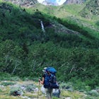
From the parking lot there are a few trails that branch left and right and eventually converge a short distance up ahead. The entire McGee Creek Canyon trail is smooth, wide, and easy to follow even with some snow. You’ll start out close to 8,000 ft. and its first mile takes you through a high alpine desert until you reach an aspen forest where you’ll find Buzztail Spring.
At 2.5 miles you’ll reach your first creek crossing over two large, lopsided logs armed with hand ropes for extra support. This is your first of three crossings – and in high water periods (Spring, after a storm) – these sections can be tricky. Another half mile ahead the trail slopes flat around a large pond with Mt. Crocker looming ahead.
The trail continues flat to mile 3.5 where you’ll cross the creek again over two much sketchier logs where you’ll want to exercise extreme caution – these were crooked and awkward when I crossed them in November of 2016. From the other side, you’ll slog upwards through a forest and farther away from McGee Creek. A mile later, around 4.5 miles from the trailhead, you’ll hit a fork in the trail and want to veer left (east) where you’ll hit your final log crossing. From here you’ll follow the steep switchbacking trail all the way up to your destination.
After 5.75 miles you’ll reach Steelhead Lake at 10,350 feet, tucked away beneath stunning walls of granite. There are plenty of camping spots along the shore, and even better places to stop and enjoy a picnic lunch before either continuing on up the trail or returning back through the canyon.
If you’re feeling up to a bigger challenge, you can continue on up the trail all the way to McGee Pass at 11,895 ft. for a total length of 20 miles roundtrip and almost 4,000 feet of elevation gain.
Cell service ends almost as soon as you get off of 395, so be sure to pack a map and other navigational tools. Check out the Mammoth Trail site to download a map before you go.
Download the Outbound mobile app
Find adventures and camping on the go, share photos, use GPX tracks, and download maps for offline use.
Get the appFeatures
Hike to Steelhead Lake through McGee Creek Canyon Reviews
The creek was swollen so we had trouble crossing (the bridge was collapsed due to a washed out bank) but we made it across. We couldn’t make it across the 2nd crossing so we set up camp. We stayed there for 2 nights and did some great fishing and scrambling. I would recommend going later in the summer and bring a misquote net! Overall we had a great trip with some of the most spectacular views!
5.0
Leave No Trace
Always practice Leave No Trace ethics on your adventures and follow local regulations. Please explore responsibly!
Nearby

Backpack to Red Slate Mountain

Photograph the Fall Colors of McGee Creek
")
Summit Mount Baldwin (12,614')

Fishing at Convict Lake

Convict Lake

Relax at Laurel Lakes
Community
Mobile Apps

© 2024 The Outbound Collective - Terms of Use - Privacy Policy