
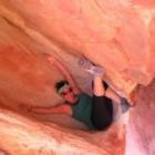
Alamere Falls via Palomarin Trailhead
Bolinas, California
Details
Distance
13.54 miles
Elevation Gain
1614 ft
Route Type
Out-and-Back
Description
Added by Jake Young
Head out to Alamere Falls via Palomarin Trailhead located near Bolinas, California. This trail will take you to a 40’ waterfall (tidefall) on the coast of Point Reyes National Seashore.
Alamere Falls is the tallest waterfall in the bay area. It is known as a tide fall because it empties directly into the Pacific Ocean. This is extremely unique because there are only 34 tide falls in the world and two in California, the other being McWay Falls in Big Sur. Enjoy stunning views of the pacific combined with varying terrain through forests, tall brush, and exposed dirt trails. If you hike to falls during the summer, take a swim in Bass Lake on the way back to the trailhead.
Best Time to Hike Alamere Falls
The trail is open year-round unless closed due to special restrictions (see nps.gov). The parking area can get very crowded, especially on weekends, so best to get there before 8am (and on a weekday) if possible.
The Hike
The hike to Alamere falls is a 13.5 mile out-and-back trail through the Point Reyes National Seashore. The trailhead is located in Bolinas, California just about an hour north of San Francisco over the Golden Gate Bridge. Please note, dogs and drones are NOT permitted on this.
Start at the Palomarin Trailhead located in the parking lot near the restrooms and head out on the Coast Trail. After about 2 minutes on the trail, you'll see a map on your right that lays out the trail to the falls as well as a few campground (Sky, Wildcat, etc.). Don't be afraid to take a picture of the map if you're worried about getting lost or bring a copy of the map from the NPS website (it's never a bad idea to have a paper reference). From there, the trail continues on the Coast Trail and is pretty straight forward as you head to the falls. For the first couple of miles, the trail is fairly exposed and can get warm on sunny days. The second half of the hike prior to reaching the coast is covered and wooded.
Approximately 3 miles into the hike you'll see signs for Bass Lake. This is a great spot to stop for a second and get drink or snack. Keep this place in mind as you may want to jump in to cool off on the way back! From here, you'll continue on the Coast Trail until you pass Wildcat Lake and arrive at Wildcat Camp for a total of 5.5 miles.
From Wildcat, you'll hike south for approximately 1.25 miles along the beach back the way you came. It's important that you check the tide levels before heading out on this trail to make sure that you're going while the tide is heading out and is sufficiently low. Visit NOAA.com for current tide projection for Point Reyes National Seashore.
To get back the parking lot, simply head back to Wildcat Camp and then hike back along the Coast Trail.
Trail Shortcut
There is an optional shortcut to this hike, but it is NOT sanctioned or maintained by the National Park Service. There is a small trail off the left of the Coast Trail when heading to the falls. with shrubbery and potential for contact with poison oak. As you get to the top of the falls, there are two steep parts that require some scrambling. The first takes you just above the main part of the falls, where there are a few smaller waterfalls. From here, head further down the trail to get to the beach; this is where the main waterfall is located. This last descent is slippery with loose gravel and can get very crowded at times making this a very challenging area.
Keep in mind that to help maintain the natural area around the falls and to ensure a safer hike for you and anyone with you, the National Park service recommends that you hike to Wildcat Camp and then take the beach south back toward the waterfall. Once you get to the falls, take in the scenery, snap a few photos, and refuel, then you'll have to scramble back up to the Coast Trail and head back the way you came.
What to Bring
- The 10 essentials for hiking
- Make sure you have enough water for a day hike: 2-3 Liters as well as enough snacks
- A large portion of this trail is unshaded, so you'll want to bring a hat, sunglasses, and sunscreen
- There may be poison oak and ticks along the route, so long pants are preferable
Camping
If you wish to make this an overnight adventure and camp at Wildcat Camp, you will need to get permits online or visit a Point Reyes National Seashore Visitor's Center. Wildcat Camp has (3) up to 4-person campsites, (2) up to 6-person campsites, and (3) 7-25 people group campsites.
Post Adventure
If you're looking to grab a bite after this long trek, head to Mill Valley, specifically Avatars for some Punjabi burritos.
Getting There
From Shoreline Highway, head south on Olema Bolinas Rd for 1.3 miles. Then, turn left to stay on Olema Bolinas Rd for 0.5 miles. Next, turn right on Mesa Rd for 4.5 miles until you reach the parking area.
Tips
- Remember to go early or during a weekday to get a parking spot. Cars that are parked improperly are often ticketed.
- The last mile driving up to the parking lot on Mesa Rd in Bolinas has many potholes, so higher clearance vehicle with AWD is preferred
- Palomarin Trailhead has pit toilets and a trash can
- Remember to check the tide levels before hiking from Wildcat Camp to Alamere Falls to ensure a lower tide and more accessible coastline
- This is not a family-friendly or dog-friendly hike given the restrictions, distance, and full-day of hiking
- If you want to make this an overnight trip, check the NPS website for updates on available campgrounds as well as permits
Conclusion
Seeing Alamere Falls is truly unique experience...after all, there are only 34 tide falls in the world! If you head out on this trail, make sure you give yourself plenty of time, check the tide levels, and please practice Leave No Trace principles.
Download the Outbound mobile app
Find adventures and camping on the go, share photos, use GPX tracks, and download maps for offline use.
Get the appFeatures
Alamere Falls via Palomarin Trailhead Reviews
good hike--i'd definitely do it again. it wasn't too challenging, but got some decent mileage in! the weather was perfect!
4.0

One of the cooler hikes I've done in the Bay Area. Be careful on the final scramble down to the beach - lots of loose rock, so take your time. Would not recommend it if you're bringing little ones along.
5.0
Leave No Trace
Always practice Leave No Trace ethics on your adventures and follow local regulations. Please explore responsibly!
Nearby

Bass Lake via Palomarin Trailhead

Point Reyes' Wildcat Camp via Coast Trail

Glen Camp Loop via the Palomarin Trailhead

Backpack to Coast Camp in Point Reyes via Palomarin Trailhead

Bolinas Ridge Loop

Swim at the Inkwells
Community
Mobile Apps

© 2024 The Outbound Collective - Terms of Use - Privacy Policy