
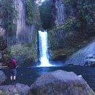
Hike Mount Saint Helena
Calistoga, California
Details
Distance
10 miles
Elevation Gain
2100 ft
Route Type
Out-and-Back
Description
Added by Nicole Mason
The highest point in Napa Valley! There are great views from the top across the Napa Valley, over to Berryessa, South to Mt Diablo, West to Mt Tamalpais, and supposedly even Lassen Peak to the North. You also pass the site of an abandoned mining camp where Robert Louis Stevenson honeymooned with his wife the summer of 1880, during which he wrote The Silverado Squatters.
Drive north from Napa following Rt 29, through Calistoga and up into the forest. After passing the sign for Robert Louis Stevenson State Park, and just over the crest, there is a parking area on the right side of the road, opposite the trailhead on the left. Parking fills up by mid-morning so get there early (and beat the heat!) If you're biking up, continue a short way down the hill to the next parking area which will start you at the base of the fire road.
The first mile is along a pleasant wooded switchback path to the site of a cabin where Robert Louis Stevenson spent a summer with his wife. The cabin is gone but a lovely clearing remains. Continue on the trail to the right up to the fire access road. You can't get lost from there - just follow the road the whole way up. You will go through some major switchbacks during the steady 4-mile uphill hike. It can be rather unpleasant in the heat of the day, so start early or bring a friend to draw your mind off the slog.
At one of the major switchbacks you'll notice a bolted crag in front of you called "The Bubble." A lot of climbing there and wrapping around to the side.
After 4 miles you'll come to the summit saddle and a leg of the road will peel back to the South Peak. Don't take it and keep following the road straight, heading for the peak behind the bubble-top communications tower. The road ends at the north peak, amid more towers but with awesome views of the valley. Give yourself some time to relax and take it in. You can see the geothermal power plant and the extents of the Lake County Fire, as well as numerous peaks and lakes.
Head back the way you came.
Download the Outbound mobile app
Find adventures and camping on the go, share photos, use GPX tracks, and download maps for offline use.
Get the appFeatures
Hike Mount Saint Helena Reviews

This hike had been on my bucket list for quite some time, you can see Mt St Helena from a majority of other hikes in the bay area so I just had to check it out. It's mostly along a fire road to the top. We went on Christmas day 2015 and there was quite a bit of snow! If not for that I think it would be a bit of a boring hike up. But, the views at the top are worth it, at least once!
4.0
I recommend you take two trips here. Both sides offer amazing hikes and views. Table rock makes you feel like your on the moon with a very big drop off. But so beautiful. Hiking to the top of St. Helena offers stunning 360 degree views of California. All the way to the pacific. I have heard on a very clear day you can even see the Golden Gate Bridge. I myself have not but I can believe it. Do yourself a favor. Get out and just go
5.0
I've been in napa 12+ years and on this trail (o.k. read: fire road) many times in all seasons. It's never seemed too croweded or full of mountain bikers like other places can be in parts of the Bay Area. Best time of year is spring or fall, if you go in the summer I suggest go very early in the day, because it's 'exposed' much of the day. Bring sunblock and extra water. Here's the State Parks link: http://www.parks.ca.gov/?page_id=472
5.0
Leave No Trace
Always practice Leave No Trace ethics on your adventures and follow local regulations. Please explore responsibly!
Nearby

Hike the Oat Hill Mine Trail

Hike Bald Hill in Robert Louis Stevenson State Park

Camp at Bothe-Napa Valley SP

Gunsight Rock via Hood Mountain Trail

Creekside Trail to Canyon Trail to Ridge Trail Loop

Hood Mountain Summit Via Lower and Upper Johnson Ridge Trails
Community
Mobile Apps

© 2024 The Outbound Collective - Terms of Use - Privacy Policy