
Backpack to Coit Lake
Morgan Hill, California
Details
Distance
26 miles
Route Type
Out-and-Back
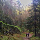
Description
Added by Ashley Chang
A beautiful backpacking route within driving distance of SF. Get permits once you're there and explore the diverse landscape of this large park!
This trail can be started from Coe Headquarters or Hunting Hollow Trailhead. The trail from Coe HQ is 2 miles longer, almost all elevation but provides beautiful views of the surrounding mountains. These directions will be starting from Coe HQ.
Follow the loop around the parking area to the backpackers parking during high season. If the park isn't busy you can park anywhere that isn't "20 minute parking". You can self-register at the iron horse, or go into the HQ to get a permit, you'll need to leave it in your car!
Take Manzanita Trail from the parking lot. This is an easy downhill walk for ~2 miles. Take this to Manzanita Point, and then turn down ____ and continue to a small pond, (and water source!) at China Hole. This will be at the base of the mountain surrounded by large rocks.
From China Hole continue along on Creekside Trail to Los Cruzeros. This is a campsite if you'd rather break the trip up into three days of walking! There is usually water here, but it's been low due to the drought recently.
Take Willow Ridge Trail up a the mountain from here. This is ~2.5 miles uphill. Near the end you'll pass the Willow Ridge campsites. There is a small man-made spring in one of the campsites where it's possible to get water, although these campsites lack the view that other options have.
This trail will reach Willow Ridge Road, a much larger path where you will take a right. From this point it is 5.2 miles slightly downhill. When you reach a small pond on the right, take the .3 mile path on the right directly to Coit Lake! This road goes past a bathroom, if you continue about 100 meters there is a path on the right up to a campground on a small hill above the lake, and several other campground spaces!
Check water levels on the park's website before heading out!
- On the way back it's possible to take Poverty Flat Road as a shorter route instead of going to China Hole. This path is VERY STEEP and long, so be ready for a calf workout!
Download the Outbound mobile app
Find adventures and camping on the go, share photos, use GPX tracks, and download maps for offline use.
Get the appFeatures
Backpack to Coit Lake Reviews

I did this trip in 2015, but still think about how much fun I had. The terrain is difficult, great for conditioning, and pretty spectacular to look upon. It is surreal to think we can have this vast open space so close to the Bay Area. I highly recommend this trip! I did it in two days, but wish I'd stayed longer. I had fun walking uphill, saw a mountain lion, and enjoyed gazing at the stars.
5.0
This trip is pretty difficult because of the crazy elevation changes but totally worth it. Hiked 11 miles in on the first day and wouldn't recommend it. This really should be a 4 day hike.
5.0
Leave No Trace
Always practice Leave No Trace ethics on your adventures and follow local regulations. Please explore responsibly!
Nearby

Backpack to Mississippi Lake

Redfern Pond via Hunting Hollow

Stargaze at Lick Observatory

Explore Santa Teresa County Park

Uvas Canyon Waterfall Hike

Mountain Bike Soquel Demonstration Forest
Community
Mobile Apps

© 2024 The Outbound Collective - Terms of Use - Privacy Policy