
Detours Worth Taking along Your Drive to the Yukon or Alaska
Bring your sense of adventure, charge up your camera, and be ready for one of the most memorable road trips you’ll ever take.
Officially, the Alaska Highway is a paved 2234 km (1388 mile) long ribbon of highway that runs from Dawson Creek, British Columbia into Delta Junction, Alaska via the Yukon. Driving north is one of those bucket list drives that most people have on their wish list of scenic road trips. Much like Route 66 in the American Southwest or Highway 101 along the Pacific Coastline, the Alaska Highway is both iconic and legendary as it cuts through a sprawling wilderness amongst boreal forest covered hills and mountains that give way to crystal clear lakes that look nearly untouched.
It’s a highway where you’re more likely to see a bison or a bear grazing along the roadside than ever encounter a traffic jam. It’s a highway for when you are itching for adventure and looking forward to leaving the city life behind. Spanning an incredible distance, it’s also a route that leaves most folks wondering where even to begin when planning a road trip north.

Pictured: Grizzly Bears at the Yukon Border
In times without Covid, RVs, converted vans or anything with an engine all start heading north as soon as the snow begins to melt in May. It won’t be until June that the ice thaws off the lakes but the days grow longer with every kilometre driven northward and the opportunities to get out in nature explode exponentially the further one goes. The summer season is short, with the frost on the ground early mornings causing the leaves to turn colour in late August and by the end of September, those same RVs and vans have all made their way south with not a leaf left standing on any tree in sight.
With that small window of opportunity and an immensely large territory to cover, it’s important to know where you’ll want to stop and how best to get going north. It’s worth it as well to realize there are more routes than just the Alaska Highway, and I’ll start by explaining which way north is most ideal.

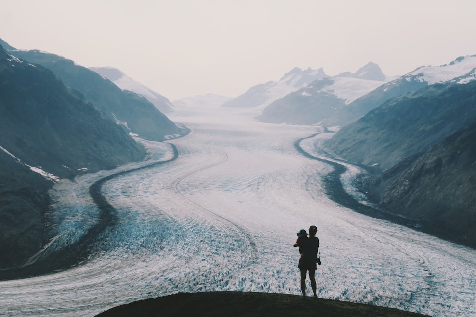
Pictured: Kluane National Park, Yukon
Can I travel to the Yukon and Alaska via BC right now?
Bear in mind that restrictions exist in 2020 due to Covid19. At the time of writing, the Province of British Columbia is lifting the ban on non-essential travel for residents of the Province, while the Yukon Territory as of July 1 will be accepting residents of British Columbia, Northwest Territories and Nunavut into the territory. As of writing the border between the USA and Canada remains closed to non-essential travel.
Both BC and Yukon are requesting that people travel responsibly and respectfully to the communities they plan to visit. Many of the listed communities below are home to self governing First Nations, take the time to learn about the cultures and histories of the peoples land you are visiting.
If you are planning your travels in 2020 or beyond, it is always worth reaching out to the local tourism information centre for the latest information on closures and openings within that community.
Destination BC Contacts:
https://www.hellobc.com/plan-your-trip/visitor-information-services/
Travel Yukon Contacts: https://www.travelyukon.com/en/plan/travel-information/visitor-information-centres
Travel Alaska Contacts:
https://www.travelalaska.com/Contact/Community-Links.aspx
The following has been written for your inspiration and information based on times when all restrictions will be lifted. This is not a guide of what to do when you reach Alaska, just what to see on the road going there, by taking the most direct routes possible. This is also not a guide of what to see or do in Southern British Columbia.
This is strictly meant as a piece of where to go in Northern BC while you are clearly on the road to Alaska and the Yukon.

Pictured: Views from the Alaska Highway, Yukon
By land or by sea?
The Alaska Marine Highway links up Southeast Alaska, the Panhandle, with Canada via the Prince Rupert Terminal. As one would expect, the sea route is anything but direct and will call in at ports in small inlets and on small islands as it crosses the inside passage northward.
Expect to take three days to make it to Juneau and another three at least if you try to get to the mainland of Alaska. You won’t be sailing in luxury, but you’ll share the view with humpback whales, orcas, otters, seals and eagles while sleeping on the floor if you are on a budget and can’t splurge for a cabin. Don’t expect to be raving about the cafeteria food and be warned you’ll be hearing about your arrival at each port of call you land at over the loudspeaker even if it occurs in the middle of the night.
By land, you’ll have two options to get to the Yukon. The Alaska Highway mentioned above was the original road built in a hurried 8 months during the second world war when the US thought a Japanese invasion was imminent. Or, the Stewart Cassiar Highway built in 1975 and running along the western corridor of BC. Everyone who has travelled the highways will have their preferred road which is a good indicator that both are worthy of exploring. Luckily, they can be done in a loop and backtracking is not needed.

Pictured: Salmon Glacier, BC
Detours you need to see to believe.
If you venture along the Alaska Highway long enough, you’ll get to experience first hand how remarkable this massive project was. Completed in 1942 by southern soldiers who started on opposite ends thousands of miles apart as the snow was still on the ground, and worked their way through summer and somehow ended up meeting in the middle. 10,000 men were brought to the region and the simple tools they used somehow got the job done. It was a rough road that was hardly used in the early days, but the muddy tracks called on adventurers then as it does now. Luckily for us, the surface has thankfully since been paved and amenities are a little more plentiful than post war times.
Take a moment in Dawson Creek to enjoy the Mile 0 Signpost and the wooden Kiskatnitaw River Bridge that curves high above a river at mile 21 just up the road. If you have more than a few moments, get off the Alaska Highway completely and drive south to Tumbler Ridge, 117 km south on the Heritage Highway and the gateway to Monkman Provincial Park. The town itself was built on a bounty of natural resources, from coal to uranium, and the area can be explored by zig-zagging down the far reaching forestry roads that lead to dinosaur tracks, countless biking and hiking trails to scenic waterfalls, but just watch out for the machinery. Monkman is a park within the foothills of the Rocky Mountains with a waterfall that is higher than Niagara, and far more impressive.

Pictured: Monkman Provincial Park, BC
Once you are heading north again, it’s a long drive until you reach the next set of highlights, Muncho Lake and Stone Mountain Provincial Park. Honestly, up until this point you might be wondering if the Alaska Highway is just a collection of industry towns with some old timey museums, thankfully once one reaches these two provincial parks, the beauty of the highway becomes obvious. The road twists and turns at this point, climbing into the subalpine where mountains soar from the edge of the highway and forests finally seem untouched. Whether it is fishing holes or hiking trails you’re after, one could spend days paused in the area. There’s an information centre and an adventure outfitter all situated in a fine looking lodge right on the shore of Muncho Lake for those looking to spend time in the area.
If you end up making yourself weary with exercise or just aching from the long journey north, you’ll love a stop at Liard Hot Springs. Resembling a creek with a gravel bed floor, the springs are surrounded by boreal forest, and range from inexplicably hot to cooler as you follow the creek down. Spend the night in the provincial park campground on the edge of the wetlands so you can get access to the hot springs throughout your stay or just obtain a day pass for a quick dip.

Pictured: Bison or buffalo near the Yukon border
Watch the road for the next section, we counted 88 bison and 23 bears in quick succession between Liard and Watson Lake. Bison (or buffalo) are the largest mammals still naturally roaming North America, and with the good grazing at the side of the highway they seem completely unafraid of cars. You’ll undoubtedly have a memorable encounter, but don’t feed the wildlife or get too close.
Watson Lake is the next stop, and becomes your introduction to the Yukon with quirky sights such as the Sign Post Forest as well as pristine lakes that provide great fishing. Sure, you could jump in for a swim, but if you haven’t discovered from the journey this far, every lake is take-your-breath-away brisk and only for the brave. From here, you can pull on over to any of the territorial campgrounds, and relish in the fact that it is some of the cheapest camping you’ll ever find and warm up with chopped up campfire wood included in your nightly rate.

Pictured: Atlin, BC
Before you make it to the territorial capital, venture south for a side trip to Atlin, BC to take in the pioneer town that feels like it hasn’t moved a day past the gold rush era. Truthfully, it hasn’t. It was accessible only by boat until the great depression of the early 20th century killed tourism and left the town cut off for decades only to be used as a base for miners. Although it has a paved road connecting it to the Yukon, there is still no cell service and most locals are happy to talk your ear off.
Atlin Lake is a frigid beauty which is home to the world’s tallest mountain on an island in a fresh water lake. Yes, that’s a thing. At the far south of the lake are also glaciers that connect to the Juneau Icefield and are reached by multi-day kayak and a hike for those so inclined.
Once you get your fill of Atlin, keep on the scenic route by taking the Tagish Highway to Carcross. If Watson Lake’s quirk didn’t win you over, discover the larger than life appeal by grabbing a bite to eat at Southern Lakes Resort before renting a canoe and paddling the calmer section of Windy Arm. Jagged mountains, endless forests and an emerald green lake will be all you can see in any direction.

Pictured: Carcross, Yukon
After your adventure, head west and pause in the tiny village of Carcross. Carcross has made a name for itself as a mountain biker’s paradise and also has the White Pass & Yukon Route train that connects to Skagway, Alaska for those looking for a little less adrenaline in their sightseeing. Officially, the village’s name is short for Caribou Crossing, which also happens to be the name of a great cafe in the ‘Commons’, a group of buildings all covered in murals of native art. Did I mention there is also a beach, some of the best hiking in the territory, and the world’s smallest “desert” here too? Make sure Carcross is on your list to see.
After this, head towards Whitehorse and soak up the metropolis atmosphere of the wilderness city. Grab a beer in one of the four local breweries, treat yourself to a good meal out and hit the trails or rivers. Seven hundred kilometres of hiking and biking trails surround the city centre, while the famous Yukon River runs right beside the downtown core and has a few outfitters that will let you put in a canoe from downtown and then pick you up further downstream. This 3200 km long river is one of the continents most famous, once the commute for thousands of ill-fated gold mining prospectors on their way to the Klondike, and is now a source of entertainment for day paddlers and week long adventurers alike.

Pictured: Yukon River, Yukon
Once your belly is full, you’ll have to decide your best route for getting to Alaska. Officially there are four ways. Route 1 via the White Pass into Skagway. Route 2 via the Haines Pass into Haines. Both are utterly scenic, connected to the Alaska Marine Highway and can be completed as a loop if you book a ferry between the two American towns. The 3rd route heads north on the Klondike Highway following the rolling hills of the gold rush trail to Dawson City and eventually onto the Top of the World Highway. As the former capital of the Yukon, Dawson has charm that looks straight out of a movie set. Dirt roads, wooden boardwalk sidewalks, meticulously kept 1900s era buildings, a gambling hall and a dive bar that gives you a shot with a fermented toe in it. It’s also the closest city to another highway (the Dempster) that heads to the Canadian section of the Arctic Ocean via one of the Yukon’s most prized parks (Tombstone).

Pictured: Haines Pass from above, BC + Alaska
Most will take the route to Alaska following the Alaska highway through Kluane National Park, home to the largest non-polar icefield, many top hiking trails on alpine ridges, remote paddle trips past tumbling glaciers and epic views right from the wildflower-lined highway. Think of having the beauty of Banff without the crowds. From Haines Junction, head northwest by following expansive Kluane Lake past the potholes over a section of highway that slumps with the permafrost melt but has many scenic lookouts to make it worth stopping. From here, you’ll be in Alaska in no time.
When the time comes to return, or perhaps begin here and do the Alaska Highway in reverse, you’ll have the other option of driving the Stewart Cassiar Highway. The road connects with the Alaska Highway just after Watson Lake and well before the turnoff for Atlin. It’s nearly 900 km long and also incredibly scenic, arguably more so than the Alaska Highway route it replaces. Like all other routes mentioned, amenities are further from one another than most southerners are used to so keep an eye on that fuel gauge and snack pile.

Pictured: Boya Lakes Provincial Park, BC
Make time for a stop at Boya Lakes Provincial Park, a series of limestone-bottomed lakes with small islands and a maze of inlets that could be confused for being tropical if photographed from above. It’s the closest thing resembling swimmable, and the parks board offers canoes for rent that I’d highly recommend taking. One could detour towards Telegraph Creek in this region, as well for some other-worldly landscapes like that of Mount Edziza stratovolcano, or the Sacred Headwaters alpine basin that births three of BC’s greatest rivers but be warned the road is rough to Telegraph Creek and a forest fire altered the region greatly in 2018. The other regions require a helicopter to access and plenty of backcountry experience.
If there is only time for one detour on this route, make it the 64 km (40 mile) access road to Stewart and Hyder that has to be one of the world’s best. Hanging glaciers tumble from their mountaintops and dense rainforests are cut by cascading waterfalls making this spot as dreamy as it is remote. The friendliness of the towns at the end of the road with bear-filled boardwalks along the river and estuaries is memorable to say the least.

Pictured: Nass Valley, BC
Equally worthy, a detour on the Cranberry Connector to the Nass Valley shows the impressiveness of Indigenous tourism and infrastructure built for crowds but lacking any. A world class museum, cozy cedar tubs at the hotprings, the chance to see spirit and grizzly bears, as well as a sprawling lava bed that erupted with little warning relatively not long ago, will give you enough to look at to spend a full day or two at the very least in the region.
Continuing with the cultural explorations, pause at the totems at Kitwanga, the last (or first) stop on this highway which inspired paintings by famed artist Emily Carr.
From here you’ll have to decide if you head east or west. If heading east, take a tour with a First Nation guide at the rebuilt Ksan Historical Village, get a bite to eat in a village locked in time in the Hazeltons, and feel the mountain vibes with a trip to either Hudson Mountain or the Babine Mountains in Smithers.
If you go west, you’ll venture through the rainforest covered granite cliffs that follow the salmon rich Skeena River all the way to Prince Rupert before taking the (more luxurious than the American counterpart) BC Ferries Inside Passage cruise down to northern Vancouver Island.
Whatever you do, bring your sense of adventure, charge up your camera, and be ready for one of the most memorable road trips you’ll ever take.

Pictured: Unknown lake on the way to Alaska
Curious about any of the destinations I mentioned above or feel there was something I missed? Send me a message and follow along our family adventures in the Yukon in real time on Instagram @meandertheworld.
We want to acknowledge and thank the past, present, and future generations of all Native Nations and Indigenous Peoples whose ancestral lands we travel, explore, and play on. Always practice Leave No Trace ethics on your adventures and follow local regulations. Please explore responsibly!
Do you love the outdoors?
Yep, us too. That's why we send you the best local adventures, stories, and expert advice, right to your inbox.


