
Bob Webber Trail
Cammal, Pennsylvania
Details
Distance
3.63 miles
Elevation Gain
1424 ft
Route Type
Out-and-Back
Description
Added by Eric Beiter
Bob Webber Trail in the Wolf Run Wilderness Area is a great hike when you want a quick challenge.
To get to the Bob Webber Trail, start by heading up one of the most beautiful valleys in Pennsylvania: Pine Creek. Shortly after Waterville jump onto 414 and enjoy the drive past Cammal. About one mile after Cammal you will come to the Ross Run parking area on the left and you are there. The Bob Webber Trail starts across the road opposite the parking entrance. The trail is an out-and back route that is 1.7 miles one way, 3.4 round trip. It is named after a retired PA forester, Bob Webber, who blazed more than 50 miles of trails in the surrounding woods.
When you start up the trail you are immediately given a small taste of what it is going to be: a climb. It levels off for a short distance and then as the trail takes a right back up the mountain you begin to climb at a steep pace. The second climb is not the hardest either so do not waste all your energy sprinting through it. Relief comes in the sign of moss grown over the trail, when you reach that point you get another break, even a little down hill.
Before you start to head further up the mountain you do have to option to check out Pine Cliff Look Out (just keep going straight instead of right). Once you decide to continue watch your footing. The trail is now very rocky and will require you to pay attention so you do not slip. Keep a lookout to your left (in fall, winter, and early spring) you will be able to see the Ravenshorn of the Golden Eagle Trail. The incline remains modest through the rocky steps and as it had before will flatten out. This however ends soon.
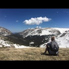
The final and hardest part of the trail is that which contains the switchbacks to the summit. They get progressively shorter and shorter and a bit steeper as you climb. If you need to near the top of the last rock formation you can take a detour to the Twin Springs Rest Area for some water. After the rock formation you can enjoy the rest of the hike to the lookout while catching your breath.
Download the Outbound mobile app
Find adventures and camping on the go, share photos, use GPX tracks, and download maps for offline use.
Get the appFeatures
Bob Webber Trail Reviews

The trail is named for a local legend, google his name, learn about him and then hike this trail and enjoy some beautiful views.
4.0
Beautiful trail with tall evergreens. Most of the trail is at an incline with a gorgeous view. There's a field of blueberry bushes at the top, but be cautious if you decide to pick them..... they're many bees ready to ATTACK.
4.0
Leave No Trace
Always practice Leave No Trace ethics on your adventures and follow local regulations. Please explore responsibly!
Nearby

Hike the Golden Eagle Trail

Hike the Hemlock Mountain Loop

Hike the Gas Line Ridge Loop

Backpack the Black Forest Trail

Hike the Ruth Will Trail

Blackberry to Black Forest Trail Loop
Community
Mobile Apps

© 2024 The Outbound Collective - Terms of Use - Privacy Policy