
Nippletop, Indian Head, Gothics
Keene Valley, New York
Details
Distance
21.55 miles
Elevation Gain
7631 ft
Route Type
Loop
Description
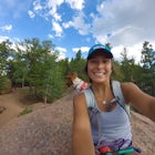
Added by Tim Zeblisky
This beautiful loop in the High Peaks area of the Adirondacks will overwhelm you with beautiful mountain scenery, and is a great choice to avoid crowds which can sometimes be found on some of the other popular high peaks.
We completed this loop over the course of 3 days in late June, however for those who pack extraordinarily light and/or travel extraordinarily fast, this loop could be completed in 2 days. There are also a plethora of trail intersections to either extend or shorten your loop to different preferences. Also, please note that there are specific regulations for hiking and camping in the High Peaks and on the Adirondack Mountain Reserve, which can be found here, here, and here.
Begin at the Saint Huberts Trailhead Parking Lot (1,263ft), which is for the general public. This loop begins on the private land of the Ausable Club, so this is as far as you will be able to take your car. The first 3/4 of a mile will be on a road, taking you past houses and a golf course, and give you your first glimpse of the peaks you will tackle over the course of the next couple of days. Take a left onto Lake road, and at the 3/4 mile mark you will see a gate made of boughs that says "AMR" on it. Near that there is a trail registry and a ranger office. Be sure to sign in before continuing.
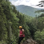
After passing the gate, stay on lake road for a little over 1/2 mile and then take the left trail that directs you towards Dial and Nippletop. This trail will take you over Bear Den Mountain (2,650 ft), which you may pass by and not even notice. However, if you keep your head up and start to notice peaks pop up over the trees, keep your eyes peeled for a vista just off trail which will give you amazing panoramic views of Gothics, Armstrong Mountain, and the Wolfjaws, among other peaks.
Continuing along the same trail will lead you to Dial Mountain (4,003 ft). The summit of Dial is pretty heavily wooded except for a boulder, which provides more westward views of the places to be conquered in the next few days.
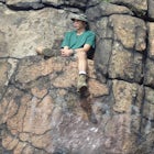
The trail will continue to lead you towards Nippletop (4,620 ft), the last peak of the day. The climb up Nippletop seemed to move much faster than the climb up Dial, so don't be discouraged by the climb up Dial if it feels like it takes forever. Eventually, you will reach a trail intersection, one of which leads to the summit, and the other leads down the mountain. Obviously take the trail that leads to the summit, you wouldn't wanna climb all that to not have a view. From Nippletop, there are beautiful views west and south from a clearing. If you sneak through the trees on a very short path, you will be led to an opening that provides awesome eastern looking views and you can see Dix Mountain, and even all the way to Vermont on a clear day. Once you have soaked in enough of the view, make your way back down to the trail intersection. Once there, begin your descent on the trail that leads to Elk Pass. This takes you down the steep side of Nippletop where there are some ponds at the bottom. Once you reach the bottom of the decline there is a marked campsite right next to one of the ponds. That is where we camped on the first night. We were accompanied by a couple and we were able to fit both our and their tents comfortably in the space. There may be other campsites nearby, there are certainly other spots to camp nearby. If you don't camp in a marked site, make sure you are somewhere around 150 ft from the trail or pond.
The next morning, continue on the same trail. It will lead you around the ponds, and you will come to an intersection soon enough. Take the trail that leads towards Indian Head and Fish Hawk Cliffs. Keep following signs that lead you towards Indian Head and Fish Hawk Cliffs. You will come across Fish Hawk Cliffs first, granting you a sneak peak of the full view that Indian head provides up and down Lower Ausable Lake and the surrounding peaks. We found Indian Head to be a great place to stop for breakfast.
After passing Indian Head, continue on the trail which leads you to Lake Road. You will be on Lake Road for a very short period of time before crossing a bridge right near the dam at the north end of Lower Ausable Lake. At the other end of the bridge, you will have choices of different trails. Take the trail that directs you towards Sawteeth (4,150 ft) via the scenic trail. This should be the leftmost trail, leading you south along Lower Ausable Lake. Along this trail, you will be presented with lakeside views and views of Indian Head and Fish Hawk Cliffs before ascending up towards the summit of Sawteeth. There are several outlooks along the way up the trail, looking out at Indian Head, Fish Hawk Cliffs, Mt. Colvin, Blake Peak, Nippletop, Giant Mountain to the North, and of Upper Ausable Lake to the South. The summit of Sawteeth Gives you a good first look at the western High Peaks, and it also shows you where you're going next. Pyramid Peak (4,515 ft) and Gothics (4,736 ft) are laid out right before your eyes. Pyramid is considered a sub peak of Gothics, but the views are said to be some of the best in the Adirondacks. It provides 360° views of the breathtaking scenery. You can see where you came from, where you're going, and everything in between.
Coming down from Pyramid Peak, you can see Gothics coming closer and closer until you hit the saddle and begin your climb up. Gothics has equally amazing views. From Gothics, you can also decide to extend your trip from there. There is a lean-to at Ore Bed Brook, along with tent sites, taking the trail that leads west, or you can continue along the loop towards Armstrong Mountain. We continued towards Armstrong Mountain and decided to descend below 4,000 ft in elevation between Gothics and Armstrong and create a minimal impact primitive site with just enough room for our tent. A pro to this is that it does not add distance onto your trip, however a con is that you will need to do some searching and make sure you are abiding by the rules in order to minimize your impact. We were able to hike up to Armstrong (4,446 ft) from our campsite to see the sunset which was magnificent, especially since we got a little rain prior. Be sure to bring your flashlight if you do this!
The next morning we got an early start and continued up Armstrong, then continued onward to Upper Wolfjaw (4,203 ft), which provided beautiful views to the east, looking out to Bear Den, Dial, Nippletop, Dix, and Giant.
Coming down from Upper Wolfjaw, we made our descent back into the valley. At the next trail intersection, we took the route that directed us back towards the West River Trail and Saint Huberts. This trail is gonna take you down and down and down some more. You will follow along Wedge Brook for a while before coming to the West River Trail, where you will take a left. From there, there are several river crossings you can decide to take to get back to the trailhead, however we took the first one at Canyon Bridge, which is indicated by the first trail intersection with a direction towards Lake Road. We crossed a nicely constructed bridge and followed signs back to Lake Road, which we then followed back to the parking lot. Be sure to find your page and sign out at the trail registry before leaving! As you leave congratulate yourself on bagging 8 Adirondack peaks (counting Pyramid Peak) in one shot!
Notes:
- Show up to the parking lot as early as you can. It will fill up quickly and spillover onto Route 73, especially on weekends.
- Trails will most likely have sections of deep mud. Be prepared for this and in spring time when there is snowmelt/a lot of rain that some trails may become difficult to pass.
- Review the rules and restrictions before going so you are not caught breaking them accidentally.
- Our camp was a dry camp on Day 2, and so we made sure to fill up before heading up to sawteeth from lower ausable lake, and then made that last until day 3 when we started following streams and then eventually reconnected with the ausable river. Plan ahead and bring extra water and/or plan meals that do not use a lot of water!
Download the Outbound mobile app
Find adventures and camping on the go, share photos, use GPX tracks, and download maps for offline use.
Get the appFeatures
Nippletop, Indian Head, Gothics Reviews

I ambitiously planned to do this whole loop over thanksgiving break this year, but had to cut it short and do only half. The climb up to nipple top from the road and down to elk pass is pretty grueling when theres 6-12" of snow and ice on the trail and I wasnt able to travel at my target speed so ended up doing 4 hours in the dark. In the end I opted to cut back and take the scenic trails back to lake road after camping at the elk pass campsite. Ill come back in the spring to do the whole thing... It was a beautiful hike nonetheless! The morning snow shining in the morning sunlight across the valley was enchanting
5.0
Indian Head is one of the most notable hikes and photoshoot opportunities in the Adirondacks! The hike is pretty strenuous, but very worth it. In the fall, it can get pretty windy and cold at the stop so bring layers!
5.0
The driving directions associated with this hike are good, except that the parking is at the more southerly of the two junctions of what is now posted as "Ausable Rd." and not "Ausable Club Rd." It is across the highway from the Roaring Brook access to Giant Mt.
5.0
Hi Jen! There are ladders, some pretty tall, not too much scrambling though. I think an experienced dog could handle it. The only complication is that hiking on the Adirondack Mountain Reserve has specific rules, one of which is no dogs unfortunately.
5.0
Hey Tim! Good info! I looked around, is this the same trail with some scrambling and a ladder? I plan on bringing my experienced pups with me.
5.0
Leave No Trace
Always practice Leave No Trace ethics on your adventures and follow local regulations. Please explore responsibly!
Nearby

Hike Indian Head and Fish Hawk Cliffs

Hike to Noonmark Mountain

Hike to Gothics Mountain, Pyramid Peak, and Sawteeth Mountain via Beaver Meadow Falls

Hike to Mount Colvin and Blake Peak

Climb Chapel Pond Slab

Hike Rooster Comb Mountain
Community
Mobile Apps

© 2024 The Outbound Collective - Terms of Use - Privacy Policy