
Backpack to Grouse Lake
Markleeville, California
Details
Distance
11.43 miles
Elevation Gain
2283 ft
Route Type
Out-and-Back
Description
Added by Anna Cohen
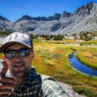
Hiking to Grouse Lake offers scenic mountain views and in the right season, you'll see an abundance of beautiful wildflowers.
It is a 6 mile hike to Grouse Lake. You begin at the trailhead which is right by Damsite Campground at Upper Blue Lake. Park in the dirt parking area and then cross the metal footbridge, and you will see the trailhead marker on your left.
The trail takes you into the Mokelumne Wilderness. Follow the trail about 2 miles, through forests and meadows, and you will reach Granite Lake. This is a beautiful lake to camp at, enjoy a picnic, or take a swim in.
Continue on, and the trail will wind up a series of steep inclines. You will cross rocky slopes and grassy hillsides. Granted that there is no fog impeding your view, you will be met with stunning vistas.
As you approach Grouse Lake, the trail will begin a steep descent. The lake is at the bottom of the trail, surrounded by beautiful rocks and cliffs. There are plenty of places to set up camp around the lake and there are lots of areas to explore from your camp. Go for a dip, or sprawl out on the rocks and enjoy the mountain sunshine.
The stars are incredible at night, so once the sun sets, get nice and bundled and look up.
Directions: To get to the trailhead, take the Hope Valley Road off Highway 88 to Lower Blue Lake. Then, turn north and go all the way to the south end of Upper Blue Lake, where you will find a dirt parking lot and the trailhead.
The GPS coordinates for Upper Blue Lake Campground are: Latitude: N 38° 37' 46.6606", Longitude: W 119° 56' 20.7889"
Download the Outbound mobile app
Find adventures and camping on the go, share photos, use GPX tracks, and download maps for offline use.
Get the appFeatures
Backpack to Grouse Lake Reviews

Great views at the top of deadwood peak, which is a short detour off the main trail. Some parts of the trail don't have clear trail markers, so make sure you're checking your map as you go. Really great and could definitely be done in a day! You could probably extend this trip a couple days if you want to hike out to the nearby lakes (Twin and Meadow).
5.0
This hike is a great overnight trip with excellent vistas into the massive canyons that make up the Mokelumne Wilderness. Best of all you can easily summit Deadwood Peak from the shoulder before descending to Grouse Lake. From the summit of Deadwood Peak it puts the massive size of these canyons into even greater perspective and you can see for miles up and down the Sierra Crest.
4.0
Moderately difficult but super rewarding, being the only human near that crystal clear mountain lake is awesome!
5.0
Leave No Trace
Always practice Leave No Trace ethics on your adventures and follow local regulations. Please explore responsibly!
Nearby

Snowmobile at Hope Valley Sno-Park

Hike to Round Top Peak

Hike The Sisters in the Mokelumnee Wilderness

Meiss and Round Lake via Tahoe Rim Trail

Hike Round Top Summit and Winnemucca Lake Loop

Climb Peep Sight Peak in the Carson-Iceberg Wilderness
Community
Mobile Apps

© 2024 The Outbound Collective - Terms of Use - Privacy Policy