
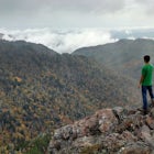

Hike to Lonesome Pine Overlook
Bryson City, North Carolina
5.0
7 mi
/ 2300 ft gain
To start the hike to Lonesome Pine Overlook begin from the Noland Divide Trailhead in Deep Creek. The trail is a steady climb with an average gain of 700 ft. every mile. Approaching the top you'll walk along a rocky ridge line where you are able to see the overlook. As you continue, be sure to look closely for the spur trail out to the overlook because the sign has fallen over.
From the overlo...

Explore Old 288 and the Lands Creek Bridge
Bryson City, North Carolina
2.5
1 mi
NC 288 was constructed in the 1920's, but did not last long with the construction of the Fontana Dam as the resulting lake covered the highway. The U.S. government entered an agreement in which they would provide a replacement road, but to this day it has not been completed and is know by locals as the Road to Nowhere. The consequence of the dam upon the highway and communities within the area ...

Day Trip to Lake Crabtree
Morrisville, North Carolina
5.0
Lake Crabtree is a 215 acre park that sits right next to a 520 acre flood control lake, known as Lake Crabtree. The park is open year round and offers a plethora of different activities. Hiking trails are accessible to hikers and runners while bikes are also permitted on multi-use trails. The park offers a public boat launch that is open year round and paddle boats, SUP boards and canoes are av...

Hike Three Waterfalls Loop
Bryson City, North Carolina
5.0
2.4 mi
/ 450 ft gain
Start the loop by hiking the Juney Whank Falls Trail to Juney Whank Falls. The footbridge across the creek makes an excellent place to rest and take in the falls. Follow the trail across the bridge and up the bank. After about 300 feet take a right and follow Deep Creek Horse Trail towards Deep Creek Trail.
After intersecting with Deep Creek Trail turn left and walk about half a mile passing T...

Hike to Alarka Falls
Bryson City, North Carolina
5.0
1 mi
/ 100 ft gain
To visit the falls, take US-74 west from Bryson City to exit 64 . Take a left at the exit and drive on Alarka Road for about 10 miles. Follow the road all the way to the end where you will find a turnaround. Don't make the mistake of following the forest service road (it is gated), as it is not the right trail. From the turnaround you will be able to see campsites. Walk through the campsites a...
Community
Mobile Apps

© 2024 The Outbound Collective - Terms of Use - Privacy Policy