
A Hike in the Highlands...of South Africa
Sun, clouds, forest, fynbos, lagoons and sea: two days of hiking in the Kogelberg Nature Reserve, Western Cape, South Africa.
They say change is as good as a holiday. Well, I wasn’t expecting my change to involve moving to the Eastern Cape to start a new job. But, thankfully, it meant that I sprang into action and organised a hike prior to leaving the Western Cape.
I wanted to do a 2-day hike, and I came across the Highlands Trail on the Hiking South Africa forum. A 39km 2-day hike, it looked ideal especially as we could leave our gear and food for the night at our accommodation in Kleinmond, which meant we only had to carry a day pack.
I chatted to some friends and we set a date: 27 July 2019.
My first multi-day hike (excluding Kilimanjaro), and my first time organizing something like this. I tried to learn as much as I could about the route, especially the lagoon crossing on Day 1. I also tried desperately to get some sort of trail map. Yes, I was completely over-thinking things, but as I was the one with the idea, I felt that I was responsible for making sure that everything went smoothly.
I booked our accommodation at The Grail Center, and sorted out our Cape Nature Permits. I even drove out to Kleinmond about a week before to scope out the lagoon. It looked do-able. That is, anything from ankle-deep to chest-deep! My friends didn’t seem too phased. I was getting worried as the “what if’s” flooded my mind.
Day 1 – 22km
Iona Farm to Kleinmond
We were 4 people in total and drove out to Kleinmond in two cars early in the morning of the 27th July. The weather was looking good and we were excited!
We would leave one car at The Grail Center, with our kit and food for the night. And drive the other car to the start of the hike, on Iona Wine Farm, about 18km from our accommodation on the Highlands Road.
Only, when we got to the Grail Center, we were informed the cottage we booked was ready. So rather than leaving food in cooler bags in the car, we could refrigerate what needed to be refrigerated and store all of our other stuff. And by checking out the cottage, we got to see what would be waiting for us at the end of our hike (comfy beds, a fire place, hot shower, and a braai (BBQ)!) Now that is service!
We then piled into the other car and headed for the Iona Wine Farm.
It’s a really beautiful area, and we were excited to get walking! It was relatively cool, but there wasn’t a breath of wind or a cloud in sight!

As I had studied what I could, and had a basic route map, I took the lead. And, not even 1km in, found myself scratching my head and wondering where we had to go. The instructions from the Cape Nature website said:
“The Highlands Trail … runs through the farmland (please do not pick any fruit) and along a dam wall. … The trail is clearly marked with wooden footprint signs at every intersection to prevent confusion.”
We couldn’t find the markers. We could see where we needed to go, but there were a couple of dam walls. Left or right? We went right, and hit a stream about 3m wide. I scouted about to see if there was a route where we wouldn’t get our feet wet. Nope. Then, one of our group had a great idea, and pulled out some black bags. We climbed in them, potato-sack-race-style, and crossed the ankle-deep water. First obstacle successfully overcome!

From there it was pretty easy going along the forestry roads. As we had been up early and were easing into the hike, we were all pretty quiet and took in the scenery. From the trees to tiny little mushrooms.


After about 1.5 hours we were treated to a spectacular view. Standing at about 350m (about 1100ft) we looked down onto the blanket of cloud covering the Botrivier Lagoon. There was a light breeze and the clouds to swirled about in a most spectacular fashion. From here we would began our descent to the lagoon. Into the cloud we go!


We followed a zig-zagging path through the Mount Hebron Nature Reserve, through the curtains of cloud. Our descent took about an hour, and we enjoyed a snack break at the bottom. By then there were only patches of low cloud drifting by, and we could see blue skies ahead. The flora was beautiful and varied, making it feel like we kept crossing into other worlds.

A little further along, we crossed the R44 and entered the Rooisand Nature Reserve. And, for the second time that day, I found myself wondering “Do we go left, or right?”
I can’t remember the exact details, but I do recall a lack of hiking route markers, and an abundance of horse hoof marks in the soft ground.

The maps I had weren’t helpful. I once again opted to go right. There was no wrong decision, but going right meant that instead of following a fairly direct track to the lagoon, we instead found ourselves on a gravel road which sort of paralleled the lagoon. We got to where we needed to be in the end, but it was at least a good hour on a straight, flat, boring road.

We had been on our feet for about 4 hours at this point, and I was starting to feel it. The monotony of the road just made it worse. The weather had also changed, and the clouds were rolling in.
A little after 2pm we made it to the lagoon. We first followed a winding wooden pathway, and then came the time to negotiate the waters of the lagoon. Fortunately it isn’t tidal, so we didn’t have to worry about the time. But, it wasn’t easy to judge the depth of the water, and we didn’t have poles or sticks. MkI Eyeball it is!

We still had over 1 hours’ worth of hiking/walking across the beach ahead of us, so we opted to break out the trusty black bags, and try to cross the water without getting our feet wet. The last thing I wanted was sand in wet shoes.
The crossing was… interesting. And slow-going. It took us about an hour. Some areas were much deeper than expected and required careful back-pedaling. Others were a cinch. My black bag sprung several leaks (fortunately I had ankle-high waterproof hiking boots). But unfortunately, the entire inside of the bag got damp, which made my pants damp, and they in turn made my socks damp. So after all that, I got wet feet. We all did.
But, it was all made worth it when the famous wild horses decided to come and see what a group of strange humanoids in bags were doing. We got up close and personal with them, which was both phenomenal, but also a little scary.

At long last, we made it across. I don’t know about the others, but by now I was starting to get uncomfortable on my feet, getting hungry, and starting to approach the “are we there yet?” point. No, no we are not there yet.
Our final obstacle was the beach. Which, much like the road to the lagoon, was long, straight, and monotonous. We retreated into our own worlds and spread out. I tried to entertain myself by taking photos and videos, but that got old quickly. Beautiful, but mind-numbing. Especially as the cloud had settled, and everything was depressingly grey. At least there wasn’t much wind.

We reached our cottage after about 7.5 hours. I eagerly pulled off my boots and watched, mesmerized, as steam rose from them. Plakkies (flip-flops) on, we piled into the car and went to the Spar (local shop) where we bought “braai vleis”, as well as pre-braai snacks and all of the components required for ‘smores, and extra provisions for the next day.

Fires going – one outside for the braai, and one inside –, dirt washed off our tired bodies, we arranged shoes and socks around the fire to dry, chatted, and ate. I slept well that night.

Day 2 – 17km
Kleinmond to Iona Wine Farm
It was quite a slow morning as hikes go. We took our time getting ready and packing up. My friends wondering what to do about their still-wet shoes. Fortunately, I had brought a pair of trail runners with, and left my wet boots in the car.
Cool and overcast with a bit of drizzle we set off for the mountains. Which started right outside our accommodation. Where yesterday was a lot of jeep tracks, today was mostly single track, gently ascending the mountainside.

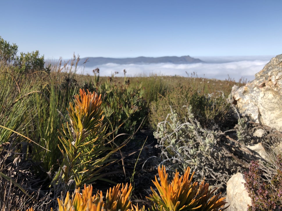
The drizzle was very light and sporadic, but due to the vegetation growing into the path, it wasn’t long before we had drenched lower bodies. It was beautiful though, as the vegetation transitioned between short grass, shrubs, and towering fynbos, waves of cloud rolling by, often reducing the visibility to about 50m.


We had the option of taking a high road or low road, and the trail markers and my maps weren’t very helpful. Notice the trend? Based on the little info I have now, and looking back at our GPS track, I think we took the lower path.
And climbed steadily, the sky getting lighter as we made our way through the layer of cloud. We passed the Three Sisters Peak, which looked quite foreboding. About 3.5hrs into our hike, quite a tough climb took us to the perfect lunch spot: at the top of a valley, overlooking Kleinmond. Or at least, the cloud layer covering Kleinmond, Victoria Peak rising out of the cloud spectacularly!


“So guys,” I addressed the group around mouthfuls of apple, “We can either go up there,” I pointed to the Perdeberg Peak, “or make our way back to the start of the trail that way,” I pointed to the left of where we sat, at a path along the mountainside.
Three tired faces looked back at me. Their expressions said it all. I was relieved, but I didn’t show it. My body was still sore from yesterday’s hike, and as great as it would have been to summit the Pederberg Peak, it would have required a big physical and mental push. We all decided we had done a lot, and that with the cloud below, the view wouldn’t be that spectacular. And we were tired. And it turned out to be quite a warm day, and we had gone through a lot of water.
“Shortcut” or not, the views were dramatic, and soon we were back on the jeep tracks, and steadily going downhill. Which sounds awesome, but our quads were starting to object. We came across a grandfather and his grandson, and their dogs. But apart from them, we didn’t see any other people on the trails for our 2-day hike.


There was little to no shade from the time we left the split to the Perdeberg Peak, and we spent 2.5-3 hours walking in the sun. A bit of cloud drifted up the mountain and offered a brief respite from the sun, but also had us pulling on a layer as the temperature plummeted.

Are we there yet? We could see where we had parked the car, and it gave us a little boost. But it didn’t last that long. We were all deep in our own little worlds. We neared yesterday’s first water obstacle, and found some trail markers. Oops. And try as I might now, I can’t remember the exact details of the route and makers for the first section, so I can’t pass them on to you, my fellow hikers.

We got back to the car, slid off our packs, and all promptly lay down on the grass. After a very short power nap, we packed everything into the car and piled in. Tired, sore, a little smelly, but stoked to have spent two days out in the mountains.

It is a great hike and while quite long, isn’t very strenuous. You could shorten it and cut out the lagoon, but that would require a bit of a slog along the tarred R44. The major plus about this route is that you don’t need to carry tents and sleeping bags and all the kit required to camp. So it is a good choice for people new to hiking, or worried about their fitness (or seasoned hikers who want a chilled hike).
I’d like to do it again, maybe even run day 1, and hike day 2. When I do go again, I will be sure to document the route better!
Information on the hike: http://www.capenature.co.za/wp...
What I learnt:
Take two pairs of shoes – leave one pair at the accommodation.
Hiking boots aren’t necessary – trail runners / any shoes that are sturdy should suffice.
Take a pair of flip-flops and a hand/travel towel with for the water crossings.
There is very little shade, take a hat, sunscreen, and plenty of water.
We want to acknowledge and thank the past, present, and future generations of all Native Nations and Indigenous Peoples whose ancestral lands we travel, explore, and play on. Always practice Leave No Trace ethics on your adventures and follow local regulations. Please explore responsibly!
Do you love the outdoors?
Yep, us too. That's why we send you the best local adventures, stories, and expert advice, right to your inbox.


