
Mike Gromer
As others have said, it's really hard to articulate how mind blowing this place is. The hike in and out may be long, but it wasn't too bad. In the summer months, leave super early to avoid the head (think 3AM or so). Also, remember some cash, the tacos on town hit the spot when you get there after the hike in!
5.0
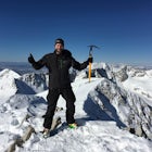
I just did this yesterday on a perfect blue sky day! We had some of the best views I've seen in the Wasatch from the summit. I would add that crampons were really nice for the ridge going up to the S/SE face, as well as on said face. The snow was like concrete, so we elected to not ski that face down due to the exposure below. One more thing I would mention is do not forget sun screen and sun glasses. I did, as we started out at 4AM, and I tend to forget these items when it's dark out. Oops!
5.0
I just did this hike last weekend with two friends. It was a LOT of fun, and tough. We hiked in Saturday to our site, which was about 10 miles in from the trailhead, near a waterfall. Hung out around the site for a bit, explored a bit, then finally had dinner and went to bed by 8PM. Got up at 2AM, were hiking by 3AM, were on the summit at 7:17AM, and back to camp by 10AM. We hung out a bit there, ate lunch, and then left, and were back to the trailhead by 5PM. To add more detail to the route description, everything is easy to find and well marked up to the top of Gunsight Pass. We took the short way towards Dollar Lake when we got to the Elkhorn Crossing intersection. Next time I will set aside more time for the hike and take the long way at Elkhorn. After Gunsight Pass, it gets far less tracked out. The trail isn't as obvious, which is a lot tougher at 4AM with no light. Luckily, we did have a full moon (night before the super blood moon we just had), which gave us far more light than we would have with a new moon. Carins are spaced out and pretty large for a while, but we ended up getting off trail when we had started working our way up to Anderson Pass. This left us scrambling over the rocks at the base, instead of being on the smoother trail up to Anderson. If it's dark, go slowly and scan everything for the carins. On the way down from the peak, we hugged the ridgeline pass Anderson, and dropped back into the area we were camping via the wide, steep chute about 1/4 - 1/2 mile from where the Anderson Pass trail crests the pass. This route cuts ~4 miles off your trip, but it's *really* steep, and very loose. Space out if you do this route with multiple rocks, because as you walk, you're knocking rocks down the slope, and they sometimes roll far and bounce high. Next time I do King's Peak from this trailhead, I am not sure I'd do this route down again. For campsites in the area, be aware that there are a lot of swampy areas. They're generally pretty easy to spot, as they are covered in short brush. Navigating around and through them can be an adventure, and it was nice having the legs zipped on for it. There are LOTS of places to camp, and we had water sources. We were near a waterfall at just under 11,000' elevation. Lakes all over, and streams were pretty easy to find. If you have ankle issues, or have had ankle injuries in the past, boots may be nicer than hiking shoes. I fractured my ankle just over a year prior to doing this hike, and my boots helped me reduce motion when I rolled it a couple times on this hike.
5.0
If you mountain bike, this is an absolute must ride trail. Ideally, you'll shuttle up into the La Sal mountains as high as the weather allows, hopefully being able to do The Whole Enchilada. Regardless, Porcupine Rim is one of the best trails on the planet.
5.0
I've done this once, and it was amazing. Lucky for me, we went into Coyote Gulch just after the 4th of July in 2011. For those of you who don't remember, that was the summer after the very long 2010/2011 winter. Temperatures were very mild, maybe making it into the 80s. The creek was also flowing the entire time. On day 1 and day 3 of the trip, we didn't see anyone on the trails at all. On the middle day, we saw ~10 total people, and that's because we went on a dayhike from our site. We did need the rope we brought with to lower and raise our packs over the cliff face when first going into the gulch and leaving it. I'm not talking about climbing rope, but nylon rope you'd use to hang clothes on, or secure things in a trailer. I really can't wait to get down there again!
5.0
I finally went out to Diamond Fork in February this year for the first time, and had a ton of fun! There was some snow coverage on the trail, but not much. Where there was snow, it was more like ice, so on any incline/decline, we had to be very careful. Two things I would add to the pack list are water shoes, like Keens or Chacos (sometimes you step on a sharp rock, or worst, a hot water seep, where you can get burned), and a head lamp (obviously depends on when you plan on being out there).
5.0
This is my favorite trail in the Salt Lake area, and I ride it many times a season, as I can go Guardsman to the Park & Ride at the base of Millcreek Canyon in under 90 minutes. Beautiful views of Big Cottonwood Canyon, Millcreek Canyon, and all the fun stuff over on the Park City side of the ridge. I would like to add that there are a couple junctions that you'll want to pay attention to. One is once you've cleared The Spine (very obvious rock section overlooking Desolation Lake). The trail will fork (there's a little wooden sign at the fork, not sure what it says), and you want to stay right, to get up into Millcreek Canyon. If you head left here, you'll end up at the Mill D trailhead in Big Cottonwood Canyon, and not back into Millcreek. Later on in the ride, after this fork, you'll hit a T intersection. Go left. You'll see a sign about bikes not being allowed in Millcreek Canyon on odd days, so you'll know you're going the correct way. If you go right here, you'll end up in The Canyons Resort.
5.0
The Phil's trail system is do much fun! It's really easy to ride much further than you think here, as it's so flowy. I found myself pedaling for hours without realizing it.
Community
Mobile Apps

© 2024 The Outbound Collective - Terms of Use - Privacy Policy