
Hike the Ceran St. Vrain Trail
Ward, Colorado
Details
Distance
4 miles
Elevation Gain
1207 ft
Route Type
Out-and-Back
Description
Added by Johnathan .
An easy trail through the forest and along a river bank with ample supply of shade for hot summer days.
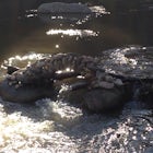
The Ceran St. Vrain trail north of Jamestown offers the hiker a nice respite from the summer sun as this path runs through dense pine forests. The trail follows the South St. Vrain Creek for most of the way and follows moderate grades throughout. There is no official end to the trail, only that it joins with the 801-252 Jeep road. This is it's unofficial terminus, although some maps will show connecting spurs or trails from here if you wish to continue your journey.
Roundtrip, the trail is just shy of 4 miles and is perfect for a quick one night backpacking expedition or a half day hike. After parking at the trailhead and crossing the sturdy footbridge over the South St. Vrain Creek, there are multiple unofficial backcountry campsites.
The area is also good for seeking out wildflowers, which thrive along the creek. Keep your eyes peeled for columbines and Fairy Slipper Orchids.
Download the Outbound mobile app
Find adventures and camping on the go, share photos, use GPX tracks, and download maps for offline use.
Get the appFeatures
Hike the Ceran St. Vrain Trail Reviews
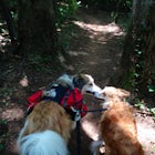
ATTENTION: Edit - As of May 11, 2021 dispersed camping is now illegal on this trail. The ordinance is good for a year, so here's hoping we'll be able to use the trail next year for camping. Punishable by $5,000 fine or 6 months in jail, or both. This is a nice beginner trail, very low exertion with slight elevation changes as you follow the river. The river is almost always in sight, gorgeous hiking. Very dog friendly hike, the trails are mostly packed dirt, so paw pads should stay untorn. The is a dispersed camping trail as well, lots of great spots by the river, the best spots are a little further in. No car camping is allowed here. There are no facilities (trash, water, toilets) so plan to hike in and out with everything. There are currently fire bans, so also pack for stove cooking and warmth. It does get chilly at night with the river so close. Great stargazing though, far enough from Boulder for the stars to really light up. Don't follow Google Maps! You will get lost! Take 36 through Boulder about 5 miles north of Boulder, take a left on Lefthand Canyon road. You will pass through Jamestown, and the road name will change to Overhead Rd (or something like that). Just stay straight on Lefthand Canyon about 15 miles and the trailhead is on the right.
5.0
Leave No Trace
Always practice Leave No Trace ethics on your adventures and follow local regulations. Please explore responsibly!
Nearby

Snowshoe Long Lake

Snowshoe Mount Audubon

Winter Camp at Lefthand Reservoir

Explore Red Rock Lake, CO

Hike Meadow Mountain

Catch the Sunrise on Sugarloaf
Community
Mobile Apps

© 2024 The Outbound Collective - Terms of Use - Privacy Policy