
Hiking to Karst Spring in Kananaskis Country
Kananaskis, Alberta
Description
Added by Chase Dekker
Distance: 6 miles roundtrip. Elevation gain: 650 ft. Spectacular scenery of the Canadian Rockies. Quiet hike with very few people. Fantastic wildlife-viewing opportunities. Well maintained and clearly marked trail.
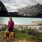
Every year, over 5 million visitors make their way through Banff National Park to soak in the surrounding peaks, bountiful wildlife, and turquoise-colored lakes. With this many visitors, it's hard to find yourself alone, especially during the peak seasons of summer and fall. Right next door to Banff National Park, however, is a beautiful little secret: Kananaskis Country.
Kananaskis Country lies just south of the town of Canmore, and just 5 miles away from the town of Banff and the National Park, itself. Kananaskis Country is known for it's untouched valleys that are home to wolves, grizzly bears, and a moose population larger than that of Banff National Park. Find yourself in complete solitude and get acquainted with the area along the Karst Spring Trail.
The first 1.5 miles of this hike travels through an open meadow with views of the surrounding peaks. When you arrive at the T-intersection, turn left to head downhill to Watridge Lake, a good location for trout fishing. From the lake, follow the trail towards Karst Spring, about 0.6 mile from the away, following the sound of the water's roar.
As you continue towards the spring, you will pass a beautiful creek that is generally high-volume due to snow-melt. The spring will be just ahead, with a well-maintained viewing platform and an information sign.
Karst Spring bursts out of a rock face, draining from passageways between limestone layers of Shark Ridge and creating a karst formation. Snow and rainwater seep into cracks and dissolve the rock, creating tunnels from which streams begin.
Getting there: Drive 24 miles south of Canmore on Highway 742 (Smith-Dorrien/Spray Trail) and turn right at Mt. Engadine Lodge Rd. Drive slowly, here, as the meadows have many mineral mud pots that often host moose and grizzly bears. Continue for about 3 miles, keeping right at every intersection, until you reach the Mt. Shark parking lot. The trailhead is just behind the information sign beside the lot.
Download the Outbound mobile app
Find adventures and camping on the go, share photos, use GPX tracks, and download maps for offline use.
Get the appFeatures
Hiking to Karst Spring in Kananaskis Country Reviews

This place is next on my list it looks amazing!
5.0
Great scenery throughout! The spring is pretty cool especially when it's really pumping the volume during spring melt!
4.0
Leave No Trace
Always practice Leave No Trace ethics on your adventures and follow local regulations. Please explore responsibly!
Nearby

Bryant Creek Lodge via Watridge Lake Trail

Hike Along Tent Ridge

Running on the Tent Ridge

Scramble Smutwood Peak

Snowshoe to Rummel Lake and Pass

Exploring Burstall Pass
Community
Mobile Apps

© 2024 The Outbound Collective - Terms of Use - Privacy Policy