
Century Sam Lake
Comox-Strathcona C, British Columbia
Details
Distance
3.62 miles
Elevation Gain
1342 ft
Route Type
Out-and-Back
Description
Added by Sarah Seads
Some of the many highlights of this hike are the stunning emerald lake and snow caves. It's a short dayhike perfect for a quick weekend escape.
The next time you have the opportunity, I recommend you pay Century Sam Lake a visit. This short day hike complete with a spectacular emerald green lake, towering rock cliffs and summer snow caves make this a 'must do' for mid Island adventurers.
This day hike is a well kept secret – and often well kept behind a locked gate. Access to Century Sam is at the end of a private road owned and secured by Timberwest Forest Co. Access to the road is limited to a few weekends during hunting season (October) and Comox District Mountaineering Club trips who have permissions to access the road on set dates throughout the year. If you are lucky enough to time it right, you can gain access to three trails at the end of the Comox Logging Road: Alone Mountain Trail, Century Sam and the Comox Glacier route itself.
To access the trail head of both Century Sam and the Comox Glacier route, follow the Comox lake Main, then Cruickshank Main, about 17.5km to the junction with South Main. Head left on South Main for approximately 7kms, then keep right for approximately 2kms until you reach Datsio Creek. Park here unless you are driving a 4 by 4 vehicle with high clearance as there are cross ditches beyond this point and very few places to turn around (if any). From here, take the right fork for approximately 2kms to reach the trail head on your left.
A few metres into the hike, there is a fun log crossing and then the trail splits shortly after. Take the right fork to Century Sam (or left if you were heading up to the Glacier). The trail is beautiful in it's own right, taking hikers on a tour through massive moss covered boulder fields, big timber and multiple rock slides. The trail works it's way steadily upwards covering 400m of elevation over approximately 5kms and follows Comox Creek to the outflow of Century Sam Lake. Most hikers can expect the trip up to the lake to take between 1.5 and 2.5 hours.
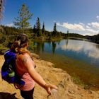
The lake is a mind blowing emerald green. Fed by snow melt, the temperature is chilly, but refreshing on a hot summer day. There is a nice rocky outcropping above the lake, that makes an inviting spot to sit in the sunshine and enjoy lunch. A cairn sits on the edge of the lake in memory of Sid Williams, a local adventurer who was also an actor and lived in the Comox Valley:
“Honouring Sid Williams of Courtenay, who played the role of ‘Century Sam’, the old prospector, during our 1958 British Columbia Centennial celebrations. Sid was an actor and comedian, a tireless volunteer who enriched the community. In 1984, he was awarded the Order of Canada for his lifetime of irrepressible humour and his service to others. Sid was also a keen hiker and skier who loved these mountains. Remembered by family and friends. 1992.”
But don't stop at the lake.
Carry onward on the path, over the rocks and to the back of the lake where you will enter a magical amphitheater. Complete with rock walls, cascading waterfalls and a massive snow cave, this magical spot is loaded with natural energy. Directly above, atop the rock walls, sits the Comox Glacier's south summit. The snow cave appears in summer, after the collection of winter snow has melted enough to create the huge arch. Depending on the season, the snow may cover the lake right until the end of summer. This year, after a poor snow pack and hot summer, it had retreated nearly all the way to the towering rock behind. The cave boasts a 30-40 foot ceiling and spectacular shimmering ice blue walls. Use caution if you choose to approach the ice cave as there is no telling when it may crumble and large chunks of ice are seen collapsed on the ground of the tunnel. Enter at your own risk.
I have lived on Vancouver Island my entire life and only just now discovered this magical place. These magical places fill me with a sense of wonder as to what else is out there. And remind me to keep exploring, right in my back yard.
Happy Trails!
More Information:Beyond Nootka – A Historical Perspective of Vancouver Island Mountains, Lindsay Elms, Misthorn Press, 1996, ISBN 0-919537-29-4For route information further into the backcountry, refer to Island Alpine – A Guide to The Mountains of Strathcona Park and Vancouver Island, Philip Stone, Wild Isle Publications, 2003, ISBN 0-9680766-5-3Backroad Mapbook. Volume III: Vancouver IslandTimberwest Forest Co. Recreational Access InformationComox District Mountaineering Club
Download the Outbound mobile app
Find adventures and camping on the go, share photos, use GPX tracks, and download maps for offline use.
Get the appFeatures
Century Sam Lake Reviews

Thank you Sarah Seads for your description of the hike and directions with how to get there. I wrote down everything you said on a piece of paper and brought it with me as there is no service on the hike to Century Sam Lake. Tanja's suggestion for you to change the elevation is incorrect, you are correct Sarah. From the trailhead to the lake, the elevation is about 368m. This is what the map said at the trailhead and what my Apple Watch told me, so 900+ m is incorrect :) The hike was difficult but so worth it!! Thanks again for your directions Sarah as your guidance made the trip a lot more efficient. We started the hike at 2pm and got back to the car at 6pm which meant we had just enough time to drive back out of the gates before 7pm when they lock. So, don't start the hike past 1 or 2 pm!! You're cutting it close if you wait too long.
5.0
This is not a hike for beginners. It is up hill all the way to the lake. Some very technical spots, even when decending. Your blog in the paragraph that states it's a steady 400m elevation gain is incorrect. It's more than double that - 930 m. Please change so that others dont think its so easy...its not. The payoff of the gorgeous lake is stunning though. Be sure you have lots of water, filtering device, and ready for the challenging hike. Full disclaimer- we had heavy packs and overnighted. Climb is nuts with a pack.
3.0
The hike to the lake sucks. No doubt about it. All of it up a mountain and most of the elevation gain is in the last 2.5 km or so. Being tons of water or a filtering device. The trail is really well maintained but some parts of it are muddy and slippery. I highly recommend really good hiking boots and trekking poles if you have them. Once up at the lake you see how colourful it actually is. Like aquamarine kool aid. The gate to access the forest road to get to the trail head is only open on weekends during the summer fork. Friday at 6pm to Sunday at 8pm. If you expect to be the only ones out there you won't be. It's surprisingly very popular.
4.0
Leave No Trace
Always practice Leave No Trace ethics on your adventures and follow local regulations. Please explore responsibly!
Nearby

Hike Mount Becher

Hike to Flower Ridge

Exploring Myra Falls

Climb Mt. Septimus via the X-Gully

Backpack to Circlet Lake Campground

Lake Helen Mackenzie Loop
Community
Mobile Apps

© 2024 The Outbound Collective - Terms of Use - Privacy Policy