
Humphreys Peak Summit
Flagstaff, Arizona
Details
Distance
9.57 miles
Elevation Gain
2759 ft
Route Type
Out-and-Back
Description
Added by Sri Gangam
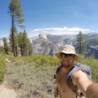
Enjoy spectacular view of east and west side of Humphrey's Peak, the highest point in Arizona at 12,637 feet.
If you think you might only get one chance to hike Humphreys Peak in your life, I recommend this hike so that you can have a unique view experience of the east and west sides of the Peaks. This is a shuttle hike of Humphreys Peak which combines the Humphreys Peak Trail and the Humphreys via Inner Basin hike.
Start at Lockett Meadow, which is 7.1 miles to the peak, but has more gradual elevation gain. The trail leading into the heart of the ancient volcano begins in beautiful Lockett Meadow. The extensive stands of aspens cover the steep slopes of the old caldera and this is a great place to see fall colors. The Inner Basin Trail will eventually intersect with the Weatherford Trail after 3.7 miles hike from the trailhead. After hiking 2.5 miles on Weatherford Trail you will reach Humphreys Saddle, where the Weatherford Trail ends at the Humphreys Summit Trail. Then, follow the Humphreys Summit Trail for 1.0 miles to Humphreys Peak, which is the tallest point in Arizona at 12,637 feet.
After soaking in the views from the highest point in Arizona, turn around and hike 1.0 mile back to Humphreys Saddle. Finally, continue down the Humphreys Summit Trail toward Snowbowl for the final 4.1 miles. After finishing the hike you can camp at Freidlein Prairie Dispersed Camping (FR 522). The scenery of this campground is peaceful and It sits in a grove of pines.
Note: it's going to take a while to drop off and pick up your shuttle vehicles, so be sure to think about precisely when and how you're going to accomplish this. It's important to keep the weather forecast in mind. Desert storms can shift and appear out of nowhere.
Directions to Inner Basin Trail:Drive northeast of Flagstaff on US Highway 89 for 12.5 miles. Turn left on Forest Road 552, directly across from the Sunset Crater National Monument turnoff. Follow FR 552 for approximately one mile.GPS: 35°21'23.2"N 111°37'22.6"W
Directions to Huphreys Peak Trail:Location: 14.5 miles northwest of Flagstaff on paved roads.GPS: 35°19'52.4"N 111°42'42.2"W
Download the Outbound mobile app
Find adventures and camping on the go, share photos, use GPX tracks, and download maps for offline use.
Get the appFeatures
Humphreys Peak Summit Reviews

This was the first hike to a summit for me and it was great! It was without a doubt the hardest thing I've ever done. I live in the mid-west where there is no elevation, so I wasn't prepared for the toll the elevation would take on me, but with some slow steady steps, I was able to summit with my wife in 7 hours.
5.0

A fun hike with gorgeous wild flowers in the Spring. The top has a bad rap for lightning strikes so getting to the peak and leaving before 1PM is ideal.
5.0

Did this hike last year and probably shouldn't have submitted. It started hailing just as we passed the saddle but we pushed on anyway. Definitely wasn't a smart decision, so make sure when you do this hike you get to the summit before the afternoon storms hit.
5.0

We started off in Lockett Meadow and carried all of our gear up to the tree line where we set up camp. It was definitely challenging, but worth it! Below the tree line it's beautiful! It's nice and forest-y. You almost forget you're in Arizona. Past the tree line and until you reach the summit, it's a little barren but the view is wonderful.
5.0

Great hike with a great view at the top. Definitely an advanced hike, but very rewarding.
5.0
The hike to the top of Humphrey's Peak is refreshing. The ascent took me about 2.5 hours and was well worth the effort. It was hard to believe that I was in Arizona, because everything was so green and alive!
5.0
Leave No Trace
Always practice Leave No Trace ethics on your adventures and follow local regulations. Please explore responsibly!
Nearby

Hike the Aspen Nature Loop at Humphrey's Peak

Winter Summit Humphreys Peak, Arizona

Trail Run in Lockett Meadow

Hike Inner Basin Trail #29

Hike Aspen Corner to Bismark Lake on the Arizona Trail

Abineau-Bear Jaw Loop
Community
Mobile Apps

© 2024 The Outbound Collective - Terms of Use - Privacy Policy